George W. Liles Pkwy Small Area Plan Draft
George W. Liles Pkwy Small Area Plan Draft
THE PUBLIC COMMENT PERIOD IS NOW CLOSED.
THANK YOU FOR YOUR PARTICIPATION!
NEXT STEPS
Planning & Zoning Commission Meeting on July 19, 2022 @ 6 PM
City Council Work Session on August 9, 2022 @ 4 PM
City Council Regular Session on August 11, 2022 @ 6 PM
INTRODUCTION
The purpose of this Small Area Plan for the George W. Liles Pkwy Corridor is to clearly articulate a vision and define goals for future development and public investment in the study area. This plan will serve as a guiding document to reference for the next 15 to 20 years.
Based on public engagement, market analysis, and substantial input from stakeholders, the following vision was developed for the Study Area:
Future development of the George Liles corridor should include vibrant live-work-play communities with a focus on healthy active living, and connected & accessible places, ultimately enhancing the quality of life of residents and the community.
In support of the Vision, the plan outlines implementation steps from an infrastructure, policy, and regulatory perspective. Specifically, the plan recommends a vision for the following:
Live-Work-Play Community
Live-work play communities are rooted in the idea that people are happier living in neighborhoods that provide for most of their needs. A live-work-play community has a variety of housing, is close to local workplace options where residents of the community work, and provides places for recreation, shopping, eating, and entertainment. Live-Work-Play communities provide benefits such as convenience for low-stress living, more walking, a healthier lifestyle, and greater connection with neighbors.
Healthy & Active Living
Healthy and active living choices, beyond their natural habits, involve the provision of infrastructure and amenities that encourage healthy activity and access to healthy food. In a general study of active living infrastructure, indicators may include miles of bike lanes, sidewalks, greenways, and amount of active open space, while access to healthy food may be measured by the proximity of a population to grocery stores. These amenities are among the top desired to drive demand for both housing and workspace development and will continue to be important in the post COVID-19 recovery. The George W. Liles Pkwy could be uniquely positioned as a place that is driven by healthy choices in exercise, food, environment, and sustainability. Community gardens, farm-to-table restaurants, and urban mini-farms could anchor key catalyst lifestyle master-planned developments and tie into the history of the area.
Connected & Accessible Places
A key feature of connected and accessible places is a multi-modal transportation network that links the land uses along the corridor and accounts for all users in a way that minimizes conflict. For this small area plan, the ideal transportation network will provide access from the neighborhood to employment and lifestyle centers and from employment and industrial centers to major transportation routes. Connected and accessible places create an intuitive, safe network that is attractive to users of all ages and abilities. This infrastructure attracts businesses and employers because of the high quality of life and sense of place that ample connectivity can provide.
Enhanced Quality of Life
Local community culture and quality of life are both drivers for workforce development and include things like housing choices, transportation options, proximity to parks/greenways, and places for dining, shopping, and entertainment based on connectivity and experience. This Small Area Plan aims to layout growth and future development along the George W. Liles Parkway in such a manner as to enhance the community’s quality of life and position the George W. Liles Pkwy Corridor as a place people want to live, work and visit.
PLAN BOUNDARY
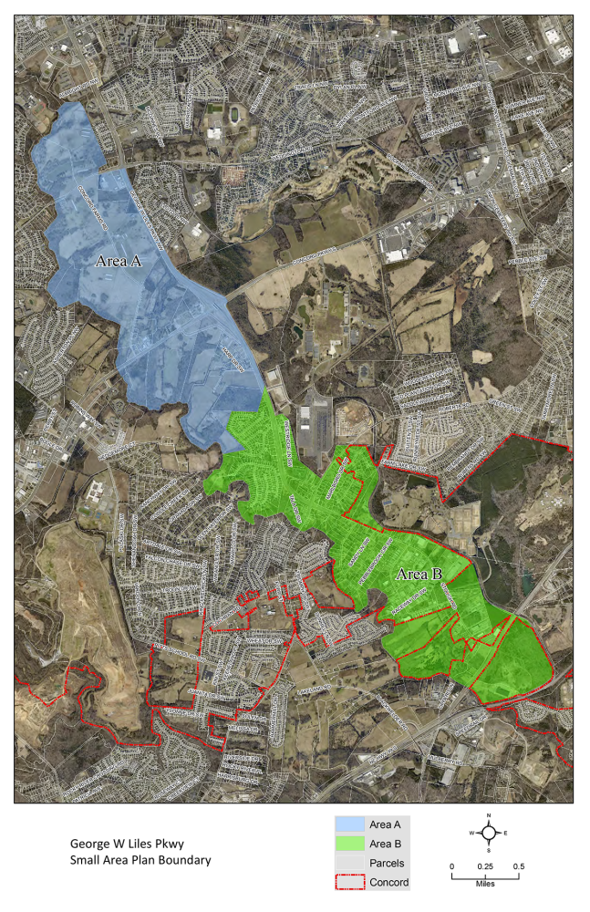
The boundary for the George W. Liles Pkwy Small Area Plan encompasses the George W. Liles Pkwy Corridor from Weddington Road to US Hwy 49. Covering 2,418 acres, this plan has been divided into two distinct study areas.
Area A: Largely comprised of undeveloped land located in the Central Concord District per the 2030 Land Use Plan. Closely matches the 2005 Concord Parkway/Roberta Church Road Small Area Plan boundaries.
Area B: Mostly residential with some small-scale industrial and undeveloped land near Hwy 49.
For questions please contact Design Manager, Kaylee Caton at 704.920.5151 or catonk@concordnc.gov
This is hidden text that lets us know when google translate runs.

