|
|
|
|
|
|
|
|
|
|
|
|
|
|
|
|
|
|
|
|
Sharp Street Bikeway Community Engagement 
The Baltimore City Department of Transportation’s (BCDOT) Sharp Street Bikeway project seeks to make a multimodal connection on Sharp Street between Pratt Street and West Henrietta Street that will improve safety for people biking, scootering, and rolling (e.g. using a wheelchair) by creating an all ages and abilities facility. This connection will also fill a gap in the City’s multimodal network by connecting the Maryland Avenue cycletrack, and larger protected bike network, to the Greenway Trails Network.
As of August 2026, BCDOT is resuming work on the Sharp Street Bikeway project and building off the engagement and design work completed in 2023.
BCDOT is looking forward to reconnecting and engaging with community members to solicit their input on how they'd like to see Sharp Street improved. Feedback gathered during engagement will inform the project design. Here's how you can get involved and share your thoughts:
- Leave a comment or question using the comment box at the bottom of the project page.
- Connect via your neighborhood association. As additional meetings are confirmed, BCDOT will share all event or meeting details on the project page. Stay tuned!
- Thursday, September 24, 7 p.m. at the Otterbein Community Association Meeting. Location TBD.
- Meet BCDOT on Sharp Street. Staff will be out there and looking to connect with people who walk, bike, roll, drive, or take transit along the corridor. Here is when you can expect to see DOT staff out there in September:
- Tuesday, September 15 from 7:30 to 8:30 a.m. at Pratt Street and Sharp Street intersection
- Wednesday, September 16 from 4:30 to 5:30 p.m. at Pratt Street and Sharp Street intersection
To learn more and comment, visit the Streets of Baltimore project page.
|
|
|
|
|
|
|
Kindler Road Pedestrian and Bicycle Bridge Feasibility Study Public Meeting September 15
The Howard County Office of Transportation is conducting a study to evaluate the feasibility of constructing a pedestrian and bicycle bridge over the Middle Patuxent River, creating a multimodal transportation connection between Kindler Road and Eden Brook Drive.
Photo: Kindler Road Bridge Feasibility Study Map
The purpose of this phase of the study is to identify a preferred crossing location and bridge concepts that will lay the foundation for future phases as the project moves into design alternatives.
This study was funded by the Baltimore Regional Transportation Board’s (BRTB) Transportation and Land Use Connections (TLC) grant program in Fiscal Year 2025.
A public meeting will be held on Tuesday, September 15, from 5 p.m. to 7 p.m. to discuss the concepts created for the feasibility study. The meeting will be held at Amherst House, 7251 Eden Brook Drive, Columbia, MD 21046. A feedback survey will be linked on the project page after the public meeting, and will remain open until Friday, October 2.
Questions on the study can be directed to transportation@howardcountymd.gov.
View the project page to learn more.
|
|
|
|
|
|
|
Maryland Department of Transportation Celebrates Two Years of Complete Streets
The Maryland Department of Transportation (MDOT) is celebrating the two-year anniversary of its Complete Streets Policy, a department-wide commitment to building safer, more accessible and equitable transportation networks for everyone, including people walking, biking, rolling, riding transit and driving.
Adopted in June 2024, the policy established a framework that requires transportation projects on MDOT’s right of way to be planned, designed and implemented with all users in mind. It reflects Maryland’s commitment to safety, public health, economic vitality, environmental stewardship and equitable access.
Efforts from the Complete Streets Policy helped reduce fatal crashes by 18% statewide in 2025 compared to 2024. The largest gains were seen among people who walk, bike and roll.
Major MDOT achievements during the first two years of the Complete Streets Policy include:
- Upgraded more than 1,300 crosswalks, reconstructed 11.26 miles of sidewalks and built 13.34 miles of new sidewalks to enhance the safety for all users, including pedestrians and bicyclists;
- 23 projects in various corridors were identified for safety improvements as part of the Pedestrian Safety Action Plan (PSAP). Projects are in various planning, design and implementation stages, with construction completion expected this fall on the first PSAP project on MD 650 (New Hampshire Avenue) in Montgomery and Prince George’s counties;
- 10 Quick-build safety projects across the state, designed for short-term, easily implementable projects to pilot innovative improvements and address existing vulnerable road user safety needs;
- A record $500+ million investment in active transportation projects programmed into the Department’s six-year capital budget; and
- A new Maryland Transportation Trails Strategic Plan, updated in 2025 for the first time in 16 years.
Complete Streets is part of the MDOT Serious About Safety initiative, a department-wide commitment to advance improvements that drive safety goals and save lives.
To receive monthly email newsletters about active transportation and complete streets updates, subscribe to MDOT in Motion.
Read the full press release here.
|
|
|
|
|
|
|
Anne Arundel County’s Land Preservation, Parks & Recreation Plan Public Meetings

Help shape the future of Anne Arundel County’s Recreation and Parks through the 2027 Land Preservation, Parks & Recreation Plan (LPPRP).
Join an upcoming 2027 LPPRP Public Meeting to hear public feedback gathered so far, share your input, and learn about next steps. All meetings run from 5:30 p.m. to 8 p.m.
- Tuesday, September 1 at the Deale Library (5940 Deale Churchton Road, Deale, MD 20751)
- Thursday, September 10 at the Brooklyn Park Library (1 E 11th Avenue, Brooklyn Park, MD 21225)
- Tuesday, September 15 at the Pip Moyer Recreation Center (273 Hilltop Lane, Annapolis, MD 21403)
For questions or comments, email lpprp-2027@aacounty.org.
|
|
|
|
|
|
|
Orleans Street Rehabilitation Survey

The Baltimore City Department of Transportation (BCDOT) has begun the process of reimagining Orleans Street from Washington Street to N. Ellwood Avenue. This portion of Orleans Street features in the Tier 1 segments of the City's High Injury Network.
Orleans Street (US Route 40) is a vital Baltimore corridor, but it is also a roadway where residents and corridor users have consistently identified concerns related to speeding, crashes, and pedestrian safety. Public safety data and transportation studies support these concerns and highlight the need for improvements.
BCDOT wants to work with the community to develop solutions that address these issues. Your feedback will help guide decisions that improve safety, accessibility, comfort, and connectivity for everyone who uses the corridor.
BCDOT hosted a public meeting for this project on Monday, August 24 at the Patterson Park Enoch Pratt Library branch.
The DOT project team has come up with several design alternatives that meet Complete Streets requirements and safety needs. The community can review these designs, provide feedback, and vote on their preferred alternative starting at the August 24 public meeting and continuing throughout September. A design decision will be made in October based on community feedback, preference, and engineering judgment.
To learn more and comment, visit the Streets of Baltimore project page and StoryMap.
|
|
|
|
|
|
|
Clarksville Transportation Projects Community Outreach Meeting
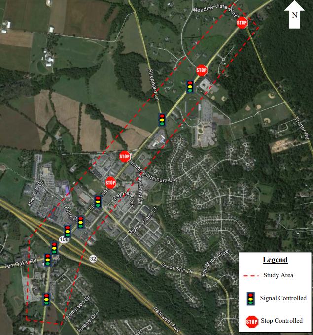
Howard County's Department of Public Works’ (DPW) and the Office of Transportation (OoT) are currently in the process of advancing the County’s “Clarksville Pike Streetscape Plan and Design Guidelines” to develop plans for a system of shared-use pathways, sidewalks, crosswalks, and bike lanes along this stretch of roadway in Clarksville.
Photo: Clarksville Pike Study Area
The MD 32 Alternate Bike Route Pinch Point 6 project will provide a viable and safe bicycle route and associated infrastructure improvements along Ten Oaks Road, which was identified as a replacement bicycle route for the MD 32 corridor.
DPW and OoT held a community outreach meeting Wednesday, August 26, in River Hill Village Center’s Claret Hall at 6020 Daybreak Circle in Clarksville, to present design updates for the Clarksville Streetscape and MD 32 Alternate Bike Route Pinch Point 6 projects.
To view the plans and/or have questions, should contact Caitlin Kovel with DPW’s Transportation and Special Projects Division at 410-313-6142 or email ckovel@howardcountymd.gov.
The meeting materials are available on OoT’s “Clarksville-River Hill Streetscape Improvements” website. Community members are also able to complete an online survey to share their thoughts and feedback with the County on these two projects.
|
|
|
|
|
|
|
Back to School: How MDOT is Helping Provide Students with Safe Routes to School
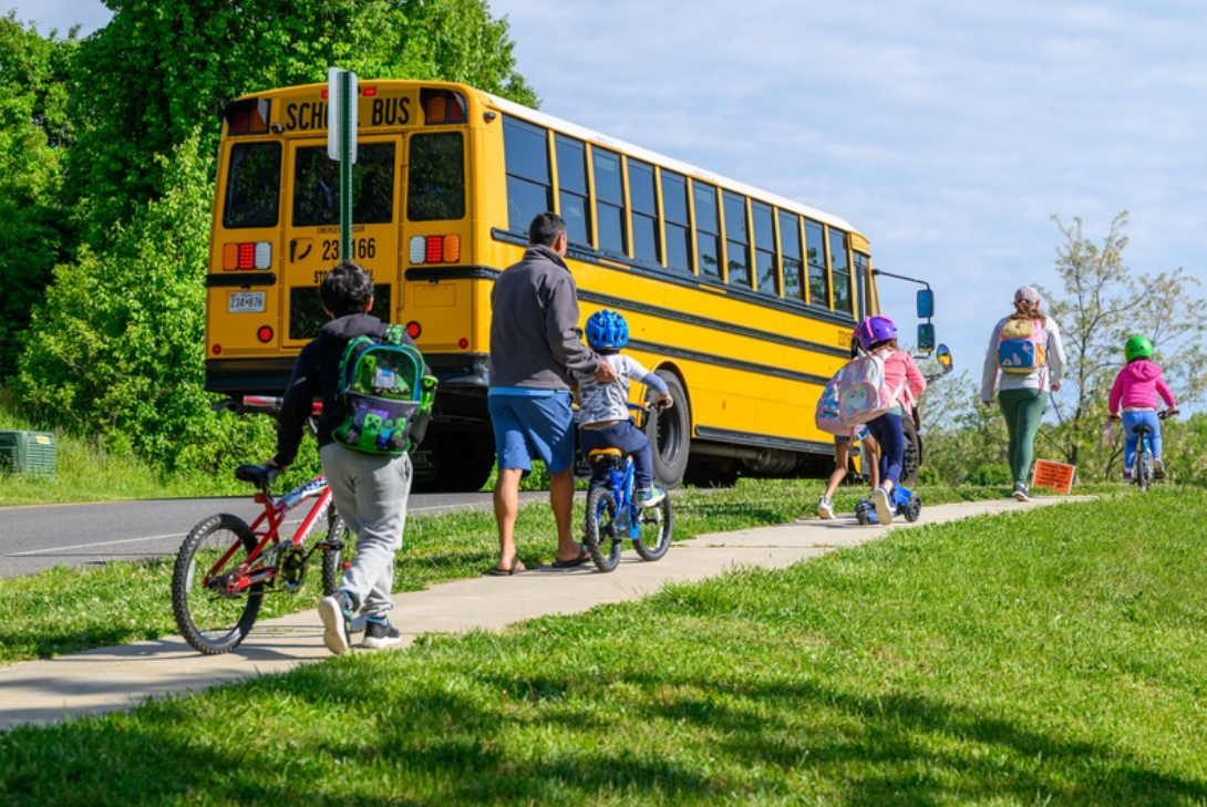
Students walk and bike to school in Ellicott City for national Bike to School Day in May 2026. (MDOT/David Trozzo)
As students and parents get ready to head back to school, the Maryland Department of Transportation (MDOT) has been hard at work trying to make the trip to and from school safer. Through the national Safe Routes to Schools (SRTS) program, MDOT provides communities with the tools needed to make this happen.
In 2024, MDOT launched an initiative to enhance the delivery of SRTS across the state. Through collaboration with the State Highway Administration (SHA), which administers SRTS funding under the Transportation Alternatives Program (TAP), MDOT developed the SRTS Coordinator Pilot Program, a model that has proven successful in other states. Under this program, TAP funds are allocated to local jurisdictions to cover 80% of the salary for an SRTS coordinator.
Baltimore City and Anne Arundel, Howard and Prince George’s counties are the first MDOT jurisdictions who will have Safe Routes to School Coordinators.
The Baltimore Regional Transportation Board (BRTB) recommended TAP funding for the Anne Arundel and Howard County Safe Routes to School Coordinators program starting in FY 2026.
Safe Routes to School Coordinators work closely with local schools. These coordinators will run student safety programs and help choose which safety projects get built first.
The Office of Active Transportation and Micromobility plans to continue gathering the work group once a quarter. The work group provides support to local Safe Routes to School coordinators and their work.
The work group made a Safe Routes to Schools toolkit for local partners. The toolkit is a guide for newly hired Safe Routes to School Coordinators. It is also a resource for anyone looking to start or strengthen Safe Routes to School programs in Maryland.
By working together, Maryland is trying to make every child’s path to school safe, supportive and connected to a brighter future. You can learn more about MDOT’s Safe Routes to School program on the website. For more information about the national Safe Routes Partnership, click here.
|
|
|
|
|
|
|
Howard County’s Preserve+Play Survey

The Department of Recreation and Parks is developing Howard County’s next Land Preservation, Parks and Recreation Plan (LPPRP): a five-year plan to guide management and stewardship of public lands, facilities, programs, and experiences. This plan will be called Preserve+Play.
The plan evaluates baseline information about existing conditions, key issues, and trends to inform goals, strategies, and investment priorities for open space, recreation facilities, resource conservation, and agricultural preservation.
Share how you use Howard County parks, facilities, and programs today and what you'd like to see in the future by taking this short survey. Howard County held three public meetings on Preserve+Play in July.
Want to dig deeper? Learn more about the Preserve+Play plan on this website.
|
|
|
|
|
|
|
Winsor Mill Road Improvements
Baltimore County Department of Public Works (DPW) is planning improvements along Windsor Mill Road. Phase 2 of the Windsor Mill Road project runs from Featherbed Lane to Woodlawn Drive.The project includes roadway widening, sidewalk installation, curb and gutter, storm drains and waterline replacement.
This project will support pedestrian safety and vehicular capacity improvements along Windsor Mill Road by widening the roadway from an existing pavement width of 22 feet to a proposed width of 36 feet (from Featherbed Lane to Woodlawn Drive, approximately 3,400 feet) and by including five-foot sidewalks on both sides of the road. This roadway segment is an essential connection for transit commuters and provides accessibility for adolescents to and from school.
Photo: Project Map. Phase 1 marked in yellow from Woodlawn Drive to Featherbed Lane. Phase 2 marked in red from Featherbed Lane to Lugine Avenue.
A community open house will be held was held on Wednesday, July 15 at the Woodlawn Community Center.
Learn more and view the meeting boards here. Send any comments or questions to WindsorMillProject@baltimorecountymd.gov.
|
|
|
|
|
|
|
Federal Funding for Community-Led projects throughout Maryland.
The fiscal year (FY) 2027 Transportation, Housing and Urban Development, and Related Agencies (THUD) appropriations bill has been enacted into law. This bill secured $69,498,878 in direct federal funding for 46 community-led projects throughout Maryland.
These investments in local projects support community and economic development as well as improvements to public transit and trail networks.
Some highlights for active transportation in the Baltimore region include:
- $2,000,000 for Guilford Road Pedestrian and Bicycle Improvements, Phase 3 (Howard County)
- $3,000,000 for the Baltimore Regional Trail Hub (South Baltimore Gateway Community Impact District Management Authority in Baltimore City)
- $1,416,000 for the Thompson Creek Connector Road & Trail Extension (Queen Anne's County)
- $300,000 for Aberdeen Activity Center Outdoor Recreation Improvements (Harford County)
To learn more, read this press release from the office of Senator Chris Van Hollen.
|
|
|
|
|
|
|
Maryland Highway Safety Office Helmet Distribution
Photo: Event staff helping a child fit a helmet at the Easter Egg Hunt by Parks and People in Baltimore City, April 4, 2026
Baltimore Metropolitan Council (BMC) is in its second year of a Bicycle Safety grant from the Maryland Department of Transportation Motor Vehicle Administration's Highway Safety Office (MHSO). The project aims to provide bicycle helmets to local and regional partners for outreach events, to increase the usage of helmets by riders of all ages. Applicants can request someone to be onsite at their event to help fit helmets and provide safety education.
Any interested partners can contact Cindy Burch (cburch@baltometro.org) or, if outside of the Baltimore region, Cynthia Spriggs at MHSO (cspriggs@mdot.maryland.gov).
|
|
|
|
|
|
|
Howard County’s School Traffic Safety Program
Photo: External school bus camera
As students and staff prepare to return to school on August 24 for the 2026-2027 school year, the Howard County Police Department (HCPD) is working hard to ensure children, parents and teachers all arrive safely. Through its annual back-to-school initiative known as H.A.S.T.E. (Helping Arriving Students Through Enforcement), HCPD officers will focus on enforcing driver and pedestrian safety in school zones.
For the first few weeks of the school year, increased traffic patrols will be in place on roadways surrounding elementary, middle and high schools. Officers will focus on drivers who are speeding, failing to stop for pedestrians or driving distracted in those areas. They will also be checking for seatbelt and child safety seat use to ensure all occupants are properly restrained.
HCPD is also reminding all drivers that buses serving the Howard County Public School System (HCPSS) are outfitted with external cameras. Launched in 2021, HCPD’s External School Bus Camera program aims to ensure student safety by discouraging motorists from passing buses illegally. The state of Maryland’s fine for illegally passing a school bus is $250.
Finally, HCPD’s Speed Camera program is designed to encourage drivers to slow down in school zones and has tiered fines ranging from $40 to $425 based on speed. The cameras are rotated among various school zones in the county, which are posted in advance and updated every week on the department’s “Speed Camera Program” website.
HCPD will continue to conduct traffic safety education and enforcement efforts throughout the school year.
To learn more about traffic safety, visit this webpage.
|
|
|
|
|
|
|
18 New School Zones Across Howard County
Photo: Northfield Elementary School in Ellicott City, one of the locations for a proposed new school zone. Photo credit: Homes.com
The Howard County Department of Public Works (DPW), Bureau of Highways, Traffic Engineering Division, is proposing 18 new designated School Zones to be implemented by signing modifications on County roadways. The project is intended to increase driver awareness and support safer conditions for students walking, bicycling, crossing roadways, using school buses, or being dropped off and picked up near schools.
The purpose of the School Zone Expansion Project is to establish new designated school zones along Howard County roadways where school-related pedestrian, bicycle, and vehicular activities occur or influence roadway operations. The overall goal is to provide a safer and more consistent roadway environment around Howard County schools.
Following completion of the public commenting period, DPW will proceed with installation of the new school zone designation signs. As part of this effort, existing school zone signs that are faded, damaged, or no longer in satisfactory condition are also being replaced.
A virtual public meeting was held on August 12, and comments were accepted through August 24.
To learn more, visit the project page.
|
|
|
|
|
|
|
Metropolitan Washington Council of Governments Dockless Shared Micromobility Workshop

The Metropolitan Washington Council of Governments (MWCOG) is an independent, nonprofit association that brings together leaders from DC, Maryland, and Virginia to address regional issues and plan for the future. Similar to BMC’s role in the Baltimore region, MWCOG serves the Washington, DC region, bringing jurisdictions together to collaborate on shared priorities such as transportation, housing, the environment, and public safety.
On June 30, MWCOG held a workshop on dockless micromobility. This virtual workshop included presentations from the District of Colombia, the Maryland Department of Transportation (MDOT), Falls Church, Arlington, and Baltimore City.
Ms. Meg Young discussed MDOT’s role in regulating micromobility and coordinating shared micromobility programs, and Mr. Tyler Smith presented on the City of Baltimore’s shared dockless scooter permit program.
You can see the agenda and view the presentation slides online at this link.
|
|
|
|
|
|
|
Lifeline 100 to Take Place on October 4
The 12th Annual Lifeline 100 Community Bicycle Event will be held on Sunday, October 4, from 6 a.m. to 6 p.m. This event is hosted by the Anne Arundel County Department of Recreation & Parks, Anne Arundel County Police, and Bicycle Advocates for Annapolis and Anne Arundel County (BikeAAA). Online registration is now open.
Learn more and register here: www.Lifeline100.com.

This event welcomes riders of all ages and abilities, including those with special needs. Choose from scenic 65 and 100-mile county tours with breathtaking views, or enjoy flatter, paved 15 and 30-mile trails. Families can also participate in a free bike rodeo and a fun safari ride for children.
Since its inception, Lifeline 100 has highlighted the beauty of Anne Arundel County while raising over $450,000 for local nonprofits.
|
|
|
|
|
|
|
Share Your Thoughts on the Active Transportation Newsletter
Each month, the Active Transportation Newsletter shares updates on active transportation projects, funding and grant awards, opportunities to provide input, and upcoming public meetings. We highlight efforts to make it safer and easier to walk, bike, and roll in communities across the region.
Tell us what you think about the Active Transportation Newsletter. This short survey helps us better share opportunities, updates, and resources related to Active Transportation in the Baltimore region. It only takes five minutes, and your feedback really matters.
The Newsletter Hub is a great resource to help readers follow the lifecycle of projects, reference past stories, and share the Active Transportation Newsletter with their community.
Thank you so much for being an Active Transportation Newsletter subscriber!
|
|
|
|
|
|
|
Upcoming Meetings You Can Attend with a Focus on Active Transportation
These meetings are open to the public and welcome public comments, with some allowing the public to apply to serve as members.
Below are a sample of upcoming opportunities to listen in, learn more, and take part in active transportation decision-making in your community.
- BRTB Technical Committee
- Next Meeting: Tuesday, September 1 from 9:30 to 11 a.m. at Baltimore Metropolitan Council (1500 Whetstone Way, Suite 300, Baltimore, MD 21230) and online
- What they do: Make recommendations to the Baltimore Regional Transportation Board (BRTB) based on technical sufficiency, accuracy, and completeness of all plans and programs. This input provides the BRTB with a technical viewpoint prior to making decisions.
- Baltimore Regional Safety Subcommittee
- Next Meeting: Wednesday, September 9 from 10 to 11:30 a.m. at Baltimore Metropolitan Council (1500 Whetstone Way, Suite 300, Baltimore, MD 21230)
- What they do: Monitor progress on the implementation of the Maryland Strategic Highway Safety Plan (SHSP) in the Baltimore region; and to develop plans and programs to raise safety awareness.
- Anne Arundel Transportation Commission
- Next Meeting: Wednesday, September 9 from 6:30 to 8:30 p.m.
- What they do: Advise the County Executive and Council on transportation planning and policy.
- BRTB Bicycle and Pedestrian Advisory Group
- Next Meeting: Wednesday, September 16 from 1 to 3 p.m.
- What they do: Advise the Baltimore Regional Transportation Board (BRTB) on regional bicycle and pedestrian planning; provide technical assistance to the BRTB and members; and promote safe biking and walking in the region.
- Howard County Multimodal Transportation Board (MTB)
- Next Meeting: Tuesday, September 22 at 3 p.m.
- What they do: Advise the County Executive and County Council on transportation policies, priorities, and projects.
- Baltimore Regional Transportation Board
- Next Meeting: Tuesday, September 29 from 9 to 11 a.m.
- What they do: The BRTB sets priorities for major transportation investments — like roads, transit, bike, and pedestrian projects—across multiple jurisdictions, helping decide how federal transportation dollars are spent in the region.
|
|
|
|
|
|
|
|
|
|
|
|
|
|