|
|
|
|
|
|
|
|
|
|
|
Cherry Hill Engagement Survey Closes January 9

Design is underway for a new segment of the Patapsco Regional Greenway (PRG) in Baltimore City’s Cherry Hill neighborhood. This trail will offer a new way to bike, walk and roll in the area.
In our first public comment period, we heard from the community about what they want in a trail. Using community input, we developed four possible trail routes (called “alignments”). Then, in our second comment period, we asked the community what they thought about each of these possible alignments. In our third public comment period (Phase 3), we will ask you to weigh in on features, such as lighting and benches, along the chosen route.
We want to hear how you felt about our engagement process and what we could improve for next round. Take our survey here, by January 9, to share your thoughts.
|
|
|
|
|
|
|
Jones Falls Gateway Design Alternatives Presentation on January 15
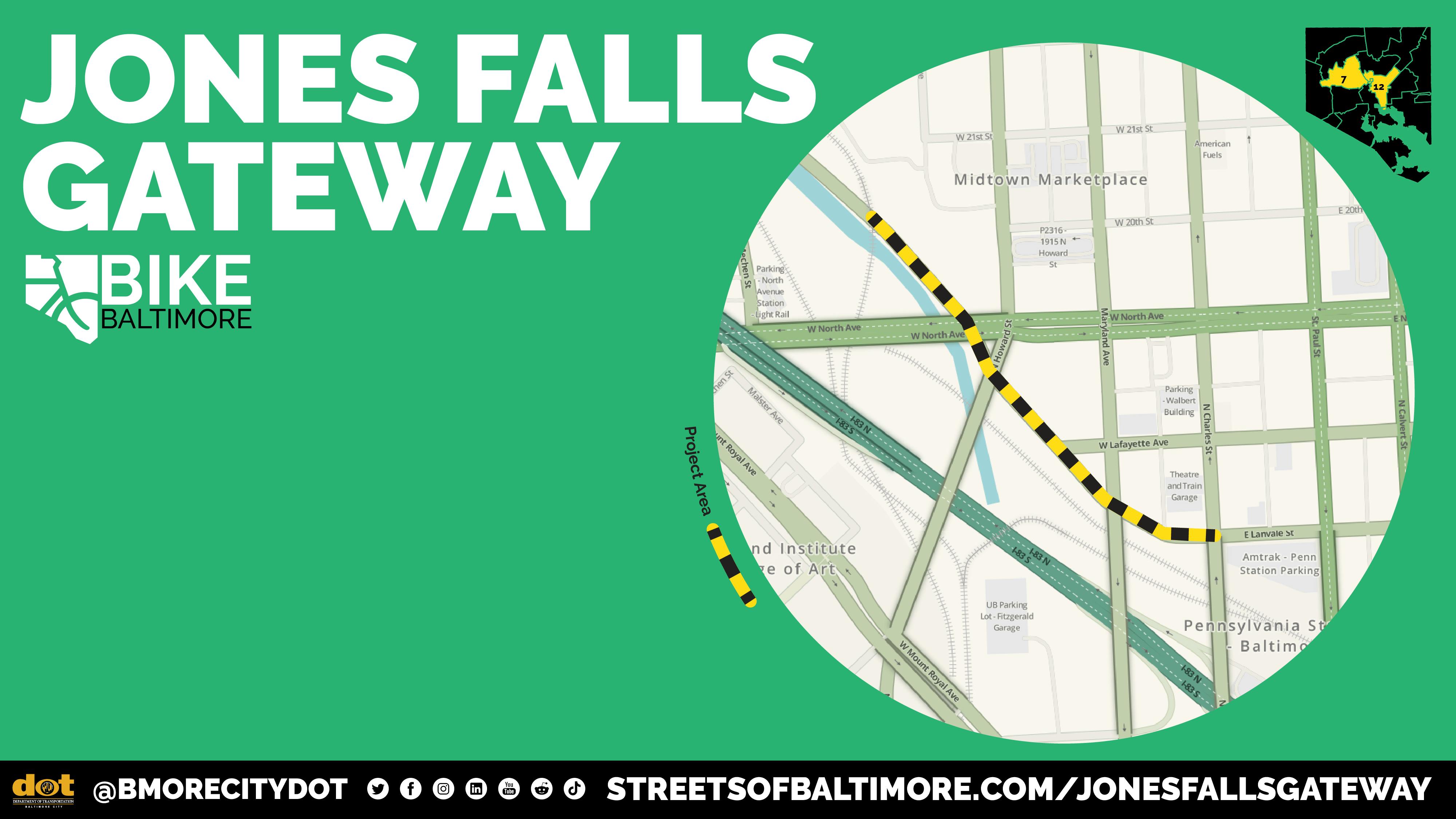
The Jones Falls Gateway Project will turn a narrow, uneven sidewalk along Falls Road and Lanvale Street into a wide, shared-use path—connecting people of all ages to Penn Station and Druid Hill Park with safer, greener infrastructure. This project will address a gap in the trail network, creating a continuous and accessible Jones Falls Trail as it approaches Penn Station.
This infrastructure upgrade is part of the broader Falls Gateway Master Plan, which also includes bridge lighting, public art activations, and alleyway improvements being developed by MICA, Midtown, and Friends of the Jones Falls.
A design alternatives presentation will be held on January 15, 2026 from 6:30 to 8 p.m. at the Auditorium in MICA Fred Lazarus IV Center, Office of Graduate Studies (131 W North Ave, Baltimore, MD 21201).
Engineering design is estimated to be completed by summer 2026.
Learn more about the project and sign up for updates here.
|
|
|
|
|
|
|
Attend the Howard County Transportation Open House on January 29

The third annual Howard County Transportation Open House will be held Thursday, January 29, 2026 from 4:30 - 7:30 p.m. at Wilde Lake High School in Columbia (5460 Trumpeter Road, Columbia, MD 21044). Topics will include active transportation and transportation safety, among many more. The Open House will provide the public with an opportunity to comment on the County's overall transportation priorities, approaches to solving common transportation challenges, and specific projects.
Baltimore Metropolitan Council staff will be in attendance to share information about regional transportation initiatives.
|
|
|
|
|
|
|
Route 40 Design Manual Open to Comments

In Howard County, Route 40 connects communities from Ellicott City to Catonsville, passing through historic sites and diverse commercial districts.
In 2010 the Route 40 Design Manual laid the groundwork for unified development, but since then Howard County has adopted new policies that call for safer, greener, and more accessible corridors. Now, Howard County is updating their Route 40 Design Manual and asking for feedback to help shape the document.
The update will reexamine zoning, improve pedestrian and bicycle amenities, and weave in public-art and signage concepts that honor Route 40’s cultural heritage. The goal of these enhancements is to boost local businesses, enhance tourism, and create a corridor that is both functionally efficient and visually memorable.
Learn more and tune into the progress at this link. Please send comments or suggestions to planning@howardcountymd.gov, and reference "Route 40 Design Manual" in the subject line.
|
|
|
|
|
|
|
Druid Park Lake Design Survey
Photo: Rendering of future vision for Druid Park Lake
The Druid Lake Vision Plan, launched by Baltimore City Recreation & Parks (BCRP) in 2021, reimagines the city’s historic reservoir as a vibrant public and ecological destination following the relocation of drinking water into underground tanks.
The planning and construction work around Druid Lake brings together efforts by BCRP, the Department of Public Works (DPW), and the Department of Transportation (DOT).
The new design restores the lake’s natural shoreline, improves walking and biking access, and introduces new places for recreation, community programs, and restored ecosystems. For the first time, Baltimoreans will have full public access to the lake’s edge, new on-water programs, and restored natural habitats that connect to the historic stream valley.
The design includes safer, more welcoming crossings across Druid Park Lake Drive, such as a new Eutaw Street Plaza, wider sidewalks, and improved trail links to the historic Madison Gateway at Swann Drive.
A hybrid meeting took place in October 2025. You can review the meeting materials here.
Sign up here to receive updates, meeting invitations, and surveys. Take the community survey at this link to help shape the future of Druid Lake
|
|
|
|
|
|
|
Pedestrian Safety Improvements Coming to Jessup

The Howard County Department of Public Works (DPW) will be implementing flex-post bump outs along Mission Road at the intersection of Redondo Way in Jessup. This intersection is the location of an existing, high-priority crosswalk at the entrance to Guilford Park High School.
The flex-post bump-outs will provide better visibility for pedestrians waiting to cross the road. Additionally, the bump-outs should improve drivers’ sight lines when entering the intersection.
This project will not remove any additional on-street parking, and the ultimate layout will be determined with consideration of large vehicle turning movements through the intersection.
This project is part of Howard County’s ongoing commitment to making safety improvements for pedestrians, cyclists, drivers, and other road users. New requests for safety improvements and traffic calming in Howard County can be shared with DPW at: www.howardcountymd.gov/public-works/traffic-calming.
|
|
|
|
|
|
|
Chinquapin Run Trail Public Meeting February 5
Photo: Project scope for Chinquapin Run Trail
The Chinquapin Run Trail will create a continuous, accessible path along the Chinquapin Run stream between East Lake Avenue and Perring Parkway. The project aims to connect neighborhoods, schools, shopping centers, and recreation areas while improving safety and access for people walking, biking, or taking transit.
When complete, the trail will link Chinquapin Park with surrounding communities, creating new opportunities for recreation, transportation, and connection to nature in northeast Baltimore.
The Baltimore City Department of Transportation (BCDOT) will hold a public meeting on Thursday, February 5, 2026 from 6:30 to 8 p.m. at the Faith Presbyterian Church (5400 Loch Raven Boulevard, Baltimore, MD 21239).
Take this brief survey to share your thoughts on the project. Learn more about the project and sign up for updates here.
|
|
|
|
|
|
|
Harford Road Hardening Phase II Launches
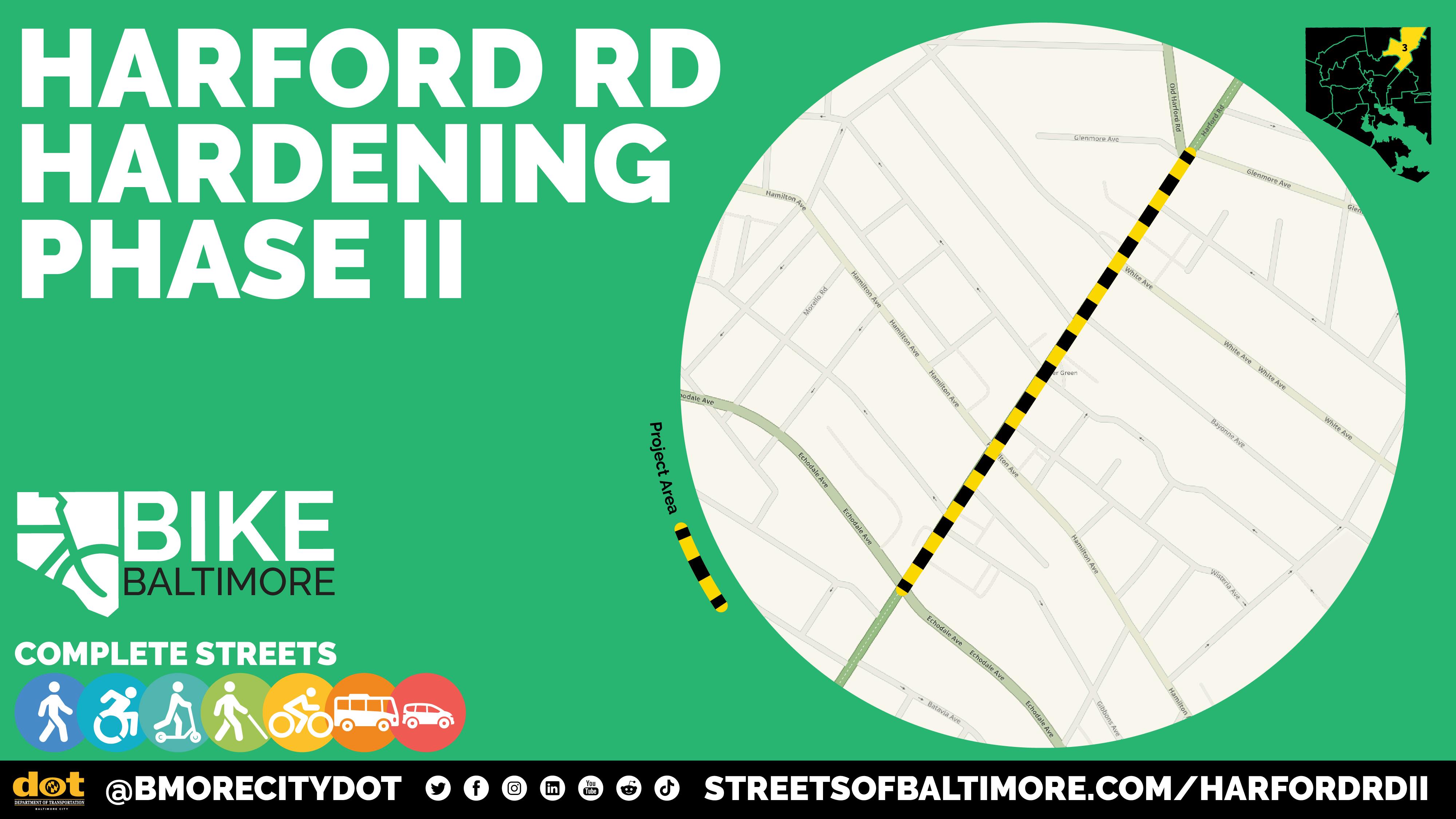
The Baltimore City Department of Transportation (BCDOT) has launched the Harford Road Hardening Phase II project, covering a 0.6-mile stretch of Harford Road between Glenmore Avenue and Echodale Avenue.
This project will upgrade existing quick-build bike lanes into permanent infrastructure, including bike lane-separated bus islands and concrete bus stop pads to improve safety and comfort for people biking and riding transit.
Learn more about the project and sign up for updates here.
|
|
|
|
|
|
|
|
|
|
|


