Public Outreach Session 2 – Port of Fort Pierce Master Plan
Public Outreach Session 2 – Port of Fort Pierce Master Plan
Events
Port of Fort Pierce Master Plan Public Outreach Session 2 - Virtual Webcast - Session 1
Thanks for your interest! Registration is closed because the event has concluded.
THANK YOU TO ALL WHO PARTICIPATED IN PUBLIC ENGAGEMENT SESSIONS 1 AND 2!
If you were not able to participate, explore the results of Engagement Session 2 as well as get up to speed on the results of Public Engagement Session 1. Each virtual meeting session was recorded and available for viewing at the end of this webpage. The base content and presentation was the same for each meeting; audience comments varied. An archive of all previous planning presentations, posters, and materials is also available below.
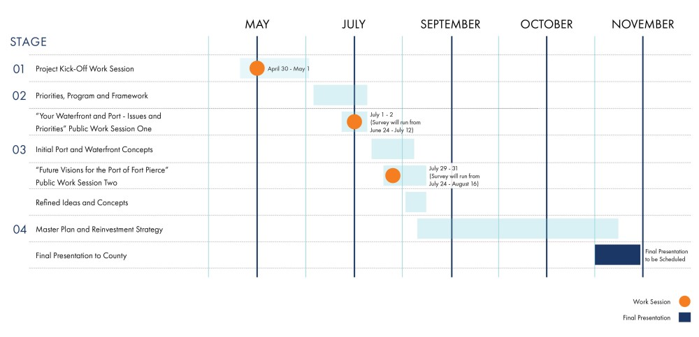
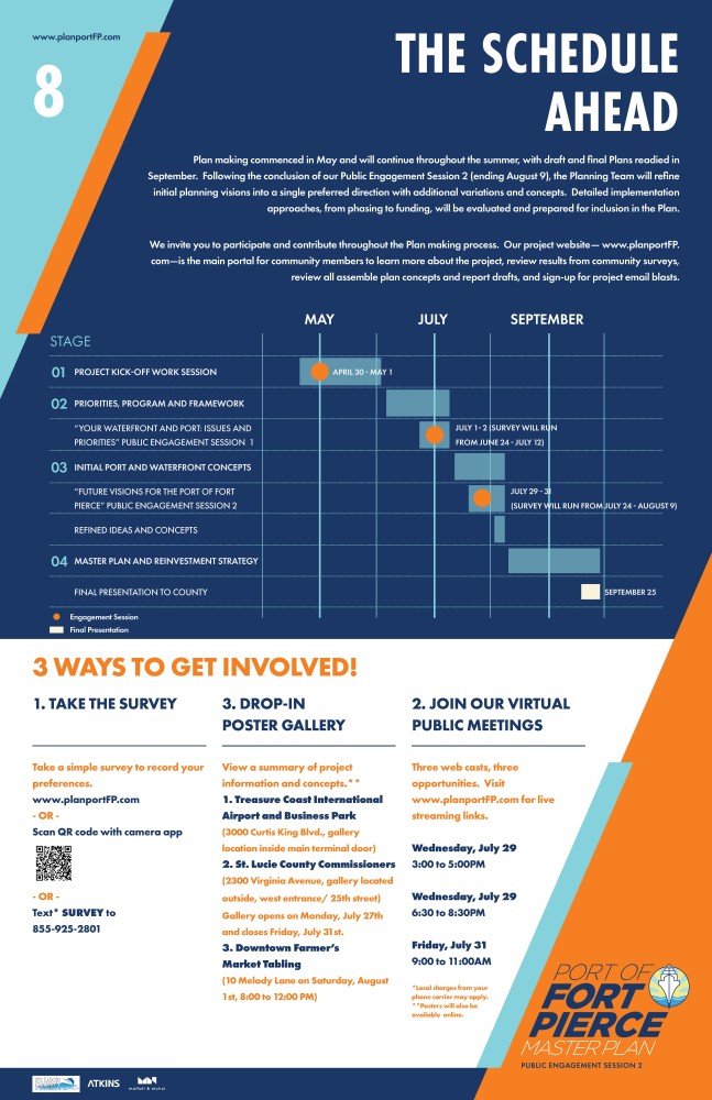
The planning team is working to complete the master plan by early to mid-October. Additional time was added to the process to ensure all of the extensive community outreach collected as part of the process was reviewed and taken into account in the plan.
Have questions or comments you would like addressed by St. Lucie County? Please contact Project Manager Kori Benton (bentonk@stlucieco.org) at any time.
SUBSCRIBE TO RECEIVE THE LATEST PROJECT NEWS
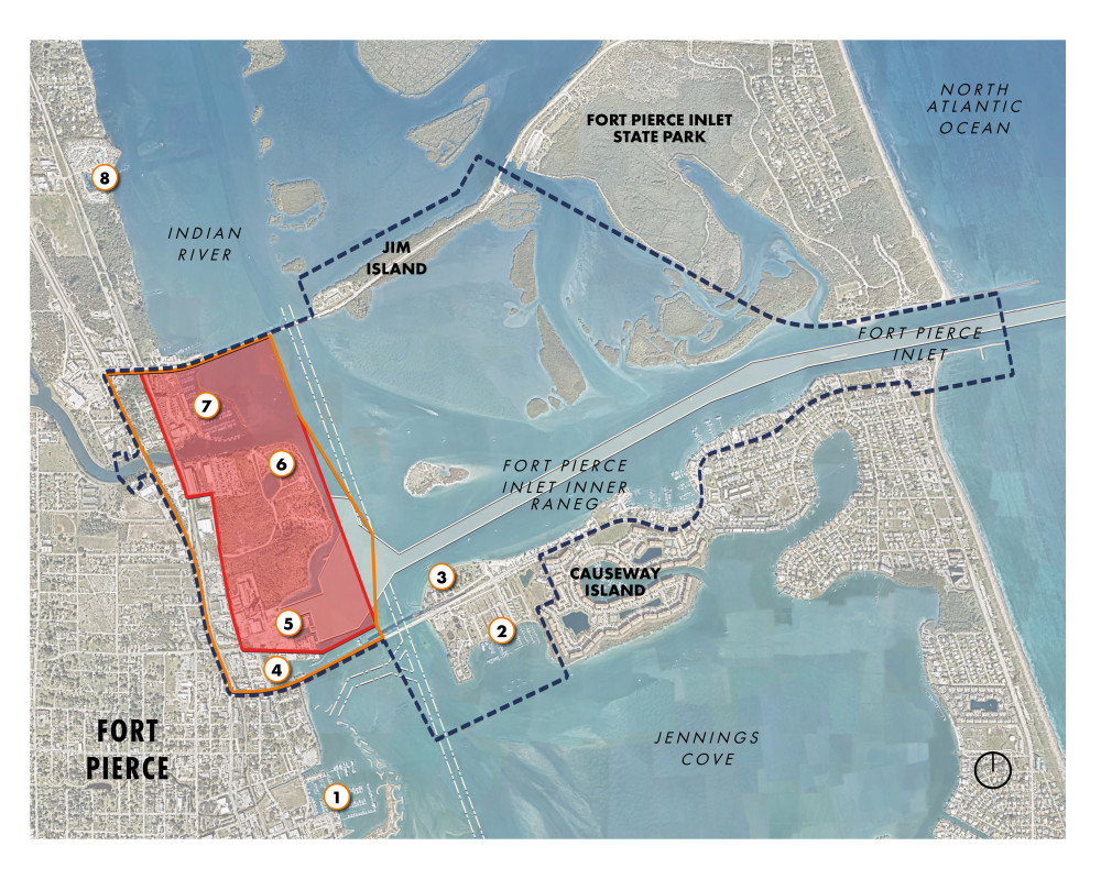
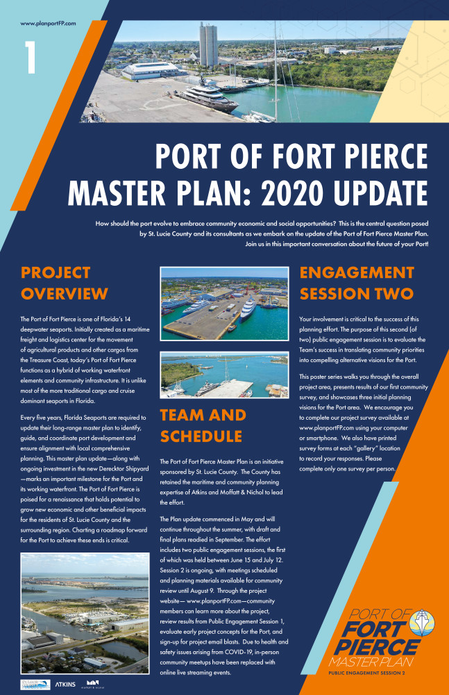
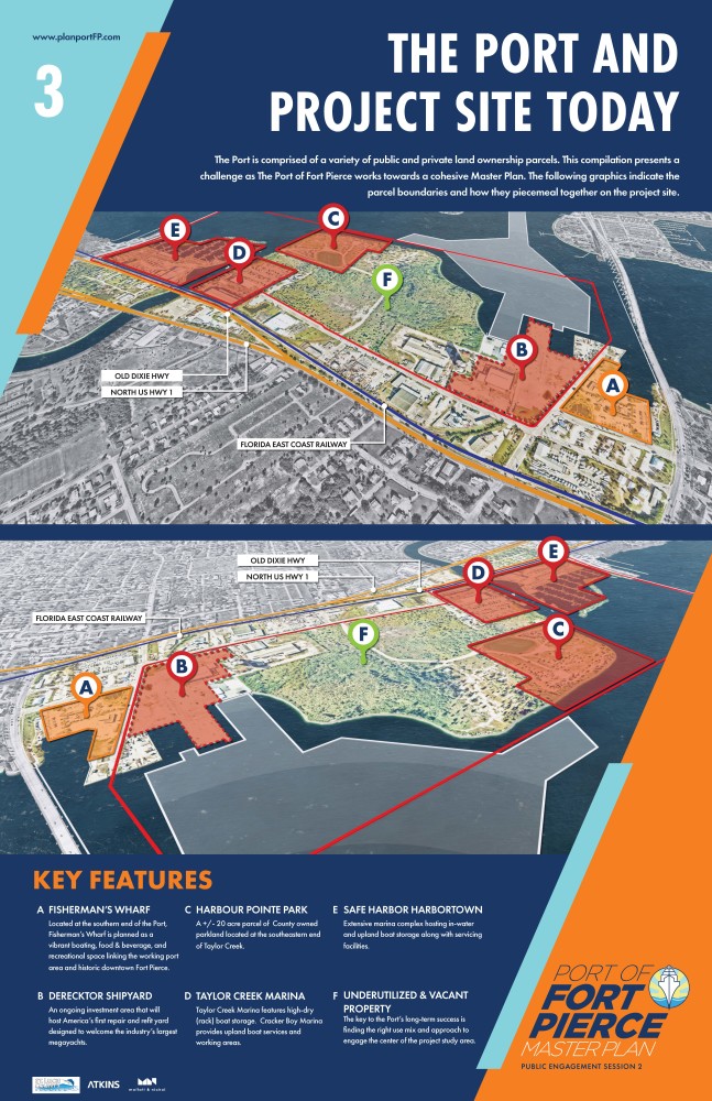
THE PORT AND PROJECT STUDY AREA
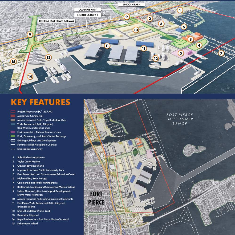
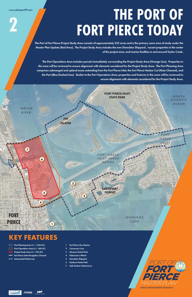
The Port of Fort Pierce is one of Florida’s 14 deep water seaports. Initially created as a maritime freight and logistics center for the movement of Treasure Coast agricultural products and other cargos, today’s Port of Fort Pierce functions as a hybrid of working waterfront elements and community infrastructure. The Project Study Area consists of approximately 255 acres (Red Area). This zone includes the new Derecktor Shipyard (ex-Indian River Terminal), vacant greenfield properties, Harbour Point Park, and marine facilities flanking the mouth of Taylor Creek.
The Port Operations Area (Orange Line) and Port Planning Area (Blue Dashed Line) are also included in the Master Plan update. Parcels, uses, and features found in each will be reviewed to ensure alignment with elements considered for the Project Study Area.
COMMUNITY SURVEY TWO
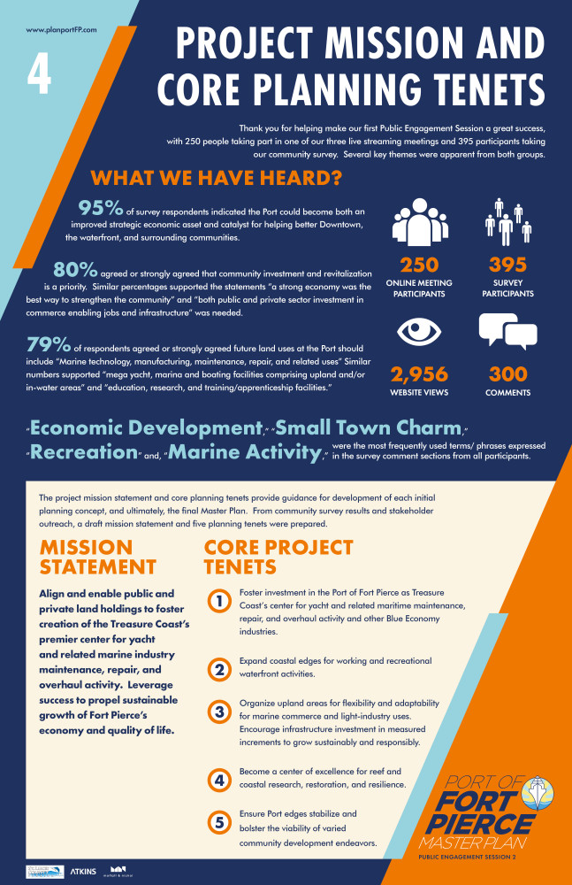
PART 1. DRAFT PROJECT MISSION STATEMENT AND CORE PLANNING TENETS
The project mission statement and core planning tenets provide guidance for development of each initial planning concept, and ultimately, the final Master Plan. From community survey results and stakeholder outreach, a draft mission statement and five planning tenets were prepared. Please review each as part of the questions below.
PART 2. PRELIMINARY CONCEPTS FOR THE PORT OF FORT PIERCE
In Part 2, we present three initial planning concepts. Concepts represent initial thoughts and ideas for reinvisioning the Port of Fort Pierce based on the Community Priorities Survey results and feedback from Public Engagement Session One. Planning concepts were developed using the draft core tenets and framework established for the project area. They also consider the Planning Team's general sense of financial feasibility, ease of implementation, permissibility by regulatory agencies, and community acceptance of project elements.
Please keep in mind that the planning concepts are preliminary and will evolve as the master planning process advances over the coming weeks. Also, many of the ideas can be mixed and matched to form a hybrid of concepts for developed as the preferred direction and ultimate Master Plan.
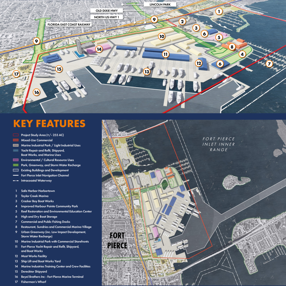
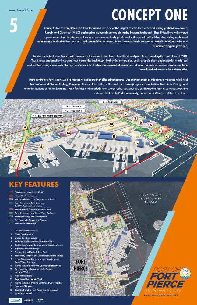
CONCEPT 1
Concept 1 contemplates Port transformation to one of the largest centers for motor and sailing yacht Maintenance, Repair, and Overhaul (MRO) and marine industrial services along the Eastern Seaboard. Ship lift facilities with related open air and high bay (covered) service areas are centrally positioned with specialized buildings for sailing yacht mast maintenance and other functions arrayed around the perimeter. New in-water berths supporting wet slip MRO activities and vessel berthing are envisioned.
Marine industrial warehouses with commercial storefronts line North 2nd Street and parcels surrounding the central yacht MRO. These large and small unit clusters host electronics businesses, hydraulics companies, engine repair, shaft and propeller works, sail makers, technology, research, storage, and a variety of other marine related businesses. A new marine industries education center is introduced adjacent to the existing silos. This facility is integrated with a crew support and amenities zone.
Harbour Pointe Park is renewed to host park and recreational boating features. An anchor tenant of this zone is the expanded Reef Restoration and Marine Ecology Education Center. This facility will include extension programs from Indian River State College and other institutions of higher learning. Park facilities and needed storm water recharge zones are configured to form greenways reaching back into the Lincoln Park Community, Fisherman’s Wharf, and the Downtown Ft. Pierce Waterfront.
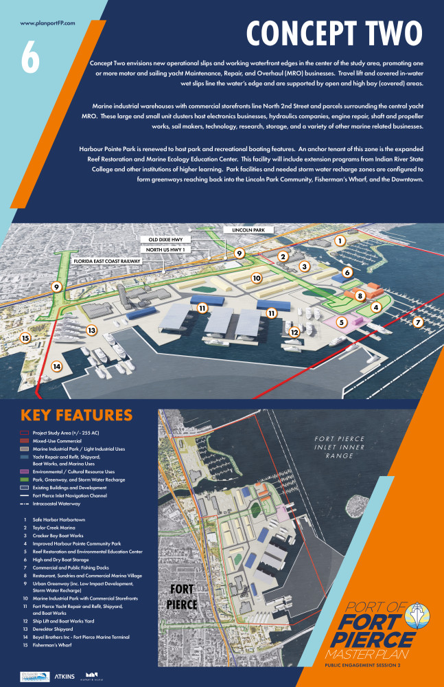
CONCEPT 2
Concept 2 envisions new operational slips and working waterfront edges in the center of the study area, promoting one or more motor and sailing yacht Maintenance, Repair, and Overhaul (MRO) businesses. Travel lift and covered in-water wet slips line the water’s edge and are supported by open and high bay (covered) service areas.
Marine industrial warehouses with commercial storefronts line North 2nd Street and parcels surrounding the central yacht MRO. These large and small unit clusters host electronics businesses, hydraulics companies, engine repair, shaft and propeller works, sail makers, technology, research, storage, and a variety of other marine related businesses.
Harbour Pointe Park is renewed to host park and recreational boating features. An anchor tenant of this zone is the expanded Reef Restoration and Marine Ecology Education Center. This facility will include extension programs from Indian River State College and other institutions of higher learning. Park facilities and needed storm water recharge zones are configured to form greenways reaching back into the Lincoln Park Community, Fisherman’s Wharf, and the Downtown Ft. Pierce Waterfront.
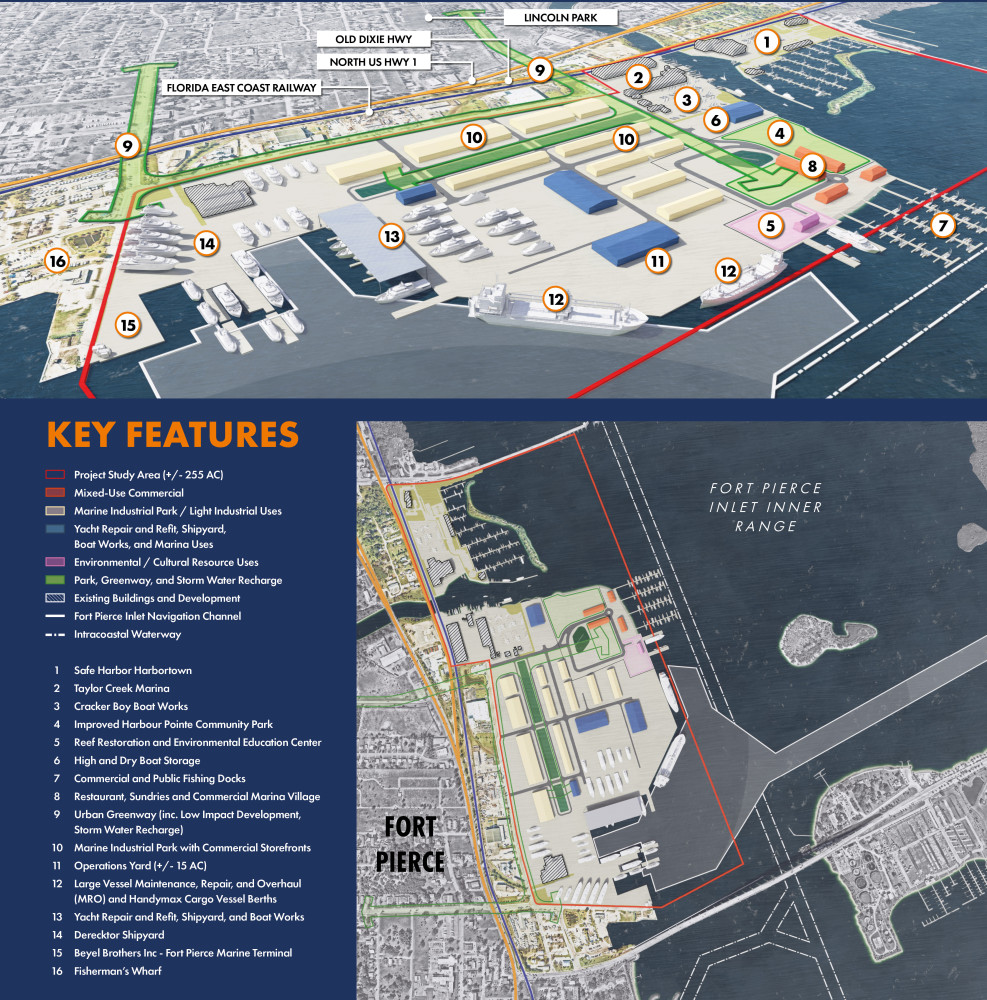
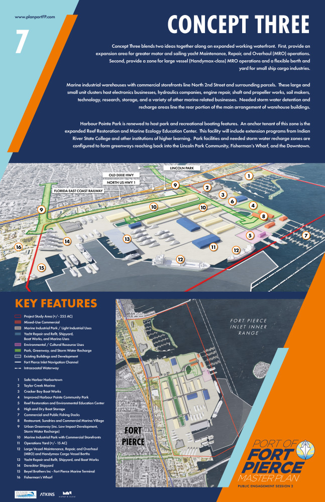
CONCEPT 3
Concept 3 blends two ideas together along an expanded working waterfront. First, provide an expansion area for greater motor and sailing yacht Maintenance, Repair, and Overhaul (MRO) operations. Second, provide a zone for large vessel (Handymax-class) MRO operations and a flexible berth and yard for small ship cargo industries.
Marine industrial warehouses with commercial storefronts line North 2nd Street and surrounding parcels. These large and small unit clusters host electronics businesses, hydraulics companies, engine repair, shaft and propeller works, sail makers, technology, research, storage, and a variety of other marine related businesses. Needed storm water detention and recharge areas line the rear portion of the main arrangement of warehouse buildings.
Harbour Pointe Park is renewed to host park and recreational boating features. An anchor tenant of this zone is the expanded Reef Restoration and Marine Ecology Education Center. This facility will include extension programs from Indian River State College and other institutions of higher learning. Park facilities and needed storm water recharge zones are configured to form greenways reaching back into the Lincoln Park Community, Fisherman’s Wharf, and the Downtown Ft. Pierce Waterfront.
PART 3. DEMOGRAPHIC QUESTIONS
UPCOMING PROJECT LIVE STREAMING EVENTS
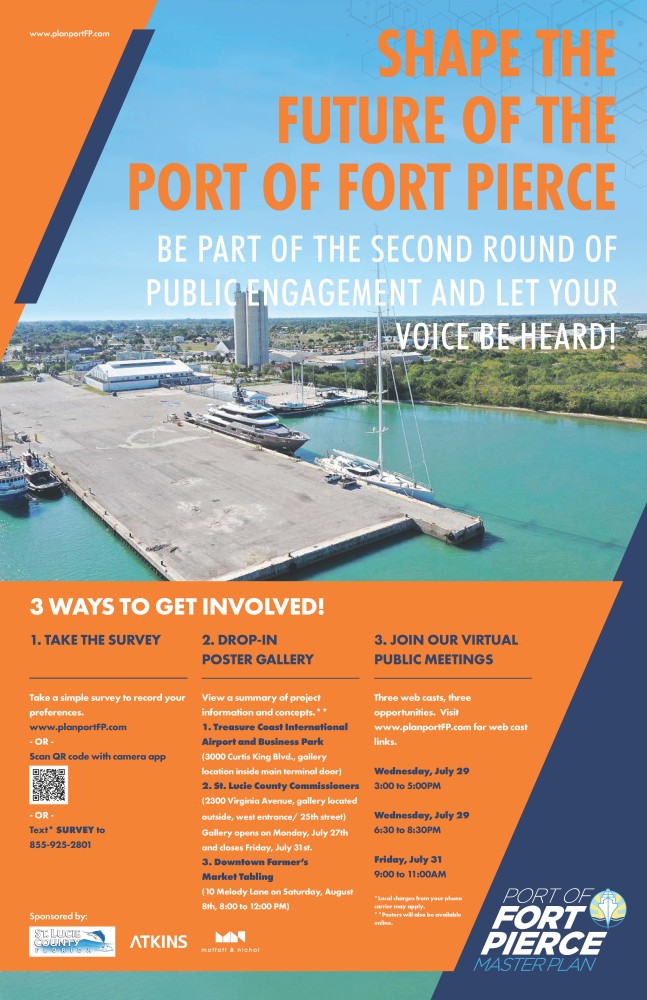
Due to continued health and safety issues arising from COVID-19, in-person community meetups have been replaced with online livestreaming events scheduled for July 29th and 31st.
During these virtual sessions, participants will learn more about the project, review the initial draft concepts in further detail, and ask questions of the consultant team. The established times for these sessions are as follows:
- Session 1 - July 29th from 3:00 to 5:00 PM
- Session 2 - July 29th from 6:30 to 8:30 PM
- Session 3 - July 31st from 9:00 to 11:00 AM
Each event will provide background materials and be logged on the website for community viewing at a later date, along with all other prepared Master Planning materials. Each session will provide the same technical information. Links to log into these events will be provided directly on this project website.
DROP-IN POSTER GALLERY
Live streaming and our online survey may not be convenient or accessible to you. As such, we are providing a Drop-In Poster Gallery for you to view at your leisure at Treasure Coast International Airport and Business Park and St. Lucie County Commissioners. Additionally, County staff will be available to answer questions about the project at the Downtown Farmer's Market Tabling.
This poster series summarizes the overall purpose of the plan, the planning process and its respective milestones, key issues and opportunities, the mission and core tenets, the initial master plan concepts, and other data. There will be hard copies of the survey available for completion and deposit in a review box, with these surveys manually entered into the database and added to all online public feedback.
The locations will be open from 8:00 AM to 5:00 PM, Monday through Friday, with posters exhibited until August 7th.
- Treasure Coast International Airport and Business Park
- 3000 Curtis King Blvd., gallery location inside main terminal door.
- St. Lucie County Commissioners
- 2300 Virginia Avenue., gallery located outside, west entrance/25th street.
- Downtown Farmer's Market Tabling
- 10 Melody Lane on Saturday, July 25th and Saturday, August 8th, from 8:00 AM to 12:00 PM.
RETURN BACK TO THE PROJECT WEBSITE
We will continually update the project website with the latest project information and news. Presentations, archives of webcasts, and other materials will be made available through the project archive portal below. Draft and final versions of the master plan and reinvestment strategy will be assembled during the month of September. The plan will include case study research, concepts, illustrations, strategies and other features that combined will offer community leaders a playback from which to draw upon to guide the future of the Port and its facilities.
If you did not get a chance to review the recorded presentations from Public Work Session One, please watch them here:
https://www.publicinput.com/A782
https://www.publicinput.com/X623
https://www.publicinput.com/J560
Please note they are all the same presentation, but are three different meetings.
AVAILABLE PRESENTATIONS AND DOWNLOADS
Please find below links to master plan posters, presentation, and webcasts. We will continue to add to this archive as materials are prepared, refined, and released.
Documents
Port of Fort Pierce Master Plan Public Outreach Session 2 - Virtual Webcast - Session 3
Thanks for your interest! Registration is closed because the event has concluded.
Port of Fort Pierce Master Plan Public Outreach Session 2 - Virtual Webcast - Session 2
Thanks for your interest! Registration is closed because the event has concluded.