Woodman Drive – Safe Streets for All Project
Woodman Drive – Safe Streets for All Project
THANK YOU FOR VISITING!
UPDATE (June 27, 2025): The survey portion of this Virtual Open House is now closed, and the project team has reviewed all feedback received and considered all input as the final safety plan was formulated. The information presented on this website will continue to be available for review.
SCROLL DOWN TO THE SECTION BELOW TO ENTER THE OPEN HOUSE. SURVEY QUESTIONS ARE INCLUDED ON EACH PAGE.
The City of Riverside is in the early phases of investigating solutions to address traffic and pedestrian safety along Woodman Drive in the corridor north from US 35 to the Riverside city limits north of Springfield Street.
Public input is an important part of developing solution alternatives. We would like to hear from those who live, work, visit and travel through this area. The information we gather through this process will be used to help identify the best solutions.
This survey is the first step in gathering public input. We appreciate those who took the time to complete the survey and sharing their thoughts with us.
The site is organized as a self-guided tour through a series of pages that highlight the issues we are working to address. Begin by reviewing the OVERVIEW discussion in the section below. To advance between pages, click on the CONTINUE button located at the bottom of each page. You can also move back and forth between pages by clicking on the tabs at the top of the discussion section. To see larger versions of an image, simply click on it.
If you need any language translations, click on the TRANSLATE button located near the upper right-hand corner of this page. If you need other interpretation assistance to review these materials and/or provide comment, including printed copies of these materials, please contact the City of Riverside at citymanager@riversideoh.gov or 937-233-1801.
Display boards from the in-person Public Open House on June 4, 2024, are included on this site. This virtual Open House was open 24 hours a day for approximately 30 days. All questions or comments needed to be submitted by July 5, 2024, to be included in the input summary and the final Safety Action Plan.
Questions and comments were welcome to be submitted at the in-person public meeting or the virtual open house or at any time by email, phone or mail to the City of Riverside, citymanager@riversideoh.gov, 937-233-1801, or at 5200 Springfield Street, Suite 100, Riverside, OH 45431. Comments carry equal weight regardless of how they are submitted. All questions and comments received by July 5, 2024 have been compiled and posted on the public input website. Please visit the sidebar to download the summary report and the final Safety Action Plan.
Overview
The Safe Streets for All (SS4A) program is a federally-funded program that provides grants to prevent roadway deaths and serious injuries. In 2023, the City of Riverside was selected by the U.S. Department of Transportation to receive one of these grants. This funding is being used for this project: a study and corridor design along Woodman Drive from Springfield Street to U.S. 35.
This corridor serves as a major thoroughfare connecting schools, residences, employers, retailers, and Wright-Patterson Air Force Base to Riverside and the surrounding region. The City of Riverside has found that there are multiple safety issues along the corridor, including inadequate crosswalks and sidewalks and traffic safety issues leading to vehicular crashes.
This project will develop a design plan to address these multiple safety challenges, while enhancing bicycle, pedestrian, vehicle and transit safety and access throughout the corridor.
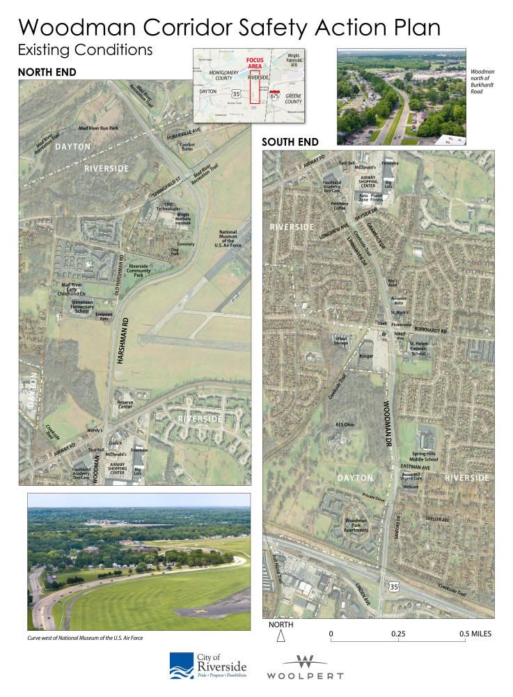
These aerial views of the Woodman Drive Corridor give perspective of the roadway and how it meanders through the City of Riverside. Noted on the maps are businesses and other common destinations for those traveling through and in the Corridor. Throughout this survey site there will be opportunities for you to share how you use the corridor and what improvements you think can be made.
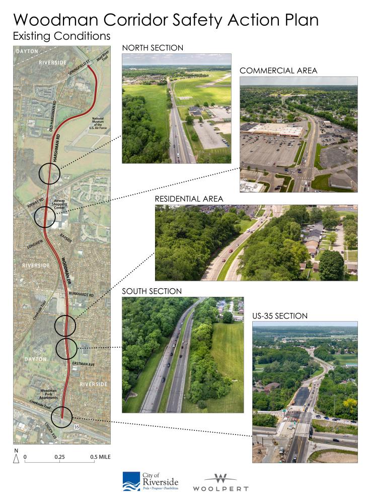
Shown below is the overall map of the Woodman Drive Corridor that is being studied in the SS4A project. Featured are examples of five different ways the roadway is used through the Corridor.
- The north section from Airway Road to Springfield Street adjacent to the Wright-Patterson Air Force Base to the east. Woodman Drive is four lanes with a turn lane in this section.
- The commercial area between Airway Road to Bayside Drive. Currently, the area is vehicle-oriented with limited pedestrian and bicycle access.
- The residential area where the Creekside Trail runs parallel to the west of Woodman Drive for about ¼ of a mile.
- The south section of Woodman Drive where the southbound and northbound lanes are divided by a grassy median. The road is separated from nearby developments by the positioning of the roadway and then connects to a residential area.
- Woodman Drive at US 35, showing the busy exit/entrance ramps and the overpass at US 35.
FINAL PLAN
CONTACT
Josh Rauch
City of Riverside
citymanager@riversideoh.gov
937-233-1801
5200 Springfield Street, Suite
100, Riverside, OH 45431