 Southeast Special Area Study - Phase 3 Survey
Southeast Special Area Study - Phase 3 Survey
Overview
The Southeast Special Area Study is a planning study focused on approximately 18 square miles in southeast Wake County. The study area is in Raleigh’s Urban Service Area, or the area where Raleigh is preparing long-term to serve with City services. The study is focused on land use, transportation, parks, greenways, and urban design. This phase of engagement presents draft recommendations of the study. Your participation will help us refine the recommendations and confirm that these respond to your previous feedback.
View the full summary of draft recommendations.
Community Priorities
Through two rounds of public engagement – held in Summer 2019 and Winter 2020 - we’ve heard several priorities for the study area:
· Protecting the natural resources and rural character of the area.
· Improving travel through the area by car and bike.
· Improving walking in the area.
· Improving access to shopping and other destinations.
The following questions describe the study recommendations and ask if these reflect the study goals.
Step 1
Open Space Preservation
Raleigh currently has recommended future land uses for the study area. These are established in the Future Land Use Map. One proposed change is to the Future Land Use Map near Rock Quarry Road, Whitfield Road, and Auburn Knightdale Road. This change would move mixed-use designations currently on Rock Quarry Road at Auburn Knightdale Road to the intersection with Whitfield Road.
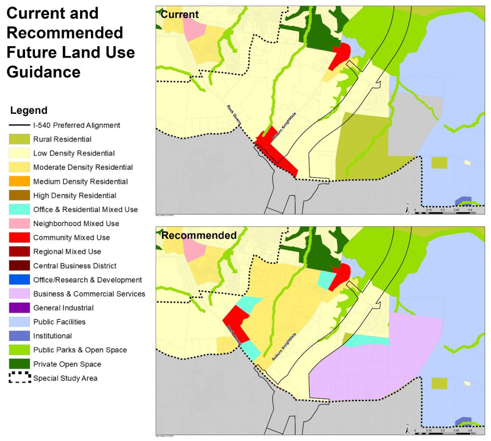
The intent of this recommendation is to address the community’s interest in improving access to shopping and other destinations and to address the community’s interest in preserving the rural character of the area by guiding new development to locate in ‘nodes’ rather than a more dispersed development pattern throughout the area.
To allow for growth, but maintain the area’s rural feel, the recommendations include prioritizing master planning of development and assemblages of parcels. This is instead of piecemeal development that could produce a spread-out and disjointed feel in the area.
The study area is outside of Raleigh city limits and outside of Raleigh extraterritorial jurisdiction (ETJ). The ETJ is the area that has City zoning and the area where property owners can request to annex into Raleigh. City taxes are levied on areas that have been annexed into city limits, a process that is voluntary.
Connectivity
The draft recommendations encourage new street connections in the northwestern portion of the study area between the Neuse River and the future I-540. This is intended to avoid a bottleneck of traffic at any one intersection or road.
The draft recommendations encourage greenways to connect regionally around the study area, including with the nearby towns of Knightdale, Wendell, and Garner.
Natural Resources and Rural Character
The recommendations include “green streets” for new street connections in the study area. Green streets include better spaces to walk and bike and green stormwater infrastructures such as rain gardens and swales. These features reduce stormwater runoff, decrease vehicle speeds, and include a mix of expanded sidewalks, shared-use paths, and bicycle lanes.
The southeast area is a unique area that has valuable natural resources and proximity to amenities and more urban areas. In order to balance these two community priorities, one draft recommendation is to build an overlay zoning district to help. This could be called a ‘Rural Village’ overlay and would allow and encourage compact rural village development that clusters at major intersections.