THANK YOU TO ALL WHO PARTICIPATED IN PUBLIC ENGAGEMENT SESSIONS 1 AND 2! 

If you were not able to participate, explore the results of Engagement Session 2 as well as get up to speed on the results of Public Engagement Session 1.   Each virtual meeting session was recorded and available for viewing at the end of this webpage.  The base content and presentation was the same for each meeting; audience comments varied.  An archive of all previous planning presentations, posters, and materials is also available below.


The planning team is working to complete the master plan by early to mid-October.  Additional time was added to the process to ensure all of the extensive community outreach collected as part of the process was reviewed and taken into account in the plan.       


Have questions or comments you would like addressed by St. Lucie County?  Please contact Project Manager Kori Benton (bentonk@stlucieco.org) at any time.


SUBSCRIBE TO RECEIVE THE LATEST PROJECT NEWS

Question title

*

THE PORT AND PROJECT STUDY AREA

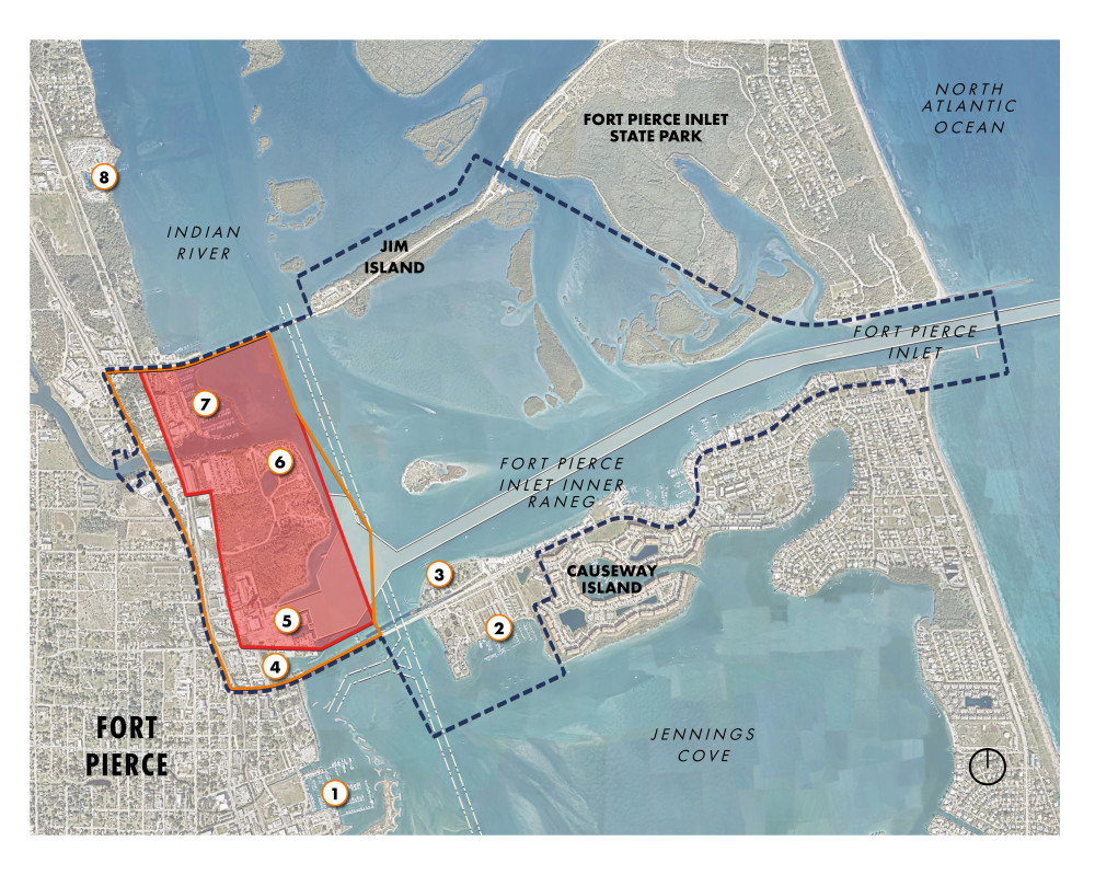
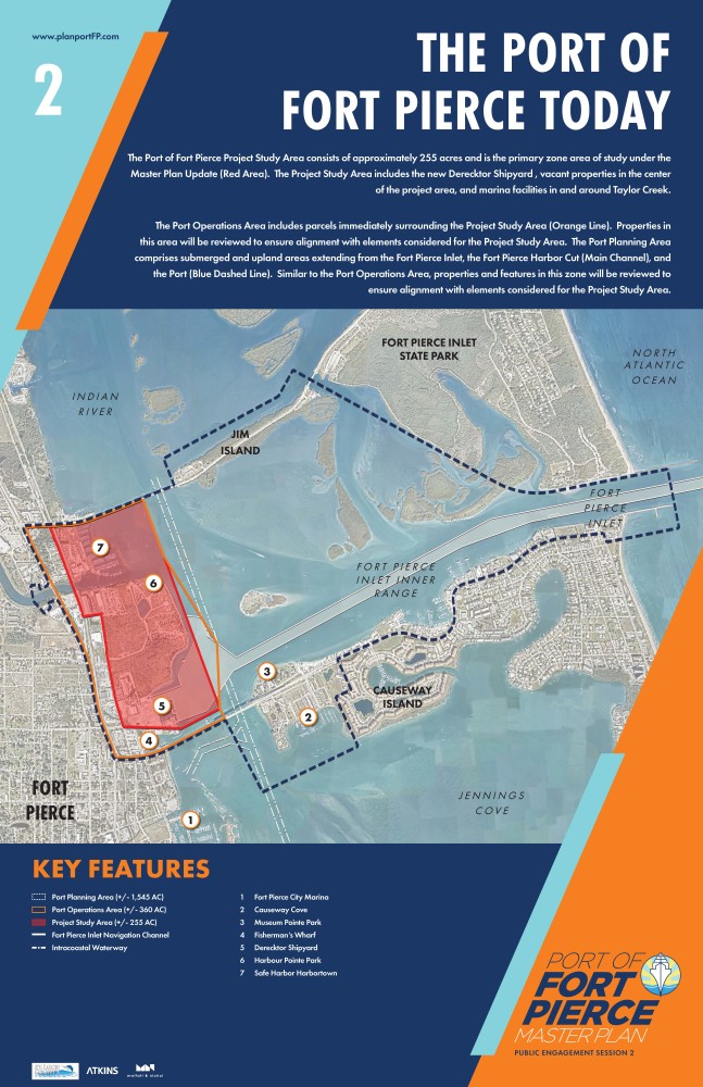
The Port of Fort Pierce is one of Florida’s 14 deep water seaports. Initially created as a maritime freight and logistics center for the movement of Treasure Coast agricultural products and other cargos, today’s Port of Fort Pierce functions as a hybrid of working waterfront elements and community infrastructure.  The Project Study Area consists of approximately 255 acres (Red Area).  This zone includes the new Derecktor Shipyard (ex-Indian River Terminal), vacant greenfield properties, Harbour Point Park, and marine facilities flanking the mouth of Taylor Creek.

The Port Operations Area (Orange Line) and Port Planning Area (Blue Dashed Line) are also included in the Master Plan update.  Parcels, uses, and features found in each will be reviewed to ensure alignment with elements considered for the Project Study Area.


 This image shows the regional context of the Port of Fort Pierce with north orientation. The view extent is from Riverside Marina in the top left, Fort Pierce City Marina in the bottom left, Causeway Island in the lower right, and Fort Pierce Inlet State Park in the top right. Indian River, Fort Pierce Inlet, and Jennings Cove are also called out. The Port Planning Area is demarcated by a dashed navy-blue outline and is approximately 1,546 acres. The Port Operations Area is approximately 258 acres and is represented by an orange boundary. The Port Study Area is approximately 256 acres and is denoted by a red outline with a semitransparent fill.  Moving chronologically through the regional context map, 1. Fort Pierce City Marina, is located in the lower left. 2. Causeway Cove and 3. Museum Point Park are both located on Causeway Island, with Causeway Cove to the south of Seaway Drive, and Museum Point Park to the north of Seaway Drive. 4. Fisherman’s Wharf is located within the Port Operations Area and is south of the Project Study Area. 5. Harbor Pointe Park is located in the northeastern corner of the Project Study Area. 6. Safe Harbor Harbortown is located northwest of Harbor Pointe Park, south of North Causeway and within the Port Operations Area.

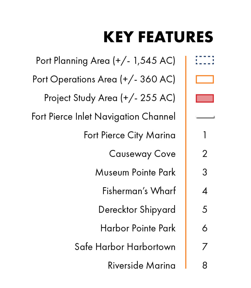
This image shows the legend that accompanies the regional context map. In bold capitalized letters is “KEY FEATURES”. The legend is as follows: Port Planning Area ( /- 1,545 acres) is represented as a navy-blue dashed box.  The Project Operations Area ( /- 360 acres) is represented as an orange solid boundary box.  The Project Study Area ( /- 255 acres) is represented as a red solid box with a semi-transparent red infill. Fort Pierce Inlet Navigation Channel is denoted by a solid white line. 1.	Fort Pierce City Marina 2.	Causeway Cove 3.	Museum Point Park 4.	Fisherman’s Wharf 5.	Derecktor Shipyard 6.	Harbor Pointe Park 7.	Safe Harbor Harbortown 8.	Riverside Marina

COMMUNITY SURVEY TWO 

PART 1.  DRAFT PROJECT MISSION STATEMENT AND CORE PLANNING TENETS 

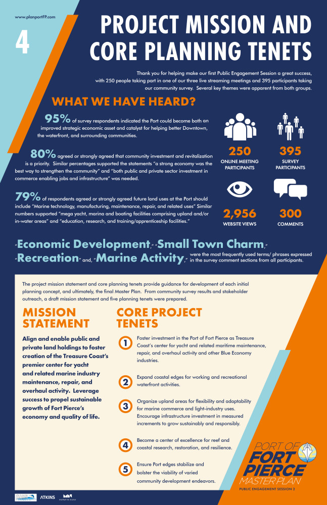
The project mission statement and core planning tenets provide guidance for development of each initial planning concept, and ultimately, the final Master Plan.  From community survey results and stakeholder outreach, a draft mission statement and five planning tenets were prepared.  Please review each as part of the questions below.

Question title

1. The following draft mission statement was prepared for the planning effort.

"Align and enable public and private land holdings to foster creation of the Treasure Coast's premier center for yacht and related marine industry maintenance, repair, and overhaul activity. Leverage success to propel sustainable growth of Fort Pierce's economy and quality of life."

Does this mission statement accurately capture the future direction the Port should take moving forward?
(select one)

Agree
47%
Strongly Agree
24%
Strongly Disagree
10%
Disagree
10%
Neutral
9%
Closed to responses | 155 Responses

Question title

2. How can we improve on this draft mission statement?

Closed for Comments

Question title

3. Five core tenets underpin the draft Mission Statement. How well do each of these tenets align with the draft Mission Statement and your perspective on what is important for the Port moving forward?

Loading question...

PART 2. PRELIMINARY CONCEPTS FOR THE PORT OF FORT PIERCE

In Part 2, we present three initial planning concepts. Concepts represent initial thoughts and ideas for reinvisioning the Port of Fort Pierce based on the Community Priorities Survey results and feedback from Public Engagement Session One. Planning concepts were developed using the draft core tenets and framework established for the project area. They also consider the Planning Team's general sense of financial feasibility, ease of implementation, permissibility by regulatory agencies, and community acceptance of project elements.

Please keep in mind that the planning concepts are preliminary and will evolve as the master planning process advances over the coming weeks.  Also, many of the ideas can be mixed and matched to form a hybrid of concepts for developed as the preferred direction and ultimate Master Plan.  

CONCEPT 1

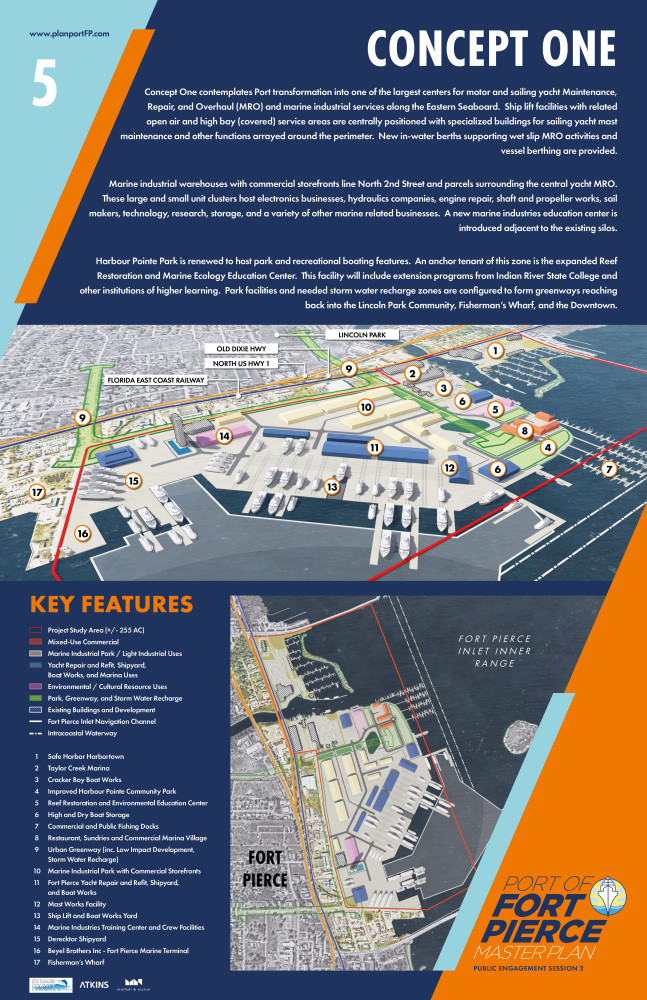
Concept 1 contemplates Port transformation to one of the largest centers for motor and sailing yacht Maintenance, Repair, and Overhaul (MRO) and marine industrial services along the Eastern Seaboard.  Ship lift facilities with related open air and high bay (covered) service areas are centrally positioned with specialized buildings for sailing yacht mast maintenance and other functions arrayed around the perimeter.  New in-water berths supporting wet slip MRO activities and vessel berthing are envisioned. 

Marine industrial warehouses with commercial storefronts line North 2nd Street and parcels surrounding the central yacht MRO.  These large and small unit clusters host electronics businesses, hydraulics companies, engine repair, shaft and propeller works, sail makers, technology, research, storage, and a variety of other marine related businesses.  A new marine industries education center is introduced adjacent to the existing silos.  This facility is integrated with a crew support and amenities zone.

Harbour Pointe Park is renewed to host park and recreational boating features.  An anchor tenant of this zone is the expanded Reef Restoration and Marine Ecology Education Center.  This facility will include extension programs from Indian River State College and other institutions of higher learning.  Park facilities and needed storm water recharge zones are configured to form greenways reaching back into the Lincoln Park Community, Fisherman’s Wharf, and the Downtown Ft. Pierce Waterfront. 


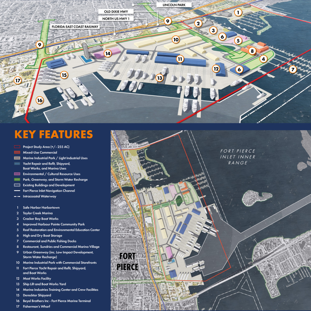
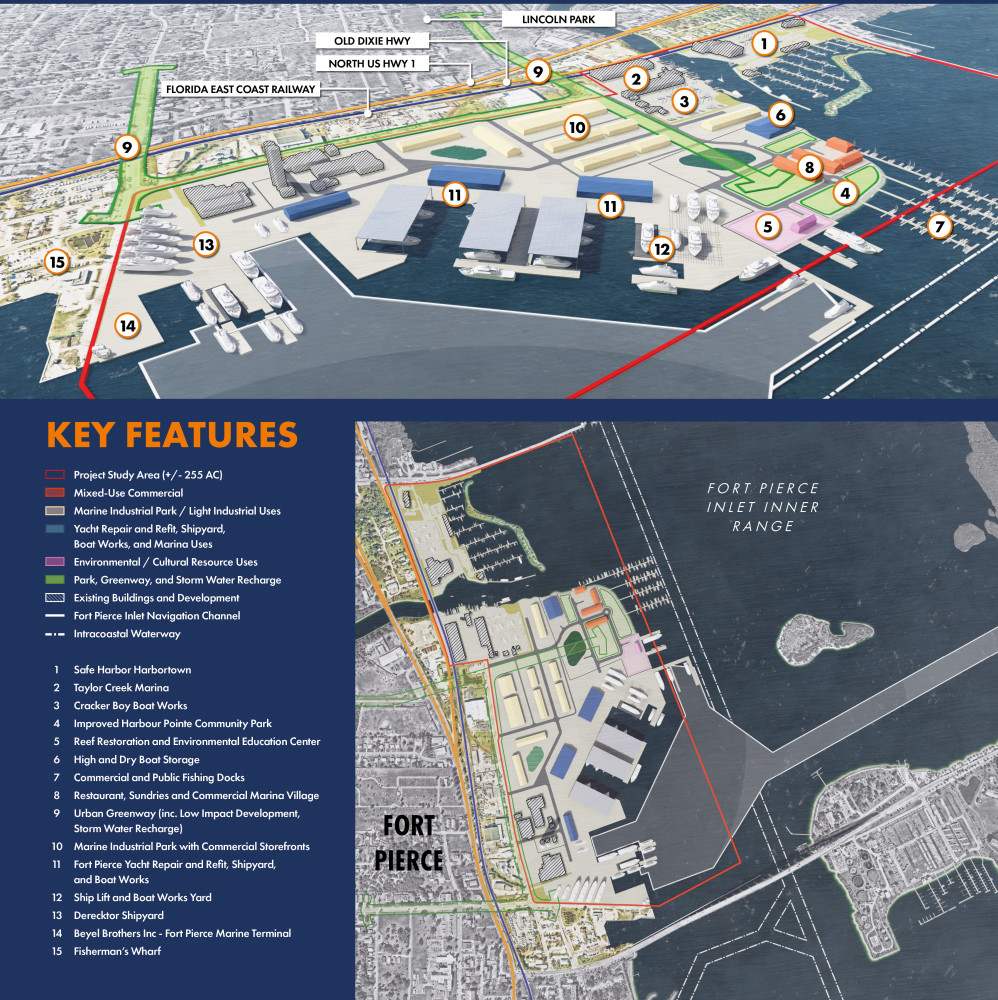
Concept One contemplates Port transformation into one of the largest centers for motor and sailing yacht Maintenance, Repair, and Overhaul (MRO) and marine industrial services along the Eastern Seaboard.  Ship lift facilities with related open air and high bay (covered) service areas are centrally positioned with specialized buildings for sailing yacht mast maintenance and other functions arrayed around the perimeter.  New in-water berths supporting wet slip MRO activities and vessel berthing are provided.   Marine industrial warehouses with commercial storefronts line North 2nd Street and parcels surrounding the central yacht MRO.  These large and small unit clusters host electronics businesses, hydraulics companies, engine repair, shaft and propeller works, sail makers, technology, research, storage, and a variety of other marine related businesses.  A new marine industries education center is introduced adjacent to the existing silos.    Harbour Pointe Park is renewed to host park and recreational boating features.  An anchor tenant of this zone is the expanded Reef Restoration and Marine Ecology Education Center.  This facility will include extension programs from Indian River State College and other institutions of higher learning.  Park facilities and needed storm water recharge zones are configured to form greenways reaching back into the Lincoln Park Community, Fisherman’s Wharf, and the Downtown.   In the middle of the poster is an axonometric view of the project site representing Concept One.  Below this view of the site is the Key Features legend: Project Study Area ( /- 255 AC) is denoted by a red solid boundary Mixed-Use Commercial is represented by an orange fill Marine Industrial Park / Light Industrial Uses is shown as a light cream fill Yacht Repair and Refit, Shipyard, Boat Works, and Marina Uses is represented by a blue fill Environmental / Cultural Resource Uses is denoted by a purple fill Park, Greenway, and Storm Water Recharge is represented by a green fill Existing Buildings and Development is represented by a white diagonal hatch Fort Pierce Inlet Navigation Channel is denoted by a white solid line Intracoastal Waterway is represented by a white dashed line  1.	Safe Harbor Harbortown 2.	Taylor Creek Marina  3.	Cracker Boy Boat Works 4.	Improved Harbour Pointe Community Park 5.	Reef Restoration and Environmental Education Center 6.	High and Dry Boat Storage 7.	Commercial and Public Fishing Docks 8.	Restaurant, Sundries and Commercial Marina Village 9.	Urban Greenway (inc. Low Impact Development, Storm Water Recharge) 10.	Marine Industrial Park with Commercial Storefronts 11.	Fort Pierce Yacht Repair and Refit, Shipyard, and Boat Works 12.	Mast Works Facility 13.	Ship Lift and Boat Works Yard 14.	Marine Industries Training Center and Crew Facilities   15.	Derecktor Shipyard 16.	Beyel Brothers Inc - Fort Pierce Marine Terminal 17.	Fisherman’s Wharf

Question title

4. On a scale of 1 to 5, how well does CONCEPT 1 address the following?

Loading question...

CONCEPT 2

Concept 2 envisions new operational slips and working waterfront edges in the center of the study area, promoting one or more motor and sailing yacht Maintenance, Repair, and Overhaul (MRO) businesses.  Travel lift and covered in-water wet slips line the water’s edge and are supported by open and high bay (covered) service areas.       

Marine industrial warehouses with commercial storefronts line North 2nd Street and parcels surrounding the central yacht MRO.  These large and small unit clusters host electronics businesses, hydraulics companies, engine repair, shaft and propeller works, sail makers, technology, research, storage, and a variety of other marine related businesses. 

Harbour Pointe Park is renewed to host park and recreational boating features.  An anchor tenant of this zone is the expanded Reef Restoration and Marine Ecology Education Center.  This facility will include extension programs from Indian River State College and other institutions of higher learning.  Park facilities and needed storm water recharge zones are configured to form greenways reaching back into the Lincoln Park Community, Fisherman’s Wharf, and the Downtown Ft. Pierce Waterfront.                    

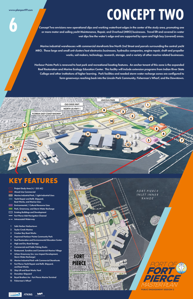
Concept Two envisions new operational slips and working waterfront edges in the center of the study area, promoting one or more motor and sailing yacht Maintenance, Repair, and Overhaul (MRO) businesses.  Travel lift and covered in-water wet slips line the water’s edge and are supported by open and high bay (covered) areas.         Marine industrial warehouses with commercial storefronts line North 2nd Street and parcels surrounding the central yacht MRO.  These large and small unit clusters host electronics businesses, hydraulics companies, engine repair, shaft and propeller works, sail makers, technology, research, storage, and a variety of other marine related businesses.   Harbour Pointe Park is renewed to host park and recreational boating features.  An anchor tenant of this zone is the expanded Reef Restoration and Marine Ecology Education Center.  This facility will include extension programs from Indian River State College and other institutions of higher learning.  Park facilities and needed storm water recharge zones are configured to form greenways reaching back into the Lincoln Park Community, Fisherman’s Wharf, and the Downtown. In the middle of the poster is an axonometric view of the project site representing Concept Two.  Below this view of the site is the Key Features legend: Project Study Area ( /- 255 AC) is denoted by a red solid boundary Mixed-Use Commercial is represented by an orange fill Marine Industrial Park / Light Industrial Uses is shown as a light cream fill Yacht Repair and Refit, Shipyard, Boat Works, and Marina Uses is represented by a blue fill Environmental / Cultural Resource Uses is denoted by a purple fill Park, Greenway, and Storm Water Recharge is represented by a green fill Existing Buildings and Development is represented by a white diagonal hatch Fort Pierce Inlet Navigation Channel is denoted by a white solid line Intracoastal Waterway is represented by a white dashed line  1.	Safe Harbor Harbortown 2.	Taylor Creek Marina  3.	Cracker Boy Boat Works 4.	Improved Harbour Pointe Community Park 5.	Reef Restoration and Environmental Education Center 6.	High and Dry Boat Storage 7.	Commercial and Public Fishing Docks 8.	Restaurant, Sundries and Commercial Marina Village 9.	Urban Greenway (inc. Low Impact Development, Storm Water Recharge) 10.	Marine Industrial Park with Commercial Storefronts 11.	Fort Pierce Yacht Repair and Refit, Shipyard, and Boat Works 12.	Ship Lift and Boat Works Yard 13.	Derecktor Shipyard 14.	Beyel Brothers Inc - Fort Pierce Marine Terminal 15.	Fisherman’s Wharf

Question title

5. On a scale of 1 to 5, how well does CONCEPT 2 address the following?

Loading question...

CONCEPT 3

Concept 3 blends two ideas together along an expanded working waterfront.  First, provide an expansion area for greater motor and sailing yacht Maintenance, Repair, and Overhaul (MRO) operations.  Second, provide a zone for large vessel (Handymax-class) MRO operations and a flexible berth and yard for small ship cargo industries.

Marine industrial warehouses with commercial storefronts line North 2nd Street and surrounding parcels.  These large and small unit clusters host electronics businesses, hydraulics companies, engine repair, shaft and propeller works, sail makers, technology, research, storage, and a variety of other marine related businesses.  Needed storm water detention and recharge areas line the rear portion of the main arrangement of warehouse buildings.

Harbour Pointe Park is renewed to host park and recreational boating features.  An anchor tenant of this zone is the expanded Reef Restoration and Marine Ecology Education Center.  This facility will include extension programs from Indian River State College and other institutions of higher learning.  Park facilities and needed storm water recharge zones are configured to form greenways reaching back into the Lincoln Park Community, Fisherman’s Wharf, and the Downtown Ft. Pierce Waterfront.


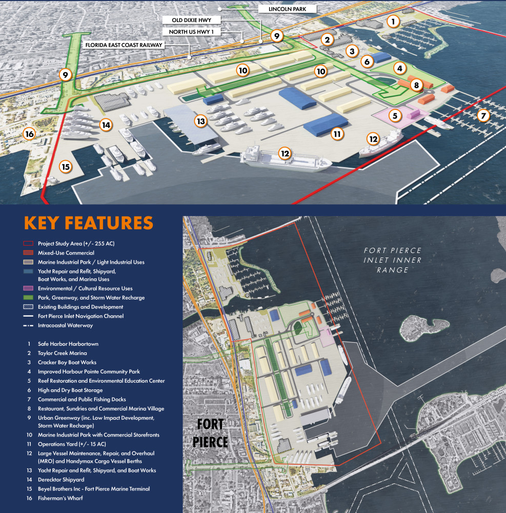
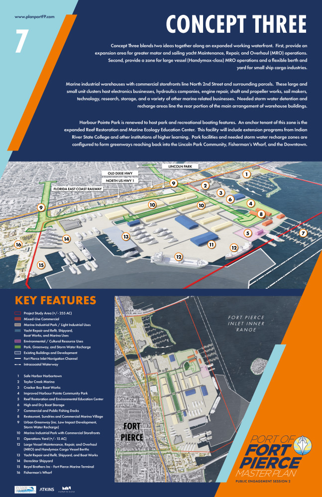
Concept Three blends two ideas together along an expanded working waterfront.  First, provide an expansion area for greater motor and sailing yacht Maintenance, Repair, and Overhaul (MRO) operations. Second, provide a zone for large vessel (Handymax-class) MRO operations and a flexible berth and yard for small ship cargo industries.    Marine industrial warehouses with commercial storefronts line North 2nd Street and surrounding parcels.  These large and small unit clusters host electronics businesses, hydraulics companies, engine repair, shaft and propeller works, sail makers, technology, research, storage, and a variety of other marine related businesses.  Needed storm water detention and recharge areas line the rear portion of the main arrangement of warehouse buildings.    Harbour Pointe Park is renewed to host park and recreational boating features.  An anchor tenant of this zone is the expanded Reef Restoration and Marine Ecology Education Center.  This facility will include extension programs from Indian River State College and other institutions of higher learning.  Park facilities and needed storm water recharge zones are configured to form greenways reaching back into the Lincoln Park Community, Fisherman’s Wharf, and the Downtown. In the middle of the poster is an axonometric view of the project site representing Concept Three.  Below this view of the site is the Key Features legend: Project Study Area ( /- 255 AC) is denoted by a red solid boundary Mixed-Use Commercial is represented by an orange fill Marine Industrial Park / Light Industrial Uses is shown as a light cream fill Yacht Repair and Refit, Shipyard, Boat Works, and Marina Uses is represented by a blue fill Environmental / Cultural Resource Uses is denoted by a purple fill Park, Greenway, and Storm Water Recharge is represented by a green fill Existing Buildings and Development is represented by a white diagonal hatch Fort Pierce Inlet Navigation Channel is denoted by a white solid line Intracoastal Waterway is represented by a white dashed line  1.	Safe Harbor Harbortown 2.	Taylor Creek Marina  3.	Cracker Boy Boat Works 4.	Improved Harbour Pointe Community Park 5.	Reef Restoration and Environmental Education Center 6.	High and Dry Boat Storage 7.	Commercial and Public Fishing Docks 8.	Restaurant, Sundries and Commercial Marina Village 9.	Urban Greenway (inc. Low Impact Development,  10.	Storm Water Recharge) 11.	Marine Industrial Park with Commercial Storefronts 12.	Operations Yard ( /- 15 AC) 13.	Large Vessel Maintenance, Repair, and Overhaul (MRO) and Handymax Cargo Vessel Berths  14.	Yacht Repair and Refit, Shipyard, and Boat Works 15.	Derecktor Shipyard 16.	Beyel Brothers Inc - Fort Pierce Marine Terminal 17.	Fisherman’s Wharf

Question title

6. On a scale of 1 to 5, how well does CONCEPT 3 address the following?

Loading question...

Question title

7. While the Planning Team will make improvements and refinements to all concepts, which initial concept do you feel WILL PROVIDE THE MOST ECONOMIC AND SOCIAL BENEFIT TO YOUR COMMUNITY? (select one)

4. Each have strengths and weaknesses
27%
1. Concept 1
21%
3. Concept 3
20%
2. Concept 2
16%
5. None of the concepts
11%
6. Not sure
5%
Closed to responses | 92 Responses

Question title

8. What big idea(s) would you like to see incorporated into the next iteration of planning concept development?

Closed for Comments

PART 3.  DEMOGRAPHIC QUESTIONS

Question title

9. Did you participate in our previous Community Priorities Survey and/or Public Engagement Session One? (select one)

1. Yes
53%
2. No
41%
3. Not sure
6%
Closed to responses | 90 Responses

Question title

10. What is your age? (select one)

4. 56 to 69
39%
5. 70 or older
29%
3. 40 to 55
16%
2. 18 to 39
15%
1. 17 and under
0%
Closed to responses | 92 Responses

Question title

11. How many people reside in your household? (select one)

1. 0 to 2
67%
2. 3 to 4
25%
3. 5 to 6
8%
4. 7 or more
0%
Closed to responses | 91 Responses

Question title

12. Where do you live?

2. East Ft. Pierce and the Beaches (Zip Codes 34949, 34957)
32%
4. South Ft. Pierce (Zip Code 34982)
17%
5. St. Lucie Village and Northern St. Lucie County (Zip Codes 34946, 34951)
13%
1. Downtown Ft. Pierce (Zip Code 34950)
9%
6. Port St. Lucie (Zip Codes 34952, 34983, 34984, 34986, 34953, 34990, 34987, and 34972)
8%
3. West Ft. Pierce (Zip Codes 34947, 34981, and 34945)
5%
7. Indian River County
5%
8. Martin County
5%
9. Other not listed
5%
Closed to responses | 92 Responses

UPCOMING PROJECT LIVE STREAMING EVENTS

Due to continued health and safety issues arising from COVID-19, in-person community meetups have been replaced with online livestreaming events scheduled for July 29th and 31st.

During these virtual sessions, participants will learn more about the project, review the initial draft concepts in further detail, and ask questions of the consultant team. The established times for these sessions are as follows:

  • Session 1 - July 29th from 3:00 to 5:00 PM
  • Session 2 - July 29th from 6:30 to 8:30 PM
  • Session 3 - July 31st from 9:00 to 11:00 AM

Each event will provide background materials and be logged on the website for community viewing at a later date, along with all other prepared Master Planning materials.  Each session will provide the same technical information.  Links to log into these events will be provided directly on this project website.


DROP-IN POSTER GALLERY

Live streaming and our online survey may not be convenient or accessible to you. As such, we are providing a Drop-In Poster Gallery for you to view at your leisure at Treasure Coast International Airport and Business Park and St. Lucie County Commissioners. Additionally, County staff will be available to answer questions about the project at the Downtown Farmer's Market Tabling.

This poster series summarizes the overall purpose of the plan, the planning process and its respective milestones, key issues and opportunities, the mission and core tenets, the initial master plan concepts, and other data. There will be hard copies of the survey available for completion and deposit in a review box, with these surveys manually entered into the database and added to all online public feedback.

The locations will be open from 8:00 AM to 5:00 PM, Monday through Friday, with posters exhibited until August 7th. 

  • Treasure Coast International Airport and Business Park
    • 3000 Curtis King Blvd., gallery location inside main terminal door.
  • St. Lucie County Commissioners
    • 2300 Virginia Avenue., gallery located outside, west entrance/25th street.
  • Downtown Farmer's Market Tabling
    • 10 Melody Lane on Saturday, July 25th and Saturday, August 8th, from 8:00 AM to 12:00 PM.


RETURN BACK TO THE PROJECT WEBSITE

We will continually update the project website with the latest project information and news. Presentations, archives of webcasts, and other materials will be made available through the project archive portal below. Draft and final versions of the master plan and reinvestment strategy will be assembled during the month of September. The plan will include case study research, concepts, illustrations, strategies and other features that combined will offer community leaders a playback from which to draw upon to guide the future of the Port and its facilities.

If you did not get a chance to review the recorded presentations from Public Work Session One, please watch them here:

https://www.publicinput.com/A782

https://www.publicinput.com/X623

https://www.publicinput.com/J560

Please note they are all the same presentation, but are three different meetings.

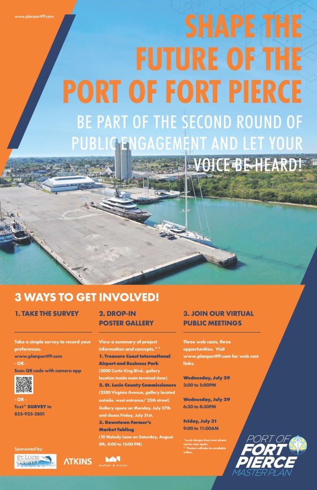
This image is the poster announcement for the second public work session. On the poster, the background image shows an image of the Port of Fort Pierce. It is overlaid with orange and navy-blue diagonal graphics that provide the background for the text to follow. www.planportFP.com, the project website, is stated in the top left corner of the poster graphic. To the right, in large bold capitalized letters, states “SHAPE THE FUTURE OF THE PORT OF FORT PIERCE.” In a slightly smaller font, it states “BE PART OF THE SECOND ROUND OF PUBLIC ENGAGEMENT AND LET YOUR VOICE BE HEARD!”. In the bottom of the image, against an orange background, the following text is stated. 3 WAYS TO GET INVOLVED! 1.	TAKE THE SURVEY  Take a simple survey to record your preferences.  www.planportFP.com, or Scan QR code with camera app, or Text* SURVEY to 855-925-2801.  2.	DROP-IN POSTER GALLERY View a summary of project information and concepts.**   1.	Treasure Coast International Airport and Business Park  (3000 Curtis King Blvd., gallery location inside main terminal door)    2.	St. Lucie County Commissioners  (2300 Virginia Avenue, gallery located outside, west entrance/ 25th street)  Gallery opens on Monday, July 27th and closes Friday, July 31st.   3.	Downtown Farmer’s Market Tabling (10 Melody Lane on Saturday, August 8th, 8:00 to 12:00 PM)   *Local charges from your phone carrier may apply. **Posters will also be available online.  3.	JOIN OUR VIRTUAL PUBLIC MEETINGS Three webcasts, three opportunities. Visit www.planportFP.com for web cast links. Wednesday, July 29, 3:00 to 5:00 PM Wednesday, July 29, 6:30 to 8:30 PM Friday, July 31, 9:00 to 11:00 AM  Sponsored by St. Lucie County, Atkins and Moffatt & Nichol

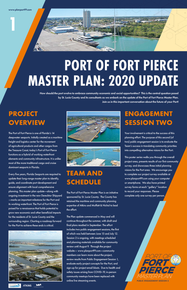
The following poster is the first in an eight poster series. The text is split in 3 columns with a larger header at the top. The graphic is a navy blue background with a light blue triangle shape in the upper left corner and an orange triangle shape in the lower right corner.www.planportFP.com is located in the top left. St. Lucie County, Atkins and Moffatt & Nichol logo are placed in the lower left corner. The text reads as follows: For the header: Port of Fort Pierce Master Plan: 2020 Update How should the port evolve to embrace community economic and social opportunities?  This is the central question posed by St. Lucie County and its consultants as we embark on the update of the Port of Fort Pierce Master Plan. Join us in this important conversation about the future of your Port!  The first column states Project Overview The Port of Fort Pierce is one of Florida’s 14 deepwater seaports. Initially created as a maritime freight and logistics center for the movement of agricultural products and other cargos from the Treasure Coast, today’s Port of Fort Pierce functions as a hybrid of working waterfront elements and community infrastructure. It is unlike most of the more traditional cargo and cruise dominant seaports in Florida. Every five years, Florida Seaports are required to update their long-range master plan to identify, guide, and coordinate port development and ensure alignment with local comprehensive planning. This master plan update—along with ongoing investment in the new Derecktor Shipyard —marks an important milestone for the Port and its working waterfront. The Port of Fort Pierce is poised for a renaissance that holds potential to grow new economic and other beneficial impacts for the residents of St. Lucie County and the surrounding region. Charting a roadmap forward for the Port to achieve these ends is critical. An image of the port is located at the bottom of this column. At the top of column two are two additional photos of the port. The second column states Team and Schedule The Port of Fort Pierce Master Plan is an initiative sponsored by St. Lucie County.  The County has retained the maritime and community planning expertise of Atkins and Moffatt & Nichol to lead the effort.   The Plan update commenced in May and will continue throughout the summer, with draft and final plans readied in September. The effort includes two public engagement sessions, the first of which was held between June 15 and July 12.  Session 2 is ongoing, with meetings scheduled and planning materials available for community review until August 9.  Through the project website— www.planportFP.com—community members can learn more about the project, review results from Public Engagement Session 1, evaluate early project concepts for the Port, and sign-up for project email blasts.  Due to health and safety issues arising from COVID-19, in-person community meetups have been replaced with online live streaming events.   The third column states Engagement Session Two Your involvement is critical to the success of this planning effort. The purpose of this second (of two) public engagement session is to evaluate the Team’s success in translating community priorities into compelling alternative visions for the Port. This poster series walks you through the overall project area, presents results of our first community survey, and showcases three initial planning visions for the Port area.  We encourage you to complete our project survey available at  www.planportFP.com using your computer or smartphone.  We also have printed survey forms at each “gallery” location to record your responses. Please complete only one survey per person.

The following poster is the second in an eight poster series. In the middle of the poster is a graphic of the regional context. The graphic is a navy blue background with a light blue triangle shape in the upper left corner and an orange triangle shape in the lower right corner.www.planportFP.com is located in the top left. St. Lucie County, Atkins and Moffatt & Nichol logo are placed in the lower left corner. The text reads as follows: The Port of Fort Pierce Today The Port of Fort Pierce Project Study Area consists of approximately 255 acres and is the primary zone area of study under the Master Plan Update (Red Area).  The Project Study Area includes the new Derecktor Shipyard , vacant properties in the center of the project area, and marina facilities in and around Taylor Creek. The Port Operations Area includes parcels immediately surrounding the Project Study Area (Orange Line).  Properties in this area will be reviewed to ensure alignment with elements considered for the Project Study Area.  The Port Planning Area comprises submerged and upland areas extending from the Fort Pierce Inlet, the Fort Pierce Harbor Cut (Main Channel), and the Port (Blue Dashed Line).  Similar to the Port Operations Area, properties and features in this zone will be reviewed to ensure alignment with elements considered for the Project Study Area. Below this header text, the project context map is presented. This image shows the regional context of the Port of Fort Pierce with north orientation. The view extent is from Riverside Marina in the top left, Fort Pierce City Marina in the bottom left, Causeway Island in the lower right, and Fort Pierce Inlet State Park in the top right. Indian River, Fort Pierce Inlet, and Jennings Cove are also called out. The Port Planning Area is demarcated by a dashed navy-blue outline and is approximately 1,546 acres. The Port Operations Area is approximately 258 acres and is represented by an orange boundary. The Port Study Area is approximately 256 acres and is denoted by a red outline with a semitransparent fill.  Moving chronologically through the regional context map, 1. Fort Pierce City Marina, is located in the lower left. 2. Causeway Cove and 3. Museum Point Park are both located on Causeway Island, with Causeway Cove to the south of Seaway Drive, and Museum Point Park to the north of Seaway Drive. 4. Fisherman’s Wharf is located within the Port Operations Area and is south of the Project Study Area. 5. Derecktor Shipyard is located in the southern portion of the site, slightly north of Fisherman’s Wharf. 6. Harbor Pointe Park is located in the northeastern corner of the Project Study Area. 7. Safe Harbor Harbortown is located northwest of Harbor Pointe Park, south of North Causeway and within the Port Operations Area.  The legend is as follows: Port Planning Area ( /- 1,545 acres) is represented as a navy-blue dashed box.  The Project Operations Area ( /- 360 acres) is represented as an orange solid boundary box.  The Project Study Area ( /- 255 acres) is represented as a red solid box with a semi-transparent red infill. Fort Pierce Inlet Navigation Channel is denoted by a solid white line. Intracoastal Waterway is denoted by a dashed white line. 1.	Fort Pierce City Marina 2.	Causeway Cove 3.	Museum Point Park 4.	Fisherman’s Wharf 5.	Derecktor Shipyard 6.	Harbor Pointe Park 7.	Safe Harbor Harbortown

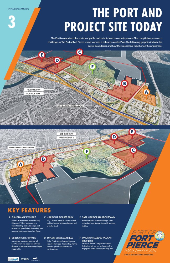
The following poster is the third in an eight poster series. In the middle of the poster is a graphic of the regional context. The graphic is a navy blue background with a light blue triangle shape in the upper left corner and an orange triangle shape in the lower right corner.www.planportFP.com is located in the top left. St. Lucie County, Atkins and Moffatt & Nichol logo are placed in the lower left corner. The text reads as follows: The Port and Project Site Today The Port is comprised of a variety of public and private land ownership parcels. This compilation presents a challenge as The Port of Fort Pierce works towards a cohesive Master Plan. Below are two diagrams of the project site, both represented in an axon view. The top image is the view from the landside, the lower image is the view from the water. Parcel A is denoted by an orange boundary and semi-transparent orange fill. Parcels B, C, D, and E are denoted by a red boundary and semi-transparent red fill. Parcel F is the center of the site, denoted by a lime green callout. Old Dixie Highway and North US Hwy 1 (marked by an orange line), and Florida East Coast Railway (marked by a blue line) are called out on both maps. In the lower portion of the poster, the following key features are called out. These key features correlate to the map exhibits above: A.	FISHERMAN’S WHARF Located at the southern end of the Port, Fisherman’s Wharf is planned as a vibrant boating, food & beverage, and recreational space linking the working port area and historic downtown Fort Pierce. B.	DERECKTOR SHIPYARD An ongoing investment area that will host America’s first repair and refit yard designed to welcome the industry’s largest megayachts. C.	HARBOR POINTE PARK  /- 20 acres of County owned parkland located at the southeastern end of Taylor Creek.   D.	TAYLOR CREEK MARINA Taylor Creek Marina features high-dry (rack) boat storage.  Cracker Boy Marina provides upland boat services and working areas.      E.	SAFE HARBOR HARBORTOWN Extensive marina complex hosting in-water and upland boat storage along with servicing facilities.      F.	UNDERUTILIZED & VACANT PROPERTY The key to the Port’s long-term success is finding the right use mix and approach to engage the center of the project study area.

The following poster is the fourth in an eight poster series. This graphic demonstrates the project mission and core planning tenets. The graphic is a navy blue background with a light blue triangle shape in the upper left corner and an orange triangle shape in the lower right corner.www.planportFP.com is located in the top left. St. Lucie County, Atkins and Moffatt & Nichol logo are placed in the lower left corner. The text reads as follows: Project Mission and Core Planning Tenets Thank you for helping make our first Public Engagement Session a great success, with 250 people taking part in one of our three live streaming meetings and 395 participants taking our community survey.  Several key themes were apparent from both groups. WHAT WE HAVE HEARD? 95% of survey respondents indicated the Port could become both an improved strategic economic asset and catalyst for helping better Downtown, the waterfront, and surrounding communities.   80% agreed or strongly agreed that community investment and revitalization is a priority.  Similar percentages supported the statements “a strong economy was the best way to strengthen the community” and “both public and private sector investment in commerce enabling jobs and infrastructure” was needed. 79% of respondents agreed or strongly agreed future land uses at the Port should include “Marine technology, manufacturing, maintenance, repair, and related uses” Similar numbers supported “mega yacht, marina and boating facilities comprising upland and/or in-water areas” and “education, research, and training/apprenticeship facilities.” To the right of these statistics are a series of icon graphics that show the overall metrics of the last public work session. 250 online meeting participants 395 survey participants 2,956 website views 300 comments Economic development, small town charm, recreation and marine activity were the most frequently used terms/ phrases expressed in the survey comment sections from all participants. In the bottom of the poster against a separate white background, information is presented on the mission statement and core project tenets. The text reads as follows: The project mission statement and core planning tenets provide guidance for development of each initial planning concept, and ultimately, the final Master Plan.  From community survey results and stakeholder outreach, a draft mission statement and five planning tenets were prepared.   Mission Statement Align and enable public and private land holdings to foster creation of the Treasure Coast’s premier center for yacht and related marine industry maintenance, repair, and overhaul activity.  Leverage success to propel sustainable growth of Fort Pierce’s economy and quality of life.   Core Project Tenets 1.	Foster investment in the Port of Fort Pierce as Treasure Coast’s center for yacht and related maritime maintenance, repair, and overhaul activity and other Blue Economy industries. 2.	Expand coastal edges for working and recreational waterfront activities. 3.	Organize upland areas for flexibility and adaptability for marine commerce and light-industry uses. Encourage infrastructure investment in measured increments to grow sustainably and responsibly.   4.	Become a center of excellence for reef and coastal research, restoration, and resilience. 5.	Ensure Port edges stabilize and bolster the viability of varied community development endeavors.

The following poster is the fifth in an eight poster series. This graphic demonstrates concept one. The graphic is a navy blue background with a light blue triangle shape in the upper left corner and an orange triangle shape in the lower right corner.www.planportFP.com is located in the top left. St. Lucie County, Atkins and Moffatt & Nichol logo are placed in the lower left corner. The text reads as follows: Concept One Concept One contemplates Port transformation into one of the largest centers for motor and sailing yacht Maintenance, Repair, and Overhaul (MRO) and marine industrial services along the Eastern Seaboard.  Ship lift facilities with related open air and high bay (covered) service areas are centrally positioned with specialized buildings for sailing yacht mast maintenance and other functions arrayed around the perimeter.  New in-water berths supporting wet slip MRO activities and vessel berthing are provided.   Marine industrial warehouses with commercial storefronts line North 2nd Street and parcels surrounding the central yacht MRO.  These large and small unit clusters host electronics businesses, hydraulics companies, engine repair, shaft and propeller works, sail makers, technology, research, storage, and a variety of other marine related businesses.  A new marine industries education center is introduced adjacent to the existing silos.    Harbour Pointe Park is renewed to host park and recreational boating features.  An anchor tenant of this zone is the expanded Reef Restoration and Marine Ecology Education Center.  This facility will include extension programs from Indian River State College and other institutions of higher learning.  Park facilities and needed storm water recharge zones are configured to form greenways reaching back into the Lincoln Park Community, Fisherman’s Wharf, and the Downtown.   In the middle of the poster is an axonometric view of the project site representing Concept One.  Below this view of the site is the Key Features legend: Project Study Area ( /- 255 AC) is denoted by a red solid boundary Mixed-Use Commercial is represented by an orange fill Marine Industrial Park / Light Industrial Uses is shown as a light cream fill Yacht Repair and Refit, Shipyard, Boat Works, and Marina Uses is represented by a blue fill Environmental / Cultural Resource Uses is denoted by a purple fill Park, Greenway, and Storm Water Recharge is represented by a green fill Existing Buildings and Development is represented by a white diagonal hatch Fort Pierce Inlet Navigation Channel is denoted by a white solid line Intracoastal Waterway is represented by a white dashed line  1.	Safe Harbor Harbortown 2.	Taylor Creek Marina  3.	Cracker Boy Boat Works 4.	Improved Harbour Pointe Community Park 5.	Reef Restoration and Environmental Education Center 6.	High and Dry Boat Storage 7.	Commercial and Public Fishing Docks 8.	Restaurant, Sundries and Commercial Marina Village 9.	Urban Greenway (inc. Low Impact Development, Storm Water Recharge) 10.	Marine Industrial Park with Commercial Storefronts 11.	Fort Pierce Yacht Repair and Refit, Shipyard, and Boat Works 12.	Mast Works Facility 13.	Ship Lift and Boat Works Yard 14.	Marine Industries Training Center and Crew Facilities   15.	Derecktor Shipyard 16.	Beyel Brothers Inc - Fort Pierce Marine Terminal 17.	Fisherman’s Wharf To the right of the legend is a plan view of the site.

The following poster is the sixth in an eight poster series. This graphic demonstrates concept two. The graphic is a navy blue background with a light blue triangle shape in the upper left corner and an orange triangle shape in the lower right corner.www.planportFP.com is located in the top left. St. Lucie County, Atkins and Moffatt & Nichol logo are placed in the lower left corner. The text reads as follows: Concept Two Concept Two envisions new operational slips and working waterfront edges in the center of the study area, promoting one or more motor and sailing yacht Maintenance, Repair, and Overhaul (MRO) businesses.  Travel lift and covered in-water wet slips line the water’s edge and are supported by open and high bay (covered) areas.         Marine industrial warehouses with commercial storefronts line North 2nd Street and parcels surrounding the central yacht MRO.  These large and small unit clusters host electronics businesses, hydraulics companies, engine repair, shaft and propeller works, sail makers, technology, research, storage, and a variety of other marine related businesses.   Harbour Pointe Park is renewed to host park and recreational boating features.  An anchor tenant of this zone is the expanded Reef Restoration and Marine Ecology Education Center.  This facility will include extension programs from Indian River State College and other institutions of higher learning.  Park facilities and needed storm water recharge zones are configured to form greenways reaching back into the Lincoln Park Community, Fisherman’s Wharf, and the Downtown. In the middle of the poster is an axonometric view of the project site representing Concept Two.  Below this view of the site is the Key Features legend: Project Study Area ( /- 255 AC) is denoted by a red solid boundary Mixed-Use Commercial is represented by an orange fill Marine Industrial Park / Light Industrial Uses is shown as a light cream fill Yacht Repair and Refit, Shipyard, Boat Works, and Marina Uses is represented by a blue fill Environmental / Cultural Resource Uses is denoted by a purple fill Park, Greenway, and Storm Water Recharge is represented by a green fill Existing Buildings and Development is represented by a white diagonal hatch Fort Pierce Inlet Navigation Channel is denoted by a white solid line Intracoastal Waterway is represented by a white dashed line  1.	Safe Harbor Harbortown 2.	Taylor Creek Marina  3.	Cracker Boy Boat Works 4.	Improved Harbour Pointe Community Park 5.	Reef Restoration and Environmental Education Center 6.	High and Dry Boat Storage 7.	Commercial and Public Fishing Docks 8.	Restaurant, Sundries and Commercial Marina Village 9.	Urban Greenway (inc. Low Impact Development, Storm Water Recharge) 10.	Marine Industrial Park with Commercial Storefronts 11.	Fort Pierce Yacht Repair and Refit, Shipyard, and Boat Works 12.	Ship Lift and Boat Works Yard 13.	Derecktor Shipyard 14.	Beyel Brothers Inc - Fort Pierce Marine Terminal 15.	Fisherman’s Wharf To the right of the legend is a plan view of the site.

The following poster is the seventh in an eight poster series. This graphic demonstrates concept three. The graphic is a navy blue background with a light blue triangle shape in the upper left corner and an orange triangle shape in the lower right corner.www.planportFP.com is located in the top left. St. Lucie County, Atkins and Moffatt & Nichol logo are placed in the lower left corner. The text reads as follows: Concept Three Concept Three blends two ideas together along an expanded working waterfront.  First, provide an expansion area for greater motor and sailing yacht Maintenance, Repair, and Overhaul (MRO) operations. Second, provide a zone for large vessel (Handymax-class) MRO operations and a flexible berth and yard for small ship cargo industries.    Marine industrial warehouses with commercial storefronts line North 2nd Street and surrounding parcels.  These large and small unit clusters host electronics businesses, hydraulics companies, engine repair, shaft and propeller works, sail makers, technology, research, storage, and a variety of other marine related businesses.  Needed storm water detention and recharge areas line the rear portion of the main arrangement of warehouse buildings.    Harbour Pointe Park is renewed to host park and recreational boating features.  An anchor tenant of this zone is the expanded Reef Restoration and Marine Ecology Education Center.  This facility will include extension programs from Indian River State College and other institutions of higher learning.  Park facilities and needed storm water recharge zones are configured to form greenways reaching back into the Lincoln Park Community, Fisherman’s Wharf, and the Downtown. In the middle of the poster is an axonometric view of the project site representing Concept Three.  Below this view of the site is the Key Features legend: Project Study Area ( /- 255 AC) is denoted by a red solid boundary Mixed-Use Commercial is represented by an orange fill Marine Industrial Park / Light Industrial Uses is shown as a light cream fill Yacht Repair and Refit, Shipyard, Boat Works, and Marina Uses is represented by a blue fill Environmental / Cultural Resource Uses is denoted by a purple fill Park, Greenway, and Storm Water Recharge is represented by a green fill Existing Buildings and Development is represented by a white diagonal hatch Fort Pierce Inlet Navigation Channel is denoted by a white solid line Intracoastal Waterway is represented by a white dashed line  1.	Safe Harbor Harbortown 2.	Taylor Creek Marina  3.	Cracker Boy Boat Works 4.	Improved Harbour Pointe Community Park 5.	Reef Restoration and Environmental Education Center 6.	High and Dry Boat Storage 7.	Commercial and Public Fishing Docks 8.	Restaurant, Sundries and Commercial Marina Village 9.	Urban Greenway (inc. Low Impact Development,  10.	Storm Water Recharge) 11.	Marine Industrial Park with Commercial Storefronts 12.	Operations Yard ( /- 15 AC) 13.	Large Vessel Maintenance, Repair, and Overhaul (MRO) and Handymax Cargo Vessel Berths  14.	Yacht Repair and Refit, Shipyard, and Boat Works 15.	Derecktor Shipyard 16.	Beyel Brothers Inc - Fort Pierce Marine Terminal 17.	Fisherman’s Wharf  To the right of the legend is a plan view of the site.

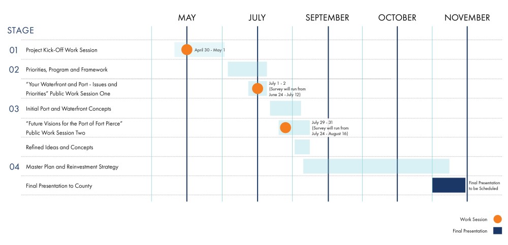
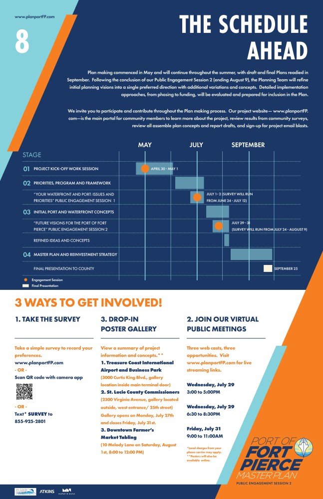
The following poster is the last in an eight poster series. This graphic demonstrates the schedule ahead. The graphic is a navy blue background with a light blue triangle shape in the upper left corner and an orange triangle shape in the lower right corner.www.planportFP.com is located in the top left. St. Lucie County, Atkins and Moffatt & Nichol logo are placed in the lower left corner. The text reads as follows: The Schedule Ahead Plan making commenced in May and will continue throughout the summer, with draft and final Plans readied in September.  Following the conclusion of our Public Engagement Session 2 (ending August 9), the Planning Team will refine initial planning visions into a single preferred direction with additional variations and concepts.  Detailed implementation approaches, from phasing to funding will be evaluated and prepared for inclusion in the Plan.     We invite you to participate and contribute throughout the Plan making process. Our project website—  www.planportFP.com—is the main portal for community members to learn more about the project, review results from community surveys, review all assemble plan concepts and report drafts, and sign-up for project email blasts. This image indicates the overall timeline for the project schedule, as represented by a series of bars indicating time periods and a series of orange circles indicating when work sessions occur in the project schedule. The Port of Fort Pierce Master Plan and Reinvestment Strategy will begin in late April and end in late September. The project is broken down into 4 stages, as described below. Stage 1 is Project Kick-Off Work Session held on April 30 to May 1. Stage 1 will run from late April to early June. Stage 2 is Priorities, Program and Framework, and will run from early June to early July. Public Work Session One will consist of a public engagement period and survey running from June 24 to July 12. Live, virtual meetings will occur on July 1 and 2. Stage 3 is Initial Port and Waterfront Concepts and will run from early July to early August. Public Work Session Two will consist of a public engagement period and survey running from July 22 to August 9. Live, virtual meetings will occur on July 29 and 30. Refined Ideas and Concepts will occur during the beginning of August. Stage 4 is Master Plan and Reinvestment Strategy and will run from early August until September 25. A final presentation to County will occur on September 25. In the bottom of the image, against a white background, the following text is stated. 3 WAYS TO GET INVOLVED! 1.	TAKE THE SURVEY  Take a simple survey to record your preferences.  www.planportFP.com, or Scan QR code with camera app, or Text* SURVEY to 855-925-2801.  2.	DROP-IN POSTER GALLERY View a summary of project information and concepts.**  1. Treasure Coast International  Airport and Business Park  (3000 Curtis King Blvd., gallery location inside main terminal door)   2. St. Lucie County Commissioners (2300 Virginia Avenue, gallery located outside, west entrance/ 25th street) Gallery opens on Monday, July 27th and closes Friday, July 31st.   3. Downtown Farmer’s  Market Tabling  (10 Melody Lane on Saturday, August 1st, 8:00 to 12:00 PM)  3.	JOIN OUR VIRTUAL PUBLIC MEETINGS Three webcasts, three opportunities. Visit www.planportFP.com for web cast links. Wednesday, July 29, 3:00 to 5:00 PM Wednesday, July 29, 6:30 to 8:30 PM Friday, July 31, 9:00 to 11:00 AM  *Local charges from your phone carrier may apply. **Posters will also be available online.  Sponsored by St. Lucie County, Atkins and Moffatt & Nichol

AVAILABLE PRESENTATIONS AND DOWNLOADS

Please find below links to master plan posters, presentation, and webcasts.  We will continue to add to this archive as materials are prepared, refined, and released.