Edited for clarity on 8.21.21. The following map represents a combination of the preferences stated by participants (during Phase Soon) relative to where they said they would accept different types of development, and relative to where and how the greatest amount of affordable housing can be provided given the level of planned road and other infrastructure.  Please indicate your level of support for the recommendations for the red, orange, and yellow areas. Click to make the map larger.

Dix Edge Land Use Map

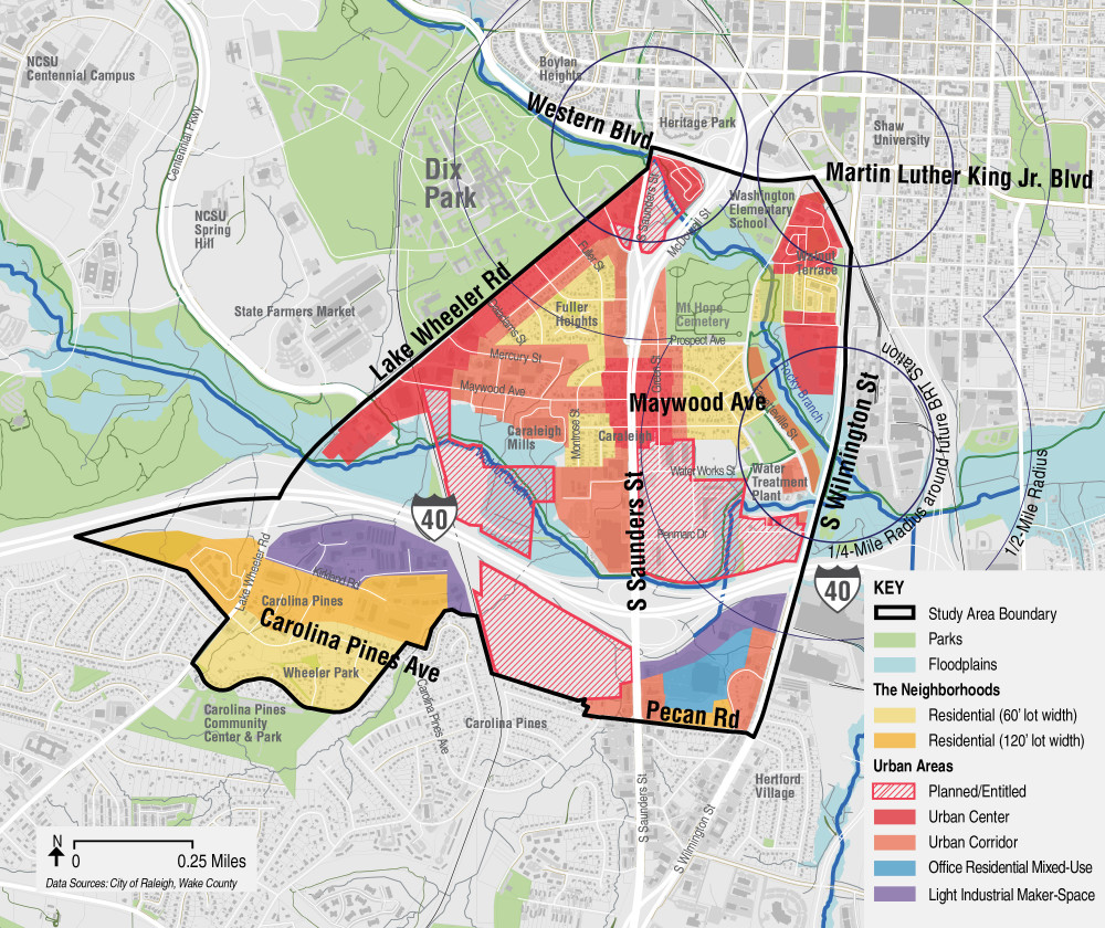
Note: While affordable housing can occur in any location, the number and type of units allowable may vary by the location.

Question title

1. In the past, Dix Edge communities preferred that future affordable housing address households with yearly incomes below 30% of the Area Median Income. To make this happen, the public money required to make affordable housing possible would exceed what is available. What response best reflects your view?
Note: The bigger the public subsidy required to make a unit affordable, the fewer number of units that can be created before the public subsidy runs out.

Increase the number of affordable housing units by serving the needs of households making no more than 60% of area median income. This will require smaller subsidies per unit and increase the number of affordable units constructed. This will also make the projects feasible for developers interested in creating affordable housing.
51%
Provide whatever public money is required to construct a limited number of affordable units for those at the lowest income levels.
29%
Don't use public money to subsidize affordable housing. Leave it up to nonprofit and market rate developers figure out how best to create more affordable housing on their own.
15%
Other
5%
Closed to responses | 267 Responses

Question title

2. Urban Center (Red Areas) – These areas cluster around major roadway intersections or are within ½ mile of the future BRT transit stations. The maximum number of stories in these areas might be 10 to 12 floors (or up to 20 stories if public benefits like affordable housing are provided). These could be areas that support a mix of uses, including residential. Which of the following best describes your support for this land use recommendation for the red areas?

Strong support
37%
Some support
31%
Not at all
18%
Neutral
14%
Closed to responses | 249 Responses

Question title

3. Urban Corridor (Orange Areas) – These areas are located along major roads and commercial areas in Dix Edge and buildings would not exceed 5 stories (or up to 12 stories if public benefits like affordable housing are provided) and contain mixed uses in some instances. Which of the following best describes your support for this land use recommendation in the orange areas?

Strong support
44%
Some support
30%
Not at all
13%
Neutral
13%
Closed to responses | 237 Responses

Question title

4. Residential (Yellow Areas) – These areas reflect traditional single-family neighborhoods. New housing development would include infill residential on vacant lots, redevelopment of declining housing units, and perhaps attached townhomes and small apartment buildings, but no commercial uses. Which of the following best describes your support for this land use recommendation in the yellow areas?

Strong support
54%
Some support
23%
Neutral
12%
Not at all
11%
Closed to responses | 235 Responses

Question title

5. In previous surveys, some expressed that access to broadband internet is too expensive. Are you aware of the Emergency Broadband Benefit provided by the FCC? This service provides financial assistance for eligible households.

No, I have not heard of the program.
75%
Yes, I am aware of this program.
25%
Closed to responses | 230 Responses