Town of Rush Pedestrian/Bicycle Safety & Connectivity Plan - Outreach #1
Town of Rush Pedestrian/Bicycle Safety & Connectivity Plan - Outreach #1
The first of the three public meetings was held to solicit input on existing and planned conditions and associated needs. The input from this initial public meeting will influence the development of potential alternatives. The second public meeting will be to present the draft recommended alternatives for community feedback. Comments received at this second public meeting will be considered by the PAC (Project Advisory Committee) when evaluating and selecting recommended strategies to be included in the draft Pedestrian Safety and Connectivity Plan. In addition, the final report will be presented to the Town Board, offering a third public opportunity for the community to be involved in the process.
Existing Conditions & Needs
Town of Rush Pedestrian/ Bicycle Safety & Connectivity Plan
Public Meeting #1
June 25, 2024, 6:00-8:00PM
William Udicious Pavilion, 1900 Rush Scottsville Rd, Rush, NY
Meeting Summary
On Tuesday, June 25th from 6:00-8:00PM, the Town of Rush held its first public meeting to educate the public about the Town of Rush Pedestrian/Bicycle Safety & Connectivity Plan. The goal of the plan is to improve the safety of trails and encourage more walking and biking throughout Rush. 26 people attended the meeting.
The meeting followed an open house format, allowing members of the public to drop in and provide feedback any time within the two-hour period. A reoccurring slide show presentation with project information was available for attendees to view. Four stations were set up around the room to provide information about the project and the opportunity to solicit input on existing and planned conditions.
The board stations included:
Project Overview
Provided the project background, objectives, and timeline
Existing Conditions
Displayed current pedestrian and bicycle infrastructure
Highlighted key destinations, traffic volumes, and speed data
Community Vision Station
Interactive boards for attendees to share their vision for
Safety and Connectivity Challenges/Opportunities
Displayed maps for attendees to pinpoint areas of challenges or opportunities for improvement
Feedback from this meeting will help shape the development of potential strategies and implementations options.
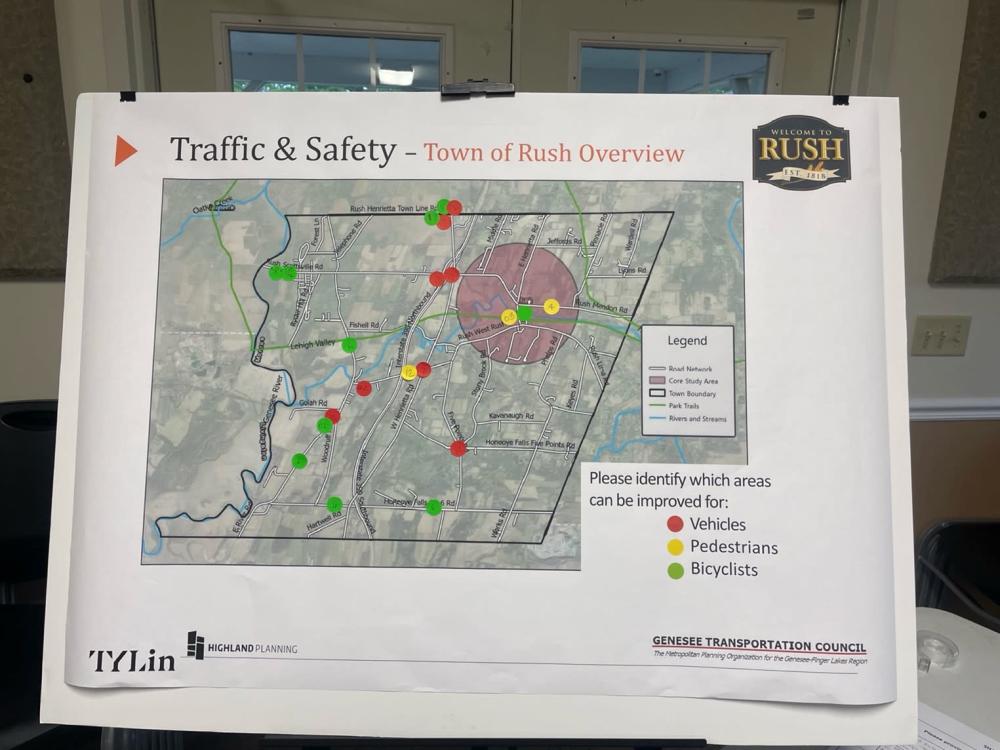
Town of Rush Traffic & Safety Overview
Here is the feedback based on the corresponding sticker number:
- Southbound signage around curve inadequate considering number of west side driveways some of which school buses stop at. Speed should be reduced, and visibility improved. Southbound vehicles put the pedal to the metal upon hitting the curve, doing 70s as they hit the stretch. Unsafe for bicycles and cars, existing drivers. County has not been responsive and not sure who to contact. (1 sticker)
- Speeding (in both directions on Rush-West Rush Rd) is excessive of the 30mph posted speed, 24/7, despite attempts at enforcement, and has been so for years. (1 sticker)
- Impossible to cross this street as a pedestrian and cyclist (3 stickers)
- Motorists travel absurdly way too fast on Rt 251. The speed limit is 35mph and I often times do not feel safe in my yard going to the mailbox, taking the trash out, gardening, walking, etc. (8 stickers)
- People die at this intersection. RHSD will not allow buses to cross at this intersection. Lots of bike traffic on Rush Henrietta Townline Road off West Henrietta Road
- Shoulders of the road are too small and pose a danger for bikers. Also a drop from the shoulder into a gravel area is dangerous. Cars and trucks go too fast and do no provide enough leeway for cyclists (3 stickers)
- Several intersections have a serious accident track record including deaths. Can a “dangerous intersection ahead” sign be posted ahead of those? (1 stickers)
- On Rt 251, between the Railroad museum and River road in Scottsville, there are now 4 public access sites on a half mile stretch of Road. (3 stickers)
- (Railroad museum, Hundred Acre Nature Park, Fishing Site, Genesee Valley Greenway). At the Railroad Museum it is 35 mph-the rest is 55 mph. There was an accident there this past weekend. Please reduce the entire road to 35 mph
- Rush Henrietta Town Line Road and West Henrietta Road are dangerous intersections. Rush Henrietta bus drivers have been told to not travel east to west on this road. Many accidents have occurred here. I have met with County officials and 2 chiefs of staff on this intersection and also have met with the DOT. Drivers headed north do not have sight of traffic headed east and wet until they are very close. They cannot see them until it is too late. (3 stickers)
- Rt 251 bicycle lanes needed headed toward Scottsville and back near and beyond the Genesee Valley Green Way (2 stickers)
- Near the park and ride there is no access road that heads to 390 North. The access road culminates to an ending facing South. The driver’s intention is to go North. The access road should be eliminated and converted to green space.
- West Rush Road headed west from West Henrietta is 55 mph. Why? There are residences and people walking. Please help use to change this to 35 mph and other calming strategies (1 sticker)
- Slow down the hamlet traffic. Add street trees. Add bike lanes. Extend the sidewalks to the North, West, and East
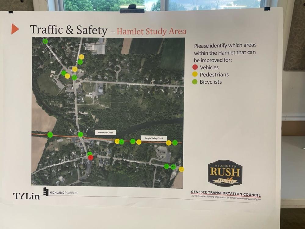
Hamlet Traffic & Safety Overview
Here is the feedback based on the corresponding sticker number:
- Unsafe crossing, low visibility, crosswalk, cars speeding (3 stickers)
- Bike pedestrian access to library and fields, bike racks, safe crossing
- Rush Lima Road speed limits are too high in the hamlet and leaving the hamlet all the way to Mendon. There are many more residences there then previously fatal accidents and other accidents have occurred and continue to occur. (3 stickers)
- Going out of the hamlet, heading north on East Henrietta Road between Chases and Leary school. The speed limits are too high. Leary school area is too high, then it goes 55 headed South then to 35 headed into the Hamlet. Can you help us make this better? A school area alone should be 30mph. Plus as you head south you go down a big hill which generally speeds up the auto. (2 stickers)
- Intersection is dangerous-cars go to fast. Signage is not well placed and clear
- Trail has standing water on side and on trial poor drainage (2 stickers)
- Wheel ruts inconsistent section-rough terrain
- Lehigh trail is often wet/muddy puddled in this area due to lack of drainage from south side to north side (and then to Honeoye Creek). Snow melts, ponding, etc, make this potentially useful trail useless at area “7” and a few others to the east (1 sticker)
Community Visioning Stations
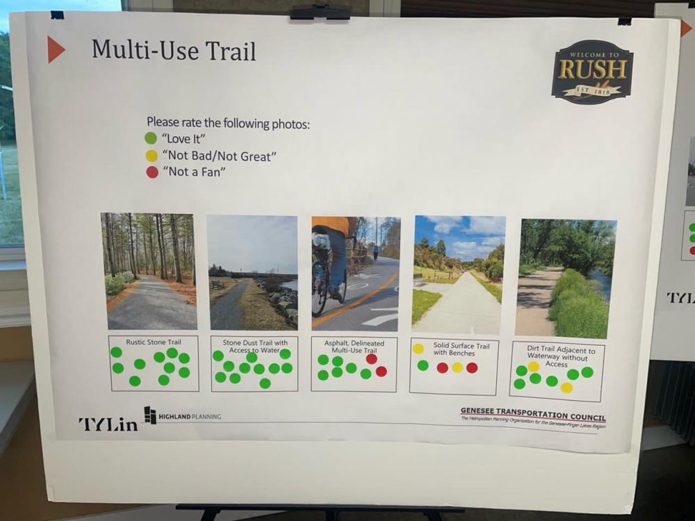
Multi-use Trail
Rustic Stone Trail:
Love It -10
Stone Dust Trail with Access to Water:
Love It - 11
Asphalt Delineated Multi-Use Trail:
Love It - 6
Not a Fan - 2
Solid Surface Trail with Benches
Love It - 1
Not Bad/Not Great - 2
Not a Fan - 2
Dirt Trail Adjacent to Waterway without Access
Love It Total - 6
Not Bad/Not Great - 2
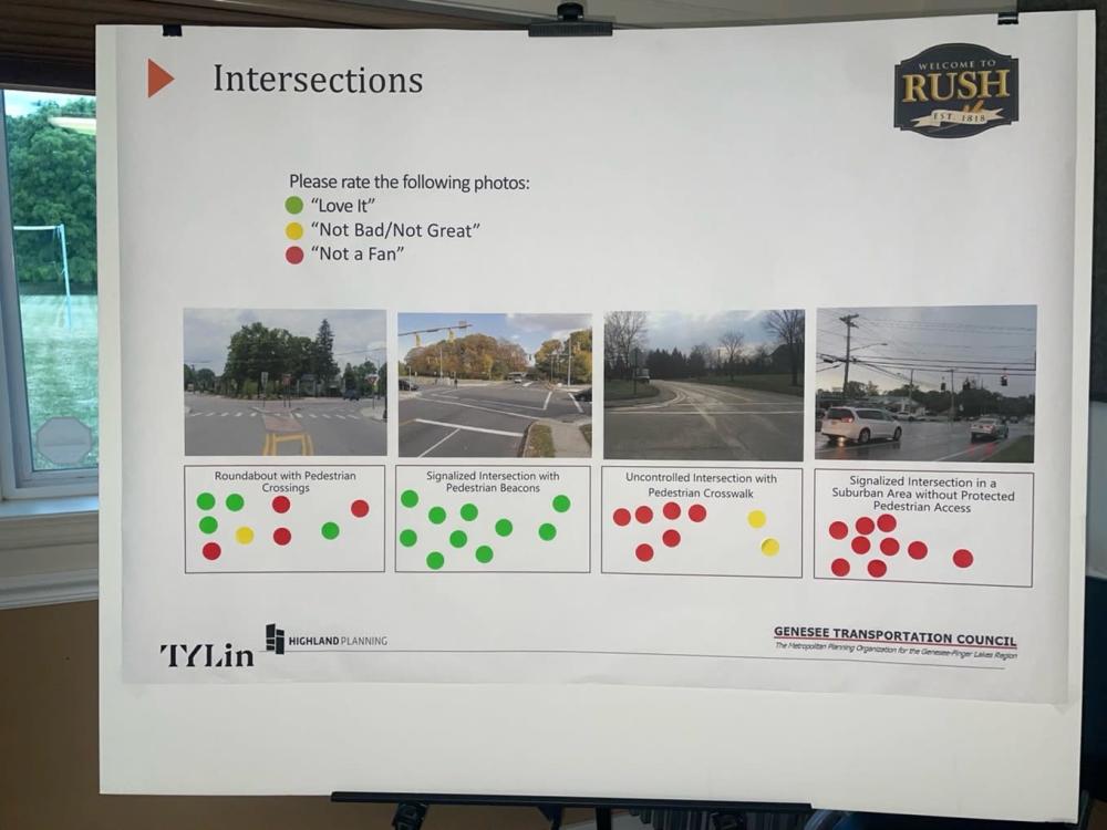
Intersections
Roundabout with Pedestrian Crossings
Love It- 4
Not Bad/Not Great - 1
Not a Fan - 4
Signalized Intersection with Pedestrian Beacons
Love It - 10
Uncontrolled Intersection with Pedestrian Crosswalk
Not bad/Not Great – 2
Not a Fan – 6
Signalized intersection in a Suburban Area without protected Pedestrian Access
Not a Fan - 6
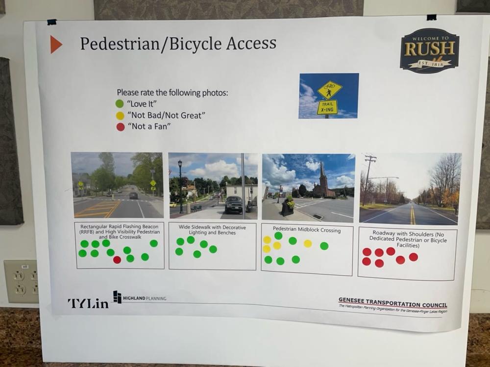
Pedestrian/Bicycle Access
Rectangular Rapid Flashing Beacon (RRFB) and High Visibility Pedestrian and Bike Crosswalk
Love It – 10
Not a Fan- 1
Wide sidewalk with Decorative Lighting and Benches
Love It – 6
Pedestrian Midblock Crossing
Love It – 6
Not bad/Not Great -4
Roadway with Shoulders (No dedicated Pedestrian or Bicycle Facilities)
Not a Fan – 7
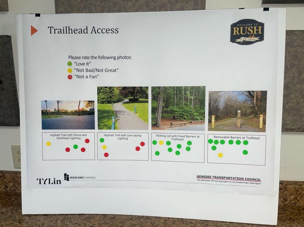
Trailhead Access
Asphalt Trail with Fence and Overhead Lighting
Love It - 1
Not Bad/Not Great - 1
Not a Fan – 3
Asphalt Trail with Low Laying Lighting
Love It - 1
Not Bad/Not Great - 1
Not a Fan – 3
Parking Lot with Fixed Barriers at Trailhead
Love It - 8
Not Bad/Not Great- 1
Removable Barriers at Trailhead
Love It- 8
Not Bad/Not Great - 1
Additional attendee comments:
Bike safety general. Town controlled roads
- When resurfacing projects come up, consider widening roads and added bike lanes
- Alleghany County- access to transportation
- Change of speed limits-it can be done based on Kathy Hochul Legislation
- Narrow Road-
- NYS signage available (Diamond)
- Triangle with bike signs
- Increase awareness of bikes/people
- Suggestion to have state troopers help to slow people down
- Drag racing on Sunday nights is a problem
- Idea to create a walking trail from Rush to Honeoye Falls
- 15A is dangerous for biking and walking, could use a bike lane at intersection of Route 6
- Increase safety of people/traffic
- Increase monitoring
- Suggestion for a trail and bike lane on Rush West Road near the church in Rush
- Concern about who shovels/maintains curbs and sidewalks especially with older generation
- Resident commented on blinking yellow light on Rush Henrietta Town Line Road and West Henrietta Road is an issue – there have been fatal crashes here and still considered a dangerous intersection. School district will not even allow buses to go through the intersection because they consider it too dangerous. Industrial site located next to intersection adds to issues as the trucks cause issues and slow downs when entering/exiting the site. Another resident also commented their same concerns for this intersection being dangerous.
- Resident noted they live on Rush Henrietta Town Line Road and it is a nice country road with lots of bikes.
- Resident noted on Route 251, there are different destinations (RR museum, 100 acres nature park, Genesee Valley Greenway) close together where the speed limit varies from 35-55 mph and it can make it difficult and feel unsafe with cars turning in and out of these areas. The speed limits should be looked at and lowered in this area.
- Resident noted Rush West Rush Road has high speeds and no shoulders.
- Resident noted where the park and ride is on Route 15 – when cars are crossing over to get to 390 it can feel dangerous crossing all those lanes of traffic and difficult to see.
- Resident noted East Henrietta Road – speed limit changes throughout but the school area speed limit doesn’t go down as low as it should.
