*closed* Gulf Branch Stream Resilience Project
*closed* Gulf Branch Stream Resilience Project
Gulf Branch is a high priority stream resilience project because of active erosion, infrastructure concerns and habitat degradation. Project goals include:
- Create a stable stream channel to accommodate storm flows, address active erosion and create overall resiliency to climate change
- Repair and protect vulnerable exposed infrastructure and prevent sewage releases to the stream and repeat emergency repairs
- Reduce excess sediment and nutrients to help protect Potomac River and Chesapeake Bay and meet regulatory requirements
- Enhance habitat and reduce impact to existing high-quality habitat
- Increase public safety and access to stream for recreational and biophilic purposes
The project is planned to go to construction in 2025. Learn more about the Gulf Branch stream resilience project.
Summer 2024 Feedback Form
Watch the virtual stream walk and the summer 2024 update videos below.
Virtual Stream Walk
Summer 2024 Update
Incorporating Feedback into the Design
We appreciate community input! Here is a summary of how we have incorporated feedback into the design.
| What we heard | How we addressed it |
| Prioritize stability in increased storm intensity and climate change | Primary goal is to create a stable stream channel. Special focus on areas with highest risk of inaction. |
| Limit disruption to area residents & park users | Split access for Reach 3 & nature center |
| Limit tree impacts Construction access through stream channel to limit impacts | Scope change, tree prioritization, careful review to limit impacts. |
| Lighter touch where possible: Address erosion before it becomes severe; use wood (natural capital) | Added more of Reach 2 to scope Incorporating wood structures throughout |
| Control more runoff upslope | Four Green Street rain gardens to be installed. Regenerative stormwater conveyance added to scope. Other stormwater facilities can be added over time. |
| Stream monitoring Use site-specific nutrient values | Benthic monitoring in stream project area. |
| Help areas downstream of Military Road | Green Street rain gardens, outfall repair projects, additional planting |
| Improve access to stream for nature center visitors and programming | Incorporate floodplain bench |
| Share reasoning and consider alternatives | Alternatives analysis considered seven approaches for each reach |
What's New in the Summer-Fall 2024 Update?
The following components are new in the summer-fall 2024 90% Gulf Branch design update. See below for details on each stream section.
- New regenerative stormwater conveyance added to capture, filter and slow down runoff.
- Trail closure plan to keep trail users safe through construction.
- Planting, maintenance and monitoring plan details.
- Updates to construction entrances based on community feedback
- Project construction start anticipated in 2025.
Regenerative Stormwater Conveyance
- A new regenerative stormwater conveyance will capture, filter and slow down runoff in six pool areas.
- Similar to width of current riprap channel.
- Natural feel, with stone, plants and amended soil.
- Will still allow trail users to cross the channel, similar to the current crossing.
- Four Green Street rain gardens will also help capture and absorb rain runoff in the watershed.
- Need to be realistic about how much water can be captured; stream project is still needed to address active erosion and infrastructure issues.
Phased Trail Closure Plan
The trail closures are broken into three phases.
- During the work in Reaches 1 & 2, the trails near the Nature Center and Reach 3 would be open.
- Trails leading up to the work areas will be open for exercise, but will not provide through traffic.
- The pedestrian bridge behind the Glebe Park tennis courts will be open after hours and on weekends.
- During the work near Broyhill Park, the trails near the Nature Center and Reaches 1 & 2 would be open.
- During the work downstream of Military Road, the trail near the pump house would be closed.
- The Nature Center driveway and parking lot would remain open.
- Once the construction contractor is selected, more details will be available in a pre-construction meeting.
See the trail closure exhibits for more details (9MB PDF).
Planting, Maintenance and Monitoring
Replanting
- 286 overstory trees, 293 understory trees, 350 shrubs
- 4,110 shrub tubelings, 404 live stakes, 220 plugs, extensive seeding
- More than 150% of planting requirements
Planting for Success:
- Robust, dense planting plan tailored to conditions at Gulf Branch: Right plant, right place
- Larger tree sizes (¾ - 1 inch)
- Choosing plants that have climate suitability, disease resistance
Ensuring Survivability
- Establishment watering, deer shelters/fencing
- Plant replacement, supplemental planting
- Ongoing invasive plant management
- Monitoring for success: Setting targets for % invasive plants, tree canopy, woody stems per acre
Stream Structure Stability and Monitoring
- Engineering inspection and photo documentation of stream structures
- After significant storm events, stream structures and vegetation will be evaluated carefully.
- Ongoing commitment to the success of the stream resiliency project.
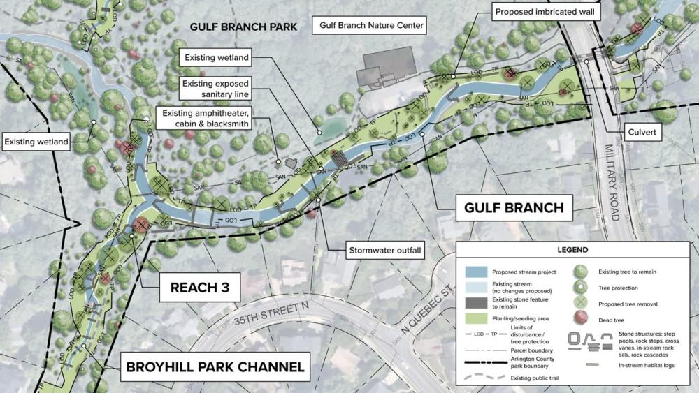
Gulf Branch Main Stem near the Nature Center
From downstream to upstream (right to left), key components of the design in this area include:
- Step pools downstream of Military Road to slow down water coming from the culvert.
- Stacked stone wall to protect driveway to Gulf Branch Nature Center.
- Gently sloped floodplain bench near nature center. This will allow better access to the stream for park programs and provide a connected floodplain to better accommodate storm flows.
- Raise the stream bed to cover the exposed sanitary sewer pipes near the cabin.
- Protect the new stream channel with stone and log structures to prevent future erosion.
- Existing bedrock incorporated into design.
- Replanting along stream corridor.
Use this design map for the next two questions.
Gulf Branch near Broyhill Park (Reach 3)
Key components of the design in this area include:
- Raise the stream bed to bury the exposed sanitary sewer pipes.
- Protect the new stream channel with sturdy stone structures to prevent future erosion.
- In the gully next to the stairs from Broyhill Park: Add stone step pools to protect the channel and handle storm flows through the park.
- Replanting along stream corridor.
- See map design view above for additional detail.
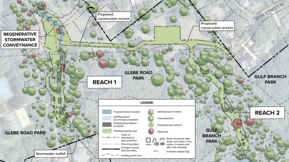
Reach 2: Small Dry Channel with Increased Erosion
Key components of the design in this area include:
- Stabilize the dry stream bed with logs and stone structures.
- Minimal regrading and limited impacts. Can be constructed using smaller equipment.
- Robust replanting to complement the stream structures.
Use this design map for the next two questions.
Reach 1: Eroding Channel behind Glebe Park Tennis Courts
Key components of the design in this area include:
- Regenerative stormwater conveyance added as a best management practice (BMP). Includes six step pools that can capture and filter stormwater.
- In severely eroded areas, raise the stream bed and resize the channel to accommodate storm flows.
- Protect the new stream channel with stone and log structures to prevent future erosion.
- Replanting along stream corridor.
- See the map design view above for more detail.