West Street Multi-Use Path - Phase 3 of DT North-South Greenway Connector
West Street Multi-Use Path - Phase 3 of DT North-South Greenway Connector
Phase 3 of the North-South Downtown Greenway Connector will provide safe active transportation access on N. West Street between Peace St. and Wade Ave. This phase of the project will connect downtown Raleigh to Five Points, and is being proposed as a pilot project with continued stakeholder engagement 3 months, 6 months, and 12 months after installation.
Three alternative design concepts are being considered for this project between Peace Street and Dortch Street. An in-street multi-use path is being considered between Dortch Street and Wade Avenue, which will connect into two key points: the entrance of the future Smoky Hollow Park and the existing Wade Avenue underpass/multi-use path into Five Points.
A snapshot of each design alternative is below. In order to view design options for the full corridor, please see the following PDF:
Please review the summaries below outlining different design options and take our survey at the bottom of this page to provide feedback. The survey will remain open through January 5, 2024. We want to hear from you!
Alternative 1: (click photo to enlarge)
- Continuous 11 ft. multi-use path
- East side of West Street
- Dedicated space for active transportation users
- Parking protected
- 11 ft total buffer between vehicle travel lane and pedestrians
- 3 ft buffer between parked vehicles and multiuse path
- Narrows vehicle travel lanes
- Induces slower speeds
- Parking Impact Estimate
- Peace Street - Cleveland Street
- 44 existing spaces today
- Alt. 1 retains 31 spaces
- Cleveland Street - Dortch Street
- 78 spaces existing today
- Alt. 1 retains 46 spaces
- Peace Street - Cleveland Street
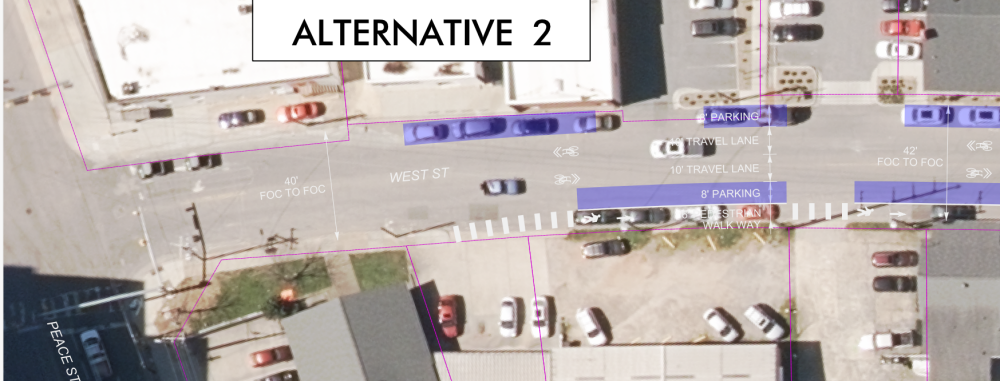
Alternative 2: (click photo to enlarge)
- 6 ft. pedestrian walkway between Peace - 900 N. West St.
- East side of West Street
- Dedicated space for pedestrians
- Bikes and cars in shared vehicle travel lane
- 11 ft multiuse path between 900 N. West - Wade
- Parking protected
- Creates 8 ft buffer between vehicle travel lane and pedestrians
- No buffer between parked vehicles and walkway
- Narrows vehicle travel lanes
- Induces slower speeds
- Parking Impact Estimate
- Peace Street - Cleveland Street
- 44 existing spaces today
- Alt. 2 retains 44 spaces
- Cleveland Street - Dortch Street
- 78 spaces existing today
- Alt. 2 retains 36 spaces
- Peace Street - Cleveland Street
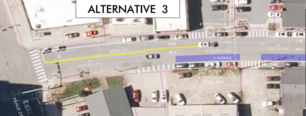
Alternative 3: (click photo to enlarge)
- 6 ft. pedestrian walkway between Peace – Cleveland St.
- East and west side of West St.
- Dedicated space for pedestrians
- Bikes and cars in shared vehicle travel lane
- Parking protected
- 9 ft total buffer between vehicle travel lane and pedestrians
- 1 ft. buffer between parked vehicles and walkway
- 11 ft multiuse path between Cleveland St. - Wade
- Parking Protected
- 11 ft total buffer between vehicle travel lane and pedestrians
- 3 ft buffer between parked vehicles and multiuse path
- Parking Protected
- Narrows vehicle travel lanes
- Induces slower speeds
- Parking Impact Estimate
- Peace Street - Cleveland Street
- 44 existing spaces today
- Alt. 3 retains 34 spaces
- Cleveland Street - Dortch Street
- 78 spaces existing today
- Alt. 3 retains 36 spaces
- Peace Street - Cleveland Street
Between Dortch Street and Wade Avenue:
- All three alternatives propose an 11 ft in-street multi-use path between Dortch Street and Wade Avenue
- Continuous 11 ft. multi-use path
- East side of West Street
- Dedicated space for active transportation users
- Parking protected
- 11 ft total buffer between vehicle travel lane and pedestrians
- 3 ft buffer between parked vehicles and multiuse path
- Narrows vehicle travel lanes
- Induces slower speeds
- Parking Impact Estimate
- 51 spaces existing today
- 28 spaces retained with proposed design
- Continuous 11 ft. multi-use path
If you have any questions or need more information, please contact barbara.godwin@raleighnc.gov.


