Question title

How frequently do you use the City of Raleigh's greenway system?

a. Daily
b. A few times a week
c. A few times a month
d. A few times a year
e. Never
Closed to responses

Question title

Why do you currently use greenways trails in the City of Raleigh? Select all that apply.

a. For exercise
b. For recreation
c. To commute (walk, bike, etc.) to work and/or school
d. To run errands or go to appointments
e. To make connections between other types of transit (bus, taxi, etc.)
f. Other
g. I do not use greenways
Closed to responses

Question title

How would you use the proposed Big Branch Greenway once it is constructed? Select all that apply.

a. For exercise
b. For recreation
c. To commute (walk, bike, etc.) to work and/or school
d. To run errands or go to appointments
e. To make connections between other types of transit (bus, taxi, etc.)
f. I do not use greenways trails
g. Other
Closed to responses

Question title

How often do you believe you will use the Big Branch Greenway Connector when it's complete?

a. Daily
b. A few times per week
c. A few times per month
d. A few times per year
e. Never
f. I live too far away to use it.
Closed to responses

Question title

Which trail amenities would you like to see along the Big Branch Greenway Connector? Select all that apply.

c. Trash receptacles
d. Recycling / composting receptacles
e. Public art
f. Seating
g. Wildflower and pollinator plantings
h. Water fountains
i. Dog waste stations
j. Fitness equipment
k. Other
Closed to responses

Question title

What factors discourage you from using the City of Raleigh's greenway system? Select all that apply.

a. I do not feel safe crossing the streets / intersections between segments of greenways due to motor vehicle traffic / speed
b. Personal safety concerns while on the greenway
c. Conditions of existing trails
d. Lack of signage
e. Lack of parking
f. Lack of nearby destinations
g. Not conveniently located / not enough greenways
h. Hours of operation of trails is inconvenient" (currently dawn to dusk)
i. Lack of interest
j. Other
Closed to responses

Question title

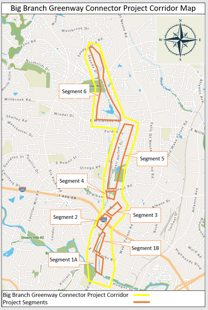
All alignment options for Segment 1A start at the Crabtree Creek Trail and end at Six Forks Road. Review the potential alignments for Section 1A of the Big Branch Greenway below by clicking on the map image and reading the descriptions for each alternative. Note the advantages and challenges for each alternative noted on the right side of the image. Then choose the alignment option you prefer most.

All alignment options for Segment 1A start at the Crabtree Creek Trail and end at Six Forks Road. Review the potential alignments for Section 1A of the Big Branch Greenway below by clicking on the map image and reading the descriptions for each alternative. Note the advantages and challenges for each alternative noted on the right side of the image. Then choose the alignment option you prefer most.
Alternative A (Black) - East of Big Branch > Shelby Dr > Six Forks Road
Alternative B (Purple) - East of Big Branch > Calibre Chase Dr > Six Forks Rd
Alternative C (Red) - West of Big Branch > Cross Big Branch to Shelby Dr > Six Forks Rd
Alternative D (Pink) West of Big Branch > Cross Big Branch to Calibre Chase Dr > Six Forks Rd
Closed to responses

Question title

All alignment options for Segment 1B start at Six Forks Road and end at Wake Towne Drive. Review the potential alignments for Section 1B by clicking on the map image and note each alignment options advantages and challenges listed on the right side of the image. Then select the alternative alignment option you prefer most.

All alignment options for Segment 1B start at Six Forks Road and end at Wake Towne Drive. Review the potential alignments for Section 1B by clicking on the map image and note each alignment options advantages and challenges listed on the right side of the image. Then select the alternative alignment option you prefer most.
Alternative A (Black) - West of Big Branch, Parallel to Anderson Dr > Cross Big Branch after .25 Miles > Continue to Wake Towne Dr
Alternative B (Green) - East of Big Branch, Parallel to Anderson Dr > Cross Big Branch after .1 Miles > Continue for .15 miles > Cross Big Branch again before Continuing to Wake Towne Dr
Alternative C (Yellow) - Plantation Dr > Belvin Rd > Continue to Wake Town Rd
Alternative D (Orange) - West of Big Branch, Parallel to Anderson Dr > Cross Big Branch after .2 Miles > Continue to Wake Towne Dr
Closed to responses

Question title

All alignment options for Segment 4 start at St Albans Drive and connect to Hardimont Road at Quail Hollow Drive. Review the alignment options for Segment 4 by clicking on the map image. Note each alignment options advantages and challenges noted on the right side of the image. Then select the alignment alternative you prefer most.

All alignment options for Segment 4 start at St Albans Drive and connect to Hardimont Road at Quail Hollow Drive. Review the alignment options for Segment 4 by clicking on the map image. Note each alignment options advantages and challenges noted on the right side of the image. Then select the alignment alternative you prefer most.
Alternative A (Black) - Quail Hollow Dr > St Albans Dr >Continue west of Quail Hollow Rd > Hardimont Rd
Alternative B (Green) - Quail Hollow Dr > St Albans Dr > Continue east of Quail Hollow Rd > Hardimont Rd
Alternative C (Red) - Quail Hollow Dr > St Albans Dr > Continue to Quail Hollow Rd > Hardimont Rd
Closed to responses

Question title

All alignment options for Segment 6 begin on Millbrook Road, near Quail Hollow Drive, and end at Sandy Forks Road. Review the potential alignments for Segment 6 by clicking on the map image. Note each alignments advantages and challenges on the right side of the image. Then select the alignment option you prefer most.

All alignment options for Segment 6 begin on Millbrook Road near Quail Hollow Drive and end at Sandy Forks Road. Review the potential alignments for Segment 6 by clicking on the map image. Note each alignments advantages and challenges on the right side of the image. Then select the alignment option you prefer most.
Alternative A (Black) - Millbrook Rd > West of Big Branch > North along pond > Through trees to Spring Forest Rd > Sandy Forks Rd
Alternative B (Orange) - West through residential streets > North at Latimer Rd / Sweetbriar Dr > Through trees to Spring Forest Rd > Sandy Forks Rd
Alternative C (Red) - Millbrook Rd > North through residential streets > Springfield Dr > West to Mapleridge Rd > Through trees to Spring Forest Rd > Sandy Forks Rd
Alternative D (Yellow) - Millbrook Rd > East of Big Branch > North along pond > Through trees to Spring Forest Rd > Sandy Forks Rd
Alternative E (Pink) - Millbrook Rd > West along Pond > North at Cederwood Dr > Through trees to Spring Forest Rd > Sandy Forks Rd
Closed to responses

Question title

Mark areas (streets, intersections, neighborhoods, etc.) that need the most pedestrian and bicycle infrastructure improvements along the proposed Big Branch Greenway corridor in order to improve access to the greenway. Drag and drop pins/lines for bicycle and/or pedestrian infrastructure at desired locations.

Hint: Zoom in to place more accurate pin/line locations. You can drag and place the person icon on the left of the map screen to see a street view.

Question title

What is your home zip code?

Closed to responses

Question title

What is your age?

Under age 18
Age 18-24
Age 25-34
Age 35-44
Age 45-54
Age 55 and older
Prefer not to answer
Closed to responses

Question title

What is your gender?

a. Female
b. Male
c. Transgender
d. Do not identify as male, female or transgender
e. Other
f. Prefer not to answer
Closed to responses

Question title

What is your race/ethnicity?

a. Native American or American Indian
b. Asian
c. Black or African American
d. Hispanic, Latino or Spanish Origin
e. Native Hawaiian or Other Pacific Islander
f. White
g. Other
h. Prefer not to answer
Closed to responses

Question title

Do you or does someone in your household have a disability or long-term health condition?

a. Yes
b. No
c. Prefer not to answer
Closed to responses