 U-5791: Jacksonville Parkway Extension
U-5791: Jacksonville Parkway Extension
Preliminary Engineering Activities for this project
have resumed.
 Responses to comments and questions received during the public comment period have been posted to the webpage and can be viewed here.
The N.C. Department of Transportation is proposing to extend Jacksonville Parkway (S.R. 2714) from N.C. 53 (Western Boulevard) to U.S. 17 (New Bern Highway), a distance of approximately 4 miles. The corridor is a mixture of residential and commercial uses and serves as a commuter route to and from Camp Lejeune. The Jacksonville Parkway extension will serve as an important connector to Western Boulevard and U.S. 17, improving overall mobility in the area.
Study Area and Detailed Study Alternatives
DISCLAIMER: This information is intended for general reference only.
NCDOT is not responsible for its accuracy or use.
To turn on or off individual corridors for viewing, please click on the icon at the top left of the map and then click on the individual corridors you wish to turn off/on.
Study corridors are typically 500 ft wide although typical roadway Right of Way for this project is expected to be 160 ft or less.
The corridor alternatives represent potential impact areas for the proposed roadway improvements.
Alternative Corridors are preliminary and subject to change.
PROJECT DESCRIPTION
The N.C. Department of Transportation is proposing to extend Jacksonville Parkway (S.R. 2714) from N.C. 53 (Western Boulevard) to U.S. 17 (New Bern Highway), a distance of approximately 4 miles. The corridor is a mixture of residential and commercial uses and serves as a commuter route to and from Camp Lejeune. The Jacksonville Parkway extension will serve as an important connector to Western Boulevard and U.S. 17, improving overall mobility in the area.
The proposed project is located in northeast Jacksonville, which is located in Onslow County. The City of Jacksonville is the 14th largest city in North Carolina and is home to the largest Marine Corps base on the east coast, Camp Lejeune, and also to the Marine Corps air station New River. The project study area is located partially within the City of Jacksonville’s limits and partially within unincorporated Onslow County.
The Department of Defense is one of the largest employers for the county, employing over 91,000 people. It is projected for the number of jobs to increase to 150,000 in Onslow County by 2045. Camp Lejeune is located approximately 5.5 miles southeast of the proposed project, and the Marine Corps Air Station is located approximately 4.5 miles southwest of the project.
Onslow County has an economy that is focused mainly on tourism and commercial activity geared toward Camp Lejeune. U.S. 17 and U.S. 258 are used as primary tourist commuter routes to coastal communities. The proposed project is located approximately 2.5 miles northeast of the New River and downtown Jacksonville. Jacksonville Commons and Richard Ray Park are two prominent recreational resources located within the project vicinity, which increases the demand for bicycle, pedestrian, and transit facilities in the area.
According to Jacksonville Urban Area Metropolitan Planning Organization’s (JUMPO) 2045 MTP, long-term goals for the area include congestion reduction, economic vitality, environmental sustainability, multimodal integration, safety and security, and system preservation.
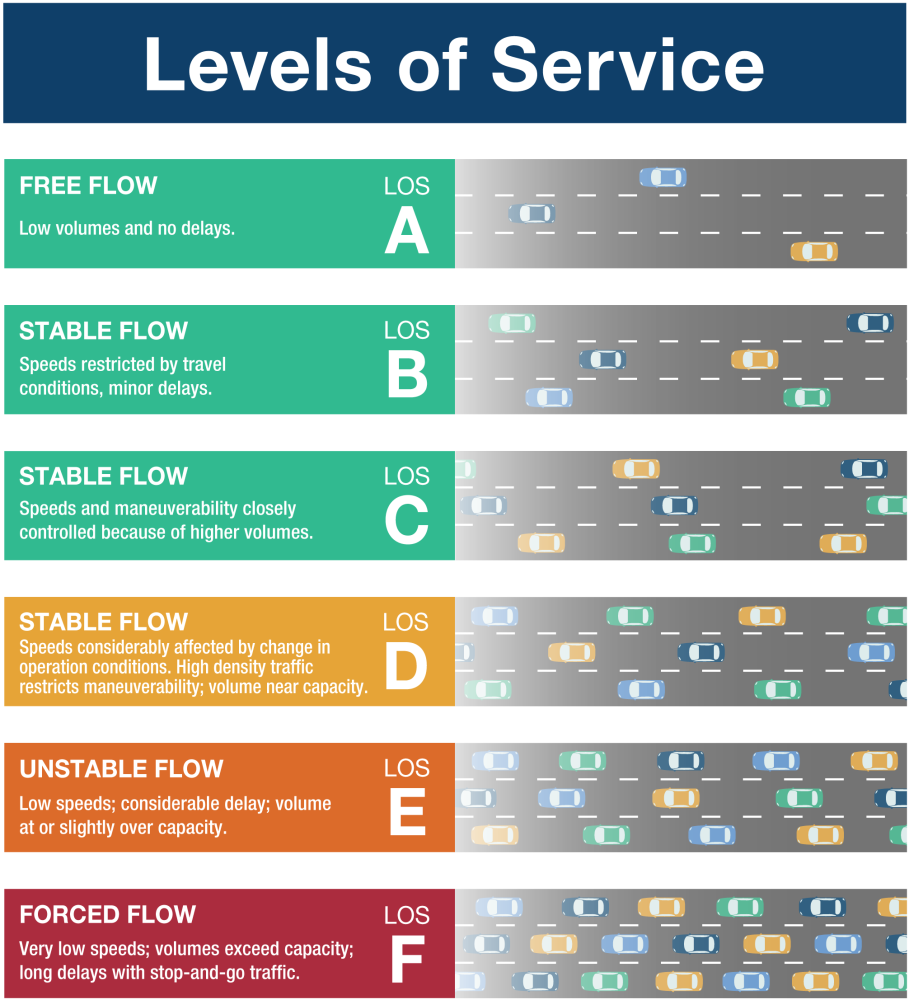
TRAFFIC AND LEVEL OF SERVICE
There are several intersections along the Western Boulevard corridor that currently operate under congested conditions and “fair” to “poor” Level of Service (LOS)* at peak hours (AM or PM). LOS D (approaching unstable flow) is considered “fair” conditions. LOS E (unstable flow) and LOS F (breakdown in flow) are considered “poor” conditions. While traffic operations along Ramsey Road do not indicate congested conditions at this time, increases in traffic are expected to worsen traffic conditions along the roadway in the future and decrease LOS along the roadway.
- Traffic levels along Ramsey Road are expected to increase 100-225% over the next 20 years
- Traffic along Western Boulevard is expected to increase 24-57% in the next 20 years
- Traffic along U.S 17 is expected to increase 37-69% during this same time period
There are limited options for transportation access in this area of Jacksonville.
*The relationship of travel demand compared to the roadway capacity determines the level of service (LOS) of a roadway. Six levels of service identify the range of possible conditions. Designations range from LOS A, which represents the best operating conditions, to LOS F, which represents the worst operating conditions.
PURPOSE OF THE PROJECT
The Jacksonville Urban Area MPO’s (JUMPO) 2045 Metropolitan Transportation Plan (MTP) states that the Jacksonville Parkway Extension Project is an important connection needed to enhance mobility, improve accessibility, and provide an alternative connection to U.S. 17.
The primary purposes of the proposed project are to:
- Provide an alternate route to alleviate existing and future congestion along existing roadways
The project will help alleviate congestion along existing roadways by distributing vehicles to the alternative route, as well as by increasing roadway capacity along Ramsey Road.
- Provide an alternative route to enhance mobility along Western Boulevard and U.S. 17
The new location roadway will provide an alternative route for drivers to avoid congestion along existing roadways.
CORRIDOR ALTERNATIVE SCREENING
The project team developed a screening process for the development and evaluation of alternatives. The first screening determined which general concepts should be eliminated from further consideration based on whether they meet the purpose and need. In addition to the No-Build Alternative, five general approaches were considered, including system strategies (Travel Demand Management [TDM] and Transportation System Management [TSM}), mass transit, new location alternatives, and improvements to the existing roadway.
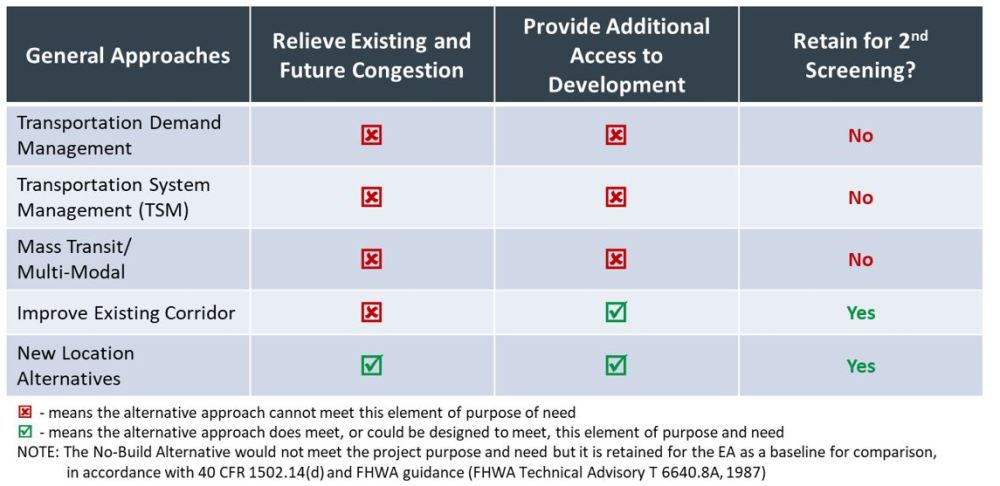
First Screening Results – General Approaches
The second screening of the corridor alternatives evaluates the ability of each of the five potential corridors to meet the project’s purpose and need based on the established screening criteria as well as design considerations, traffic operations, and impacts to the human and natural environments. The screening compares corridor concepts and eliminates those that are unreasonable, impractical, and/or have higher impacts or less improvement to traffic flow.
CORRIDOR ALTERNATIVES CARRIED FORWARD FOR FURTHER CONSIDERATION - June 2021
Alternative 1A – New Northwestern Alignment and Ramsey Widening
Alternative 1B – New Northwestern Alignment and Ramsey Widening
Alternative 2A – New Southeastern Alignment and Ramsey Widening
Alternative 2B – New Southeastern Alignment
Alternative 3 – Improve Existing Western Boulevard and New Bern Highway
CORRIDOR ALTERNATIVES CARRIED FORWARD FOR FURTHER CONSIDERATION - October 2021
Alternative 1B – New Northwestern Alignment and Ramsey Widening
Alternative 2B – New Southeastern Alignment
CORRIDOR ALTERNATIVES UPDATE - April 2023
After receiving input from the public, state and federal agency partners and local stakeholders, an additional alternative was added. The following alternatives have been carried forward for detailed study:
No Build Alternative
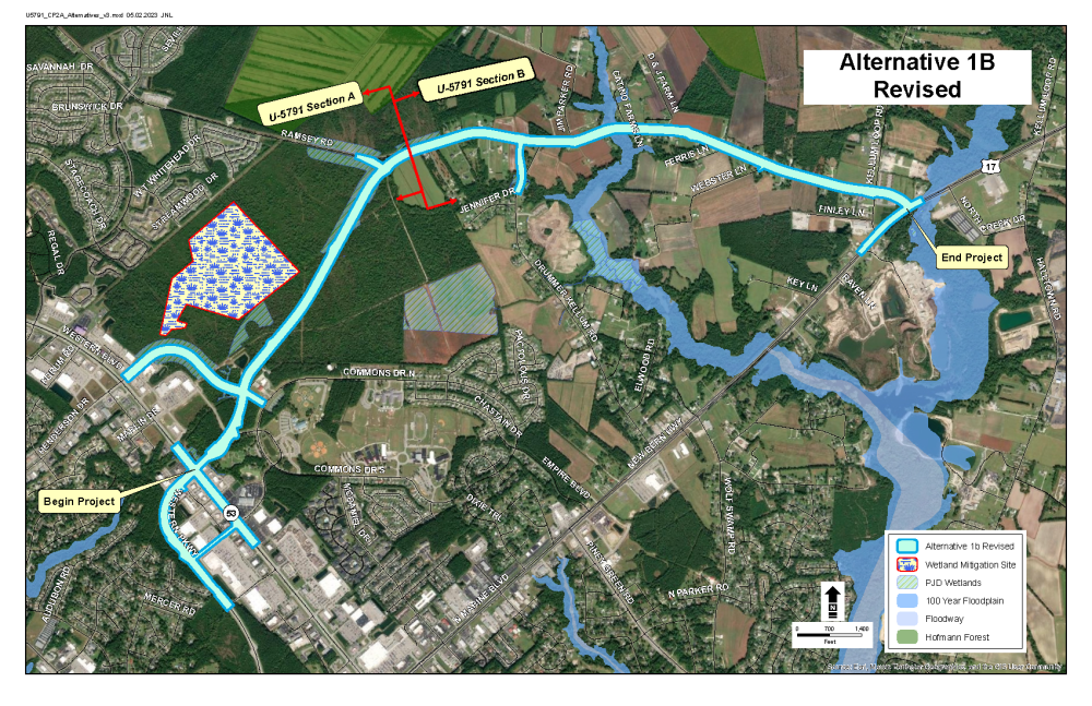
1B Revised
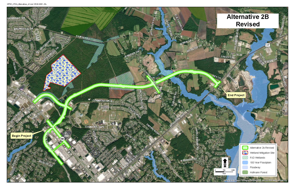
2B Revised
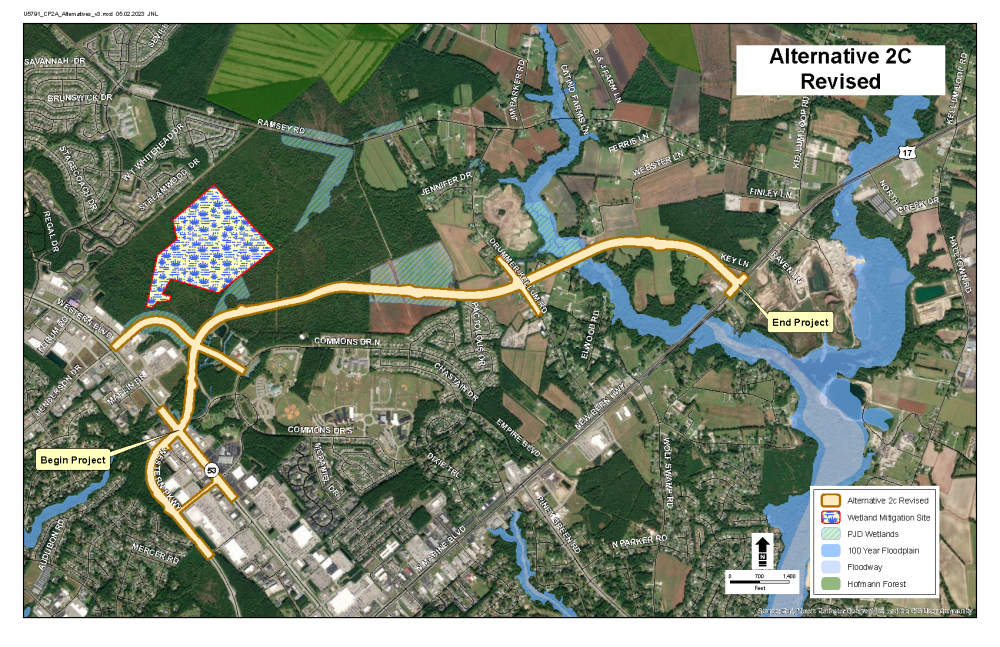
2C Revised
MAPS
Maps of detailed study alternatives
(These maps will open in a new browser window where you can view or download them)
Alternative 1B-REVISED (Blue)
Alternative 2B-REVISED (Green)
Alternative 2C-REVISED (Tan)
NEXT STEPS
Preliminary designs for the alternatives will be advanced and evaluated in the State Environmental Assessment (EA)/ Finding of No Significant Impacts (FONSI)
The Draft SEA/FONSI is expected to be completed in Spring of 2024, followed by a design public meeting. A Preferred Alternative will be identified for the project and presented in a final environmental document.
NCDOT accepts comments throughout all planning, design and construction phases of project development.
All comments will be taken into consideration, and carry equal weight, regardless of submittal method.
You may leave a comment or question below
Or
Email the comment or question to Jacksonville-Parkway-Extension@PublicInput.com
Or
Phone Number: (855) 925-2801 Code: 2342
Comments should be submitted by _____________________.
HISTORY OF THE PROJECT
2007
NCDOT completed a Feasibility Study that identified the need for a new connector between Western Boulevard and U.S. 17
2015
Jacksonville Urban Area MPO 2040 Long Range Transportation Plan recommended the Jacksonville Parkway Extension
2017
NCDOT Highway Division 3 began project development, environmental and engineering studies for the project (October 2017)
2018
A project newsletter was sent to surrounding residents, elected officials and other local officials in October of 2018. The newsletter introduced the project and provided an overview of the need for the project and overall development process.
2021
A virtual public meeting was held in June of 2021 to solicit feedback from the public regarding the corridor alternatives. This input was used to help inform the preliminary alternatives.
2022
Multiple variations of the alternatives were developed to avoid and minimize impacts to proposed development.
2023
Alternatives were selected to move forward for detailed study in the environmental document.
ESTIMATED COSTS
Activity | Estimated Cost* |
Right of Way Acquisition and Utility Relocation | $ 14.6 million |
Construction Costs | $ 61.3 million |
Total Cost | $ 75.9 million |
* Estimated Costs as shown in Current 2018-2027 STIP and are subject to change
U-5791A:
Right of Way Acquisition $8.7 M
Construction $42.3 M
U-5791B:*
Right of Way Acquisition $10.2 M
Construction $22.6M
*U-5791B is currently unfunded for ROW and Construction
TIMELINE
Milestone | Date* |
Design Public Meeting | Spring 2024 |
Environmental Document (State EA/FONSI) | Winter 2024 |
Right of Way Acquisition (U-5821A nOnly) | Summer 2026 |
Construction (U-5791A Only) | Summer 2026 |
* Future dates are preliminary and subject to change.
U-5791A is funded for ROW and Construction.
U-5791B is not currently funded for ROW or Construction.
PUBLIC INVOLVEMENT
NCDOT will provide auxiliary aids and services under the Americans with Disabilities Act for disabled individuals who want to participate in any meetings. If you need assistance under ADA, please either email (Jacksonville-Pkwy@publicinput.com) or call (984-205-6615 and enter code 2342).
Persons who do not speak English, or have a limited ability to read, speak or understand English, may receive interpretive services upon request prior to any meeting by calling 1-800-481-6494.
Aquellas personas que no hablan inglés, o tienen limitaciones para leer, hablar o entender inglés, podrían recibir servicios de interpretación si los solicitan antes de la reunión llamando al 1-800-481-6494.
PROJECT CONTACT INFORMATION
David Leonard
NCDOT Project Manager
NCDOT Division 3
5501 Barbados Blvd
Castle Hayne, NC
__________________________
Robert Boot
Consultant Project Manager
Atkins
1616 E. Millbrook Rd. Suite 160
Raleigh, NC 27609
jacksonvilleparkway@publicinput.com
RESOURCES FOR PROPERTY OWNERS
Although the N.C. Department of Transportation works to minimize the number of homes and businesses displaced by a road project, it is inevitable, in many cases, that a certain amount of private property is needed. The following information explains right of way acquisition and answers questions about the process.
Right-of-Way Brochure Single Page Layout Folleto del Proceso de Adquisición de Bienes Raíces
Right-of-Way Frequently Asked Questions
Right of way Acquisition Process Videos