 R-5727 - Bridges Street Extension
R-5727 - Bridges Street Extension
This site is intended to cather comments and feedback on this project
for additional information on this project, please visit : https://www.ncdot.gov/projects/bridges-street-improvements/Pages/default.aspx
Planning and development are underway to widen and construct a new roadway from Bridges Street to northwest of McCabe Road in Carteret County. The proposed project would improve the road to a four-lane, median divided roadway with curbs, wide outside lanes, and sidewalks pending municipal approval.
The project is anticipated to relieve congestion on U.S. 70 and improve mobility throughout the area. Additionally, the project would provide better access to the Business Park on Business Drive.
The project is expected to:
Reduce congestion along U.S. 70
Provide better mobility in the area
Provide direct access to the Business Park
Improve the existing roadway to a multi-lane, median-divided facility
Project Study Area Map:
Current Map
Map of NCDOT Recommended Alternative
Clicking on the link above or the picture below will open the pdf map in a new window for viewing or downloading.
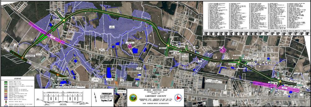
Proposed Improvements
- The entire project will be a 4-lane, median divided roadway consisting of
- 2 lanes in each direction
- a 17 and a half foot median
- Curb and Gutter
- 5-foot sidewalks have been proposed subject to a municipal agreement
- Beginning west of Sam Garner Road to the railroad a new roadway will be constructed
- The Sam Garner rail crossing will be closed and cul-de-sac'd on both sides of the railroad right of way
- A new bridge will be constructed over the railroad
- The new location roadway will continue from the railroad across Sam Garner Road.
Are there questions or comments you would like to provide on the NCDOT Recommended Alternative?
PROJECT COST
Milestone | Estimated Amount* |
Property Acquisition | $ 19.9 Million |
Construction Costs | $ 131.5 Million |
Total Cost | $ 151.4 Million |
* Estimated Costs as shown in Current STIP and are subject to change
PROJECT COST AND TIMELINE
Milestone | Date* |
Environmental Document Complete | January 2026 |
Right of Way Acquisition Begins | May 2024 |
Construction Begins | May 2029 |
* Future Dates are subject to change
PROJECT CONTACT INFORMATION
Jake Green, PE |
NCDOT Project Engineer |
NCDOT Division 2 |
1037 W.H. Smith Blvd. |
Greenville, NC 27835 bridgesst@publicinput.com (984) 205-6615 Enter Code 1983 to leave a message |
PROJECT CONTACT INFORMATION
Candice Andre, AICP |
Consultant Project Manager |
VHB |
940 Main Campus Drive Suite 500 |
Raleigh, NC 27606 bridgesst@publicinput.com (984) 205-6615 Enter Code 1983 to leave a message |
Title VI Feedback
To ensure we’re hearing from a broad set of voices, would you be willing to share (completely anonymously) some information about yourself?
If so, please click here: https://publicinput.com/ncdot-title-vi-form
RESOURCES FOR PROPERTY OWNERS
Although the N.C. Department of Transportation works to minimize the number of homes and businesses displaced by a road project, it is inevitable, in many cases, that a certain amount of private property is needed. The following information explains right of way acquisition and answers questions about the process.
Right-of-Way Brochure Single Page Layout Folleto del Proceso de Adquisición de Bienes Raíces
Right-of-Way Frequently Asked Questions
Right of way Acquisition Process Videos
Page last updated: June 3, 2026
ADA Compliance Checked