 R-5709: N.C. 211 - Aberdeen to Raeford
R-5709: N.C. 211 - Aberdeen to Raeford
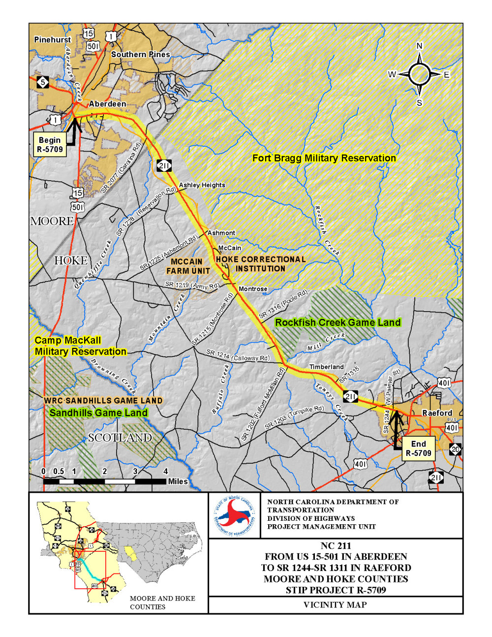
The N.C. Department of Transportation proposes to widen N.C. 211 to a four-lane road divided by a grass median from U.S. 15-501 in Aberdeen (Moore County) to West Palmer Street / Mockingbird Hill Road ) in Raeford (Hoke County), a distance of approximately 15.4 miles.
The project will reduce traffic congestion and travel delays, and correct roadway deficiencies.
Vicinity Map:
New Responses to comments and questions received during the public comment period 
Project Purpose/Need
In 2015, traffic volumes along N.C. 211 ranged from 4,200 vehicles per day (vpd) to 13,600 vpd. In 2040, traffic volumes are projected to increase more than 60 percent, ranging from 6,900 vpd to 22,300 vpd. By 2040, almost all segments of N.C. 211 in the study area will exceed the roadway’s capacity during peak travel time. Without improvements, congestion will continue to grow and lead to increased travel delays.
Within the project limits, N.C. 211 does not meet the current design speed due to the existing vertical alignment (sags and crests) and the existing horizontal alignment (curve). The project will correct those deficiencies while addressing narrow travel lanes and shoulders, inadequate clear zones, as well as sight distance problems with intersecting roadways.
Traffic operations for this two-lane roadway are also affected by “following time,” which refers to time spent by vehicles following one another due to the inability to pass. In 2015, the percentage of time spent following (PTSF) was greater than 50 percent for the majority of the project limits. By the year 2040, the PTSF is expected to be greater than 80 percent while the travel time increases and the average travel speed continues to decline.
During a five-year analysis period, 451 crashes were reported along this section of N.C. 211. The total and fatal crash rates along N.C. 211 are higher than the statewide crash rate for similar facilities. Safety concerns are associated with traffic congestion and limited sight distance.
Project Railroad Crossings
N.C. 211 crosses railroad tracks in Aberdeen just east of Central Drive (Moore County) and near Reservation Road in Hoke County. At‑grade rail crossings have the potential for train crashes involving automobiles and pedestrians. Collisions between trains and automobiles/pedestrians are the principal cause of death and injury in the railroad industry. Due to the volume of vehicular traffic, new bridges will carry N.C. 211 over the railroad just east of Central Drive and near Reservation Road, which enhances safety and eliminates the need for trains to sound a warning horn. Also, the Turnpike Road rail crossing in Raeford will be closed as part of the project.
Project Highlights
The existing speed limit along N.C. 211 will not change with the project. In the Town of Aberdeen and Moore County, there is an existing 45 mph posted speed limit which led to use of a 30-foot raised-grass median while the posted speed limit through Hoke County is 55 mph with a proposed 46-foot depressed grass median.
In addition to N.C. 211 being widened from two to four lanes, the project incorporates Reduced Conflict Intersections (RCI), a design sometimes referred to as a superstreet. RCI is used around the state to improve safety by redirecting traffic from the side streets and driveways to turn right. A motorist desiring to cross the road or go in the opposite direction will take a U-turn at designated areas. The design is safer because it reduces the opportunities for vehicles crossing several lanes of traffic to collide with other vehicles. The design also will reduce delays on N.C. 211 during peak travel time and accommodate expected growth in traffic.
Although NCDOT works to minimize the number of homes, businesses and churches affected by a road project, impacts are anticipated with the proposed project. Design review/refinement is currently underway in a continued effort to increase long-term transportation benefits while reducing potential impacts. Human, community and natural resource impacts will also be addressed as part of upcoming environmental studies.
Project History
Proposed widening improvements to N.C. 211 date back to a feasibility study completed in 1990 and updated in 2002. During that time, the project was included in the State Transportation Improvement Program as Project Number R-2592 and was later renamed as Project Number R-5709 when it was incorporated through the Strategic Prioritization. Once the project was funded in the current STIP, the scoping process began and public meetings were held in Aberdeen and Raeford in July 2016.
Public Involvement
Public Meeting #1:
A public meeting was held on Tuesday, July 23, 2019 to present project maps and receive public input.
Public Meeting #2:
A public meeting was held on Thursday, July 25, 2019 to present project maps and receive public input.
Public Meeting Maps
Map 1: U.S. 15-501 to Collinswood Drive
Map 2: Collinswood Drive to Ashemont Road
Map 3: Ashemont Road to St. Matthews Road
Map 4: St. Matthews Road to Raeford
Small Group Meeting Map (March 2020)
Responses to comments and questions received
Related Documents
The proposed project is included in local transportation plans for both Moore County and Hoke County and it is also included in the metropolitan transportation plan for the Fayetteville Area MPO, as listed below.
Project Funding
| Right of Way | $ 59,423,000 |
| Utility Relocation | $ 4,976,458 |
| Construction Costs | $ 230,000,000 |
| Total Costs | $ 264,399,458 |
* Estimated costs are subject to change. Based on 2020-2029 Adopted NCDOT STIP
.
Project Timeline
| Public Meeting 1 | Summer 2016 |
| Public Meeting 2 | Summer 2019 |
| State Environmental Documentation | Summer 2020 |
| Right of Way | Spring 2021 |
| Construction Begins | Summer 2024* |
* Future dates are preliminary and subject to change. Based on adopted 2020-2029 Adopted NCDOT STIP.
Project Comments:
All comments will be taken into consideration as the project progresses.
Comments can be emailed to NC-211-AberdeentoRaeford@publicinput.com
Project Contact Information:
Terry Farr, PE
Senior Project Manager
NCDOT Project Management Unit
1582 Mail Service Center
Raleigh, NC 27699-1582
(919) 707-6017
Project Email Address: nc-211-aberdeentoraeford@publicinput.com
Title VI Feedback
To ensure we’re hearing from a broad set of voices, would you be willing to share (completely anonymously) some information about yourself?
If so, please click here: https://publicinput.com/ncdot-title-vi-form
RESOURCES FOR PROPERTY OWNERS
Although the N.C. Department of Transportation works to minimize the number of homes and businesses displaced by a road project, it is inevitable, in many cases, that a certain amount of private property is needed. The following information explains right of way acquisition and answers questions about the process.
Right-of-Way Brochure Single Page Layout Folleto del Proceso de Adquisición de Bienes Raíces
Right-of-Way Frequently Asked Questions
Right of way Acquisition Process Videos
Page Last Updated- May 4 2026