 Cape Fear Crossing
Cape Fear Crossing
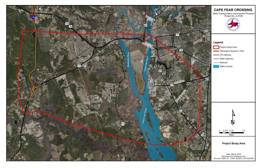
The Cape Fear Crossing is an approximately 9.5-mile proposed road and bridge over the Cape Fear River that would help improve traffic flow and enhance freight movements from U.S. 17 and I-140 in Brunswick County to U.S. 421 near the Port of Wilmington in southern New Hanover County.
U.S. 17 serves as one of the primary entry points into Wilmington from the west, and the Wilmington Urban Area Metropolitan Planning Organization determined that an additional crossing is needed to alleviate congestion on the Cape Fear Memorial Bridge (U.S. 76/U.S. 421/ U.S. 17 Business).
The Cape Fear Crossing would also make it quicker for residents and visitors to evacuate in the event of a hurricane or other emergency situation.
Project Study Area:
Step 1
The six remaining detailed study alternatives are shown below with their general descriptions.
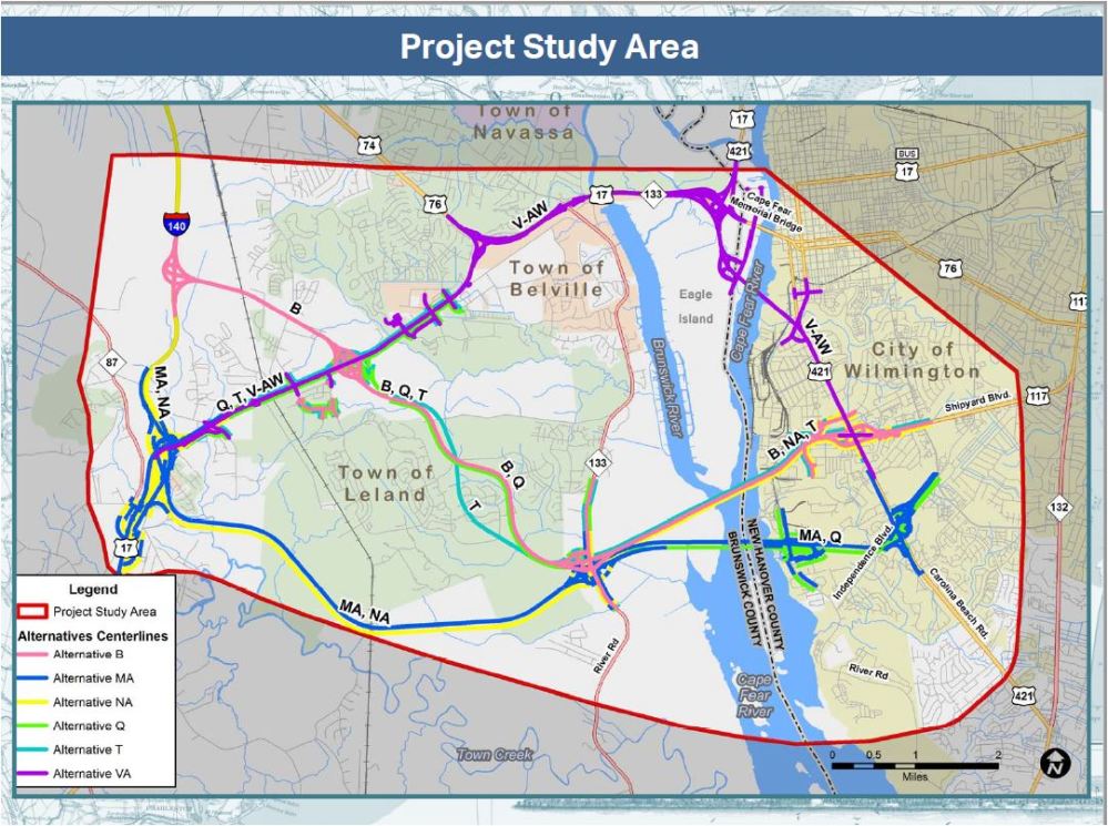
Alternative B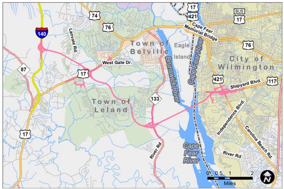
-
This alternative begins at I-140 and crosses U.S. 17
-
Travels between the Brunswick Forest and Mallory Creek developments
-
Crosses the Cape Fear River to end at Shipyard Blvd
-
The bridge will be 215 feet above the navigation channel
-
-
Is approximately 11.1 miles long
-
Is proposed as a four-lane divided freeway for its entirety
-
access will be controlled - no private driveways will be allowed to connect directly to the new roadway
-
-
Interchanges are located at I-140, U.S. 17, N.C. 133, and U.S. 421/Shipyard Blvd.
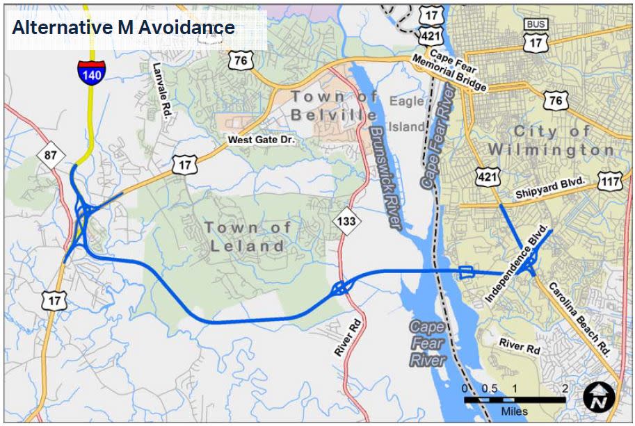
Alternative M - Avoidance
-
ThIs alternative begins at the I-140/U.S. 17 interchange and travels south of Brunswick Forest
-
Crosses the Cape Fear River to end at U.S. 421/Independence Blvd.
-
The bridge will be 215 feet above the navigation channel
-
-
Is approximately 12.3 miles long
-
Includes an interchange at Independence Blvd and U.S. 421, and upgrades U.S. 421 north to Shipyard Blvd
-
Is proposed as a four-lane divided freeway for its entirety
-
access will be controlled - no private driveways will be allowed to connect directly to the new roadway
-
-
Truck ramps will be added at River Rd
-
Interchanges are located at I-140/U.S. 17, N.C. 133, and U.S. 421/Independence Blvd.
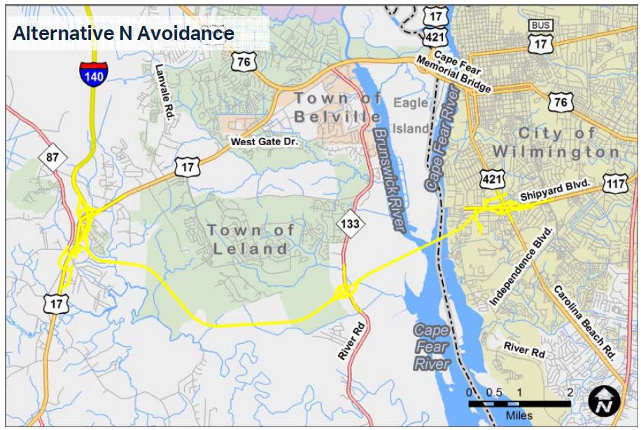
Alternative N - Avoidance
-
Begins at the I-140/U.S. 17 interchange and travels south of Brunswick Forest
-
Crosses the Cape Fear River to end at U.S. 421/Shipyard Blvd
-
The bridge will be 215 feet above the navigation channel
-
-
Is approximately 12.2 miles long
-
Includes an interchange at Shipyard Blvd and U.S. 421.
-
access will be controlled - no private driveways will be allowed to connect directly to the new roadway
-
-
Interchanges at I-140/U.S. 17, N.C. 133, and U.S. 421/Shipyard Blvd.
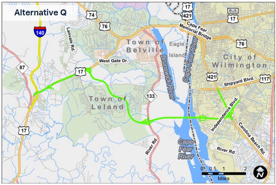
Alternative Q
-
Begins at the I-140/U.S. 17 interchange
-
Upgrades existing U.S. 17 for approximately 2 miles, then continues on new location between the Brunswick Forest and Mallory Creek developments
-
Crosses the Cape Fear River to connect at U.S. 421/Independence Blvd
-
The bridge will be 215 feet above the navigation channel
-
-
Upgrades U.S. 421 from Independence Blvd to Shipyard Blvd, where it ends
-
Is approximately 11.5 miles long
-
Is proposed as a six-lane arterial widening typical section on U.S. 17 and a four-lane freeway typical section on new location
-
Truck ramps will be added at River Rd
-
Interchanges at U.S .17, N.C.133, and U.S. 421/Independence Blvd.
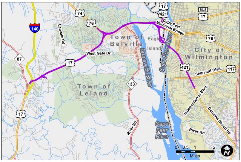
Alternative V-AW
-
Begins at the I-140/U.S. 17 interchange, upgrading U.S. 17 to the U.S. 17/U.S. 421 interchange
-
Travels south along Eagle Island on new location
-
Crosses the Cape Fear River to end at U.S. 421 and Shipyard Blvd
-
The bridge will be 135 feet above the navigation channel
-
-
Is approximately 11.8 miles long
-
Is proposed as a six to eight-lane arterial widening typical section (depending on location) on U.S. 17 and a four-lane widening freeway typical section on new location
-
Interchanges at U.S. 74/76/17, Battleship Road, and U.S. 421.
Alternative T
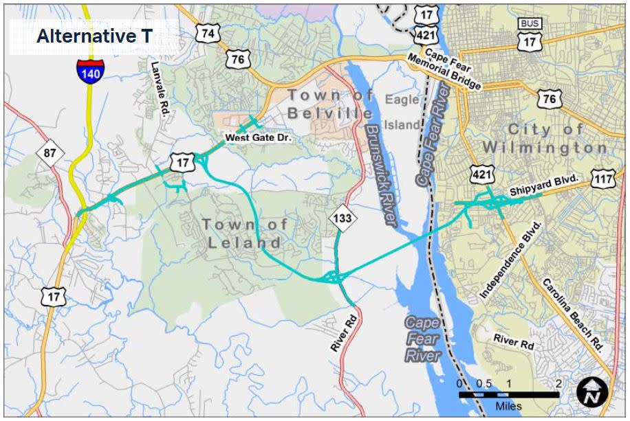
-
Begins at the I-140/U.S. 17 interchange
-
Upgrades existing U.S. 17 for approximately 2 miles, then continues on new location parallel to Wire Road
-
Crosses the Cape Fear River to end at U.S. 421/Shipyard Blvd
-
The bridge would be 215 feet above the navigation channel
-
-
Is approximately 11.4 miles long
-
Is proposed as a six-lane arterial widening typical section on U.S. 17 and a four-lane freeway typical section on new location
-
Interchanges at U.S. 17, N.C. 133, and U.S. 421.
RESOURCES FOR PROPERTY OWNERS
Although the N.C. Department of Transportation works to minimize the number of homes and businesses displaced by a road project, it is inevitable, in many cases, that a certain amount of private property is needed. The following information explains right of way acquisition and answers questions about the process.
Relocation Assistance Brochure Asistencia para Reubicación
Right-of-Way Acquisition Process Brochure Folleto del Proceso de Adquisición de Bienes Raíces
Right-of-Way Frequently Asked Questions