R-5830 - Deerfield Road Improvements - Watauga County
R-5830 - Deerfield Road Improvements - Watauga County
The N. C. Department of Transportation proposes improvements to Deerfield Road from State Farm Road to just west of Wilson Ridge Road in Watauga County.
Open House Public Meeting
_____________________________________________
August 6, 2024
Boone Loyal Order of Moose Lodge
607 Deerfield Road, Boone
4:00 p.m. to 7:00 p.m.
No formal presentation will be made
_____________________________________________
Project Vicinity Map
Project Overview
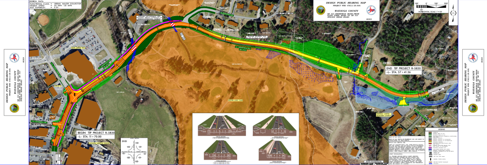
State Transportation Improvement Program (STIP) Project No: R-5830 proposes improvements to Deerfield Road from State Farm Road to just west of Wilson Ridge Road. Improvements include:
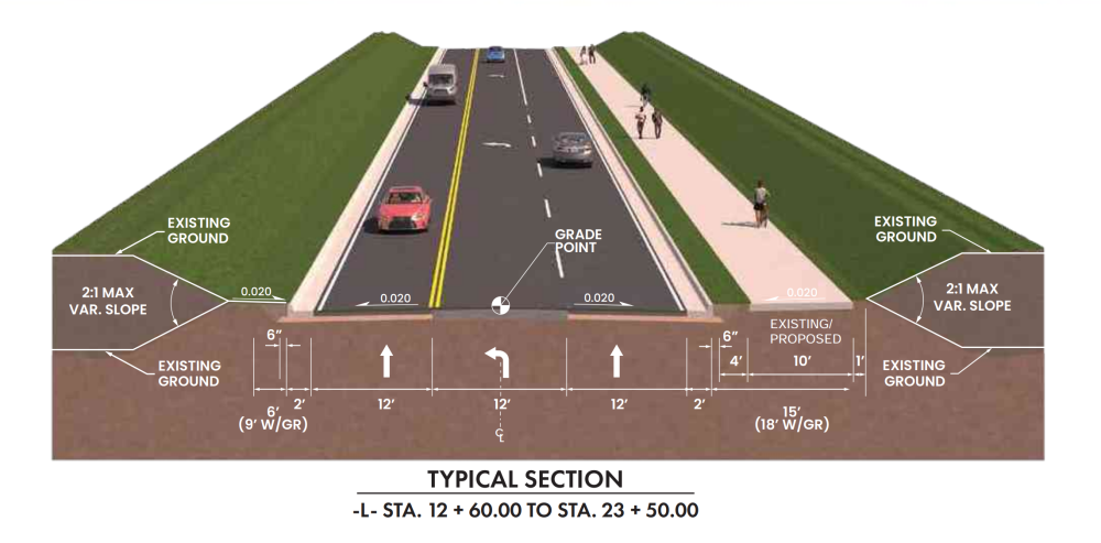
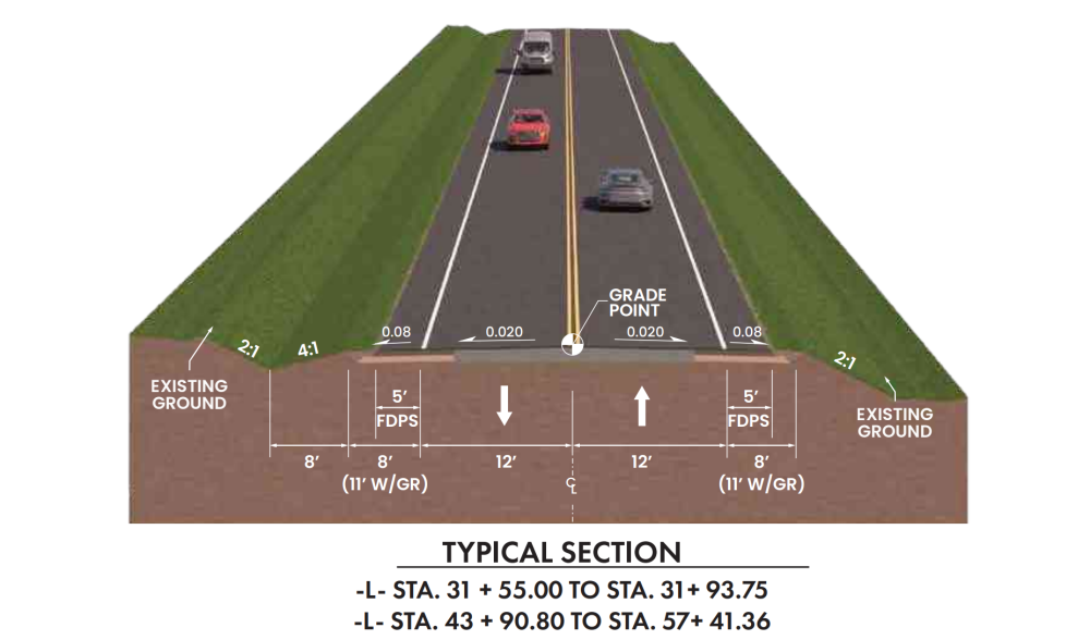
widening the existing 10-foot-wide travel lanes to 12 feet with 5-foot-wide paved shoulders,
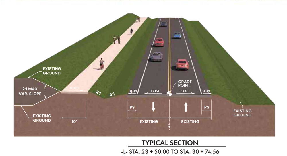
constructing a section of multi-use path,
upgrading the Deerfield Road/State Farm Road intersection
The project is approximately 0.85 miles long and will tie into an adjacent project (STIP Project No. U-581) which proposes to improve Wilson Ridge Road and Bamboo Road and construct a roundabout at the Deerfield Road/Wilson Ridge Road intersection, east of the R-5830 project limits.
Project Highlights
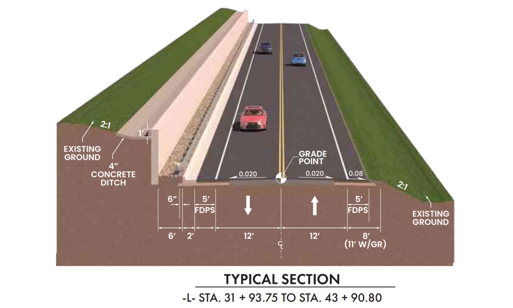
Widen the existing 10-foot-wide travel lanes to 12 feet including 5-foot-wide, full-depth paved shoulders to accommodate bicycles
Upgrade the Deerfield Road/State Farm Road intersection by:
- adding turn lanes on westbound Deerfield Road onto northbound State Farm Road and into the Watauga Medical Center (WMC),
- adding a dedicated through lane; and,
- Increasing the storage capacity of the left turn lane on eastbound Deerfield Road, thereby improving the functionality of the intersection
Include crosswalks and pedestrian signals at the Deerfield Road/State Farm Road intersection to maintain a safe and accessible connection between the ASU Health Sciences building, the WMC, and other nearby land uses, as well as between the Boone Connector (a portion of the planned Middle Creek Greenway) and the Boone Greenway, accessed from the existing parking area on the north side of the roadway
Extend MUP on the north side of the project corridor from the Deerfield Road/State Farm Road intersection to Blairmont Drive including the construction of two separate 50-foot-long pedestrian bridges over both the Middle Fork and East Fork South Fork New River; Hydraulic modeling analysis is currently underway and scheduled to be completed late Summer 2024 to determine if construction of the pedestrian bridges is possible without altering the hydrology of the surrounding area
Correct horizontal and vertical curve deficiencies along the length of the project to improve sight distance, including roadway realignment west of the Yates Cove intersection
Planned improvements are consistent with recommendations in local and state transportation plans and local input and the project design includes facilities to accommodate the growing pedestrian, bicycle and transit needs of the surrounding designated Wellness District area and along Deerfield Road
Access will be maintained to existing driveways to adjacent land uses and intersecting roadways along the project corridor
A retaining wall will be utilized along the middle portion of the project corridor.
Project History
The Watauga County Comprehensive Transportation Plan (2017) (CTP) indicates that by 2040, a small section of Deerfield Road will be over capacity. The plan cites the presence of the WMC, and the 25-mph posted speed limit in this area as contributing factors. The plan also projects that State Farm Road will be over capacity by 2040 from NC 105 to Deerfield Road and that improvements are needed to retain LOS D. Improvements are proposed to consist of a two- and three-lane, curb and gutter section with wide outside lanes to accommodate bicycles.
Planned improvements are consistent with recommendations in local and state transportation plans and local input. Deerfield Road and State Farm Road are identified in the Watauga County Comprehensive Transportation Plan (2017) (CTP) as ‘Minor Thoroughfares’ in need of improvement regarding pedestrian, bicycle, and transit infrastructure. The CTP and the High Country Regional Bike Plan (2014) propose that Deerfield Road be widened to include 12-foot travel lanes with 4-foot paved shoulders to accommodate bicycles. The CTP also recommends construction of multi-use paths that would intersect the project corridor at the current greenway parking lot access and the construction of sidewalks from the western project terminus to Blairmont Drive.
The Town of Boone Pedestrian and Bicycle Plan (2014) recommends shared lane markings (sharrows) from the western project terminus eastward to the current municipal limits and wide paved shoulders from that point to the eastern project terminus. The plan also calls for sidewalks from the western project terminus to Blairmont Drive. 10-foot sidewalks have been constructed along Deerfield Road as a component of the Leon Levine College of Health Science Building development. According to the Planning Department, this section of sidewalk will accommodate the expected increase in pedestrian traffic in the area and provide connectivity to the existing Boone Greenway and the extension of the Middle Fork Greenway through and adjacent to the Watauga Medical Center campus. A portion of this greenway has been constructed on the east side of Deerfield Road adjacent to the WMC.
Project Funding:
Activity | Costs* |
Project Development & Design | $ TBD |
Right Of Way Acquisition | $ 5.8 Million |
Construction | $ 6.2 Million |
Total Cost | $ 13.2 Million |
*costs are subject to change.
Project Timeline:
Milestone | Date* |
Environmental Document | Fall 2024 |
| Right Of Way Aquisition | February 2025 |
Construction Begins | September 2027 |
* Future dates subject to change.
Comments:
NCDOT accepts comments throughout all phases of project development.
All comments will be taken into consideration, and carry equal weight, regardless of submittal method.
To submit comments for consideration during the current phase of project development,
please submit by August 27, 2024.
The public is encouraged to leave comments using this webpage, email, or phone , or by U.S. Mail to the project contacts below.
Email: Deerfield-Road-Improvements@publicinput.com
Phone Number: 984-205-6615 enter project code 6167 to leave a message
PROJECT CONTACT INFORMATION
Heath Slaughter
Division Project Manager
NCDOT Highway Division 11
801 Statesville Road
North Wilkesboro, NC 28659
PROJECT CONTACT INFORMATION
Roman Prokopovych, P.E.
Senior Project Delivery Leader
RK&K
124 Floyd Smith Office Park Drive, Suite 240
Charlotte, NC 28262
RESOURCES FOR PROPERTY OWNERS
Although the N.C. Department of Transportation works to minimize the number of homes and businesses displaced by a road project, it is inevitable, in many cases, that a certain amount of private property is needed. The following information explains right of way acquisition and answers questions about the process.
Right-of-Way Brochure Single Page Layout Folleto del Proceso de Adquisición de Bienes Raíces
Right-of-Way Frequently Asked Questions
Right of way Acquisition Process Videos
Title VI Feedback
To ensure we’re hearing from a broad set of voices, would you be willing to share (completely anonymously) some information about yourself?
If so, please click here https://publicinput.com/NCDOT-Title-VI
