I-5987: I-95 Widening
I-5987: I-95 Widening
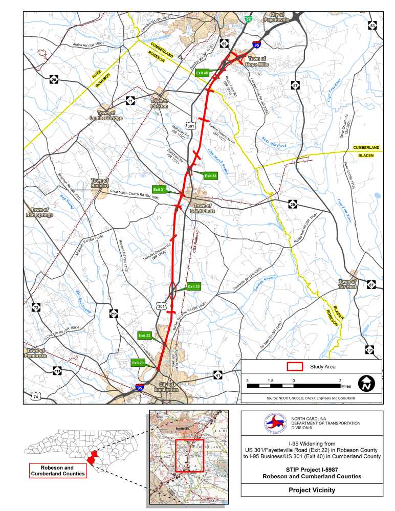
The proposed project involves widening a 15.7-mile segment of I-95 from south of U.S. 301 (Exit 22) to north of S.R. 1732 (Parkton Tobemory Road) in Robeson County. The primary purpose of this project is to help relieve congestion and maintain the resiliency of this corridor such that it can continue to serve as a primary East Coast route through the project design year of 2040.
Vicinity Map:
Project Overview:
Improvements along I-95 will be required to accommodate projected future traffic volumes and ensure the highway operates at an acceptable level of traffic service, particularly during peak hours. Traffic volumes along the I-95 corridor are expected to increase considerably by 2040, creating conditions in which operations degrade and average travel speeds are below the posted speed limit. The proposed widening project would increase the capacity of the roadway to improve the flow of traffic and lessen delays from congestion.
Proposed Improvements Include:
Addition of two travel lanes in each direction, bringing the total number of lanes in this section from four to eight.
Existing bridges at interchanges, overpasses, and stream crossings along the corridor will need to be replaced to accommodate the widened facility.
For most of the project, the existing grass median will be reduced to a width of 27 feet, including 12-foot inside paved shoulders for each travel direction and a three-foot concrete median (jersey) barrier. This narrowed median will enable the widening to occur primarily within the existing NCDOT right of way, therefore minimizing impacts to private property along the interstate.
Public Involvement
Public Meeting #1:
A public meeting was held on Monday, July 22, 2019 at Robeson Community College to present project maps and receive public input.
Public Meeting #2:
A public meeting was held on Tuesday, July 23, 2019 at Gray's Creek Middle School in Hope Mills to present project maps and receive public input.
Public Meeting Maps:
Map 1: NC 211/N Roberts Avenue (Exit 20), Dawn Drive, Kahn Drive, and U.S. 301/Fayetteville Road (Exit 22)
Map 2: Powersville Road, NCDOT Weigh Station
Map 3: U.S. 301 (Exit 25), Russ Road, Bucket Road
Map 4: McDuffie Crossing Road
Map 5: Cedar Grove Church Road, Great Marsh Church Road, NC 20/Broad Street (Exit 31)
Map 6: U.S. 301 (Exit 33), Oakland Road
Map 7: McRainey Road
Map 8: Parkton Tobermory Road, Buckhorn Road, Future Fayetteville Outer Loop, Green Springs Road
Map 9: Roslin Farm Road, Braxton Road, I-95 Business/U.S. 301 (Exit 40)
Project Funding:
This project is listed as Project No. I-5987 in the N.C. Department of Transportation's State Transportation Improvement Program (STIP) and is funded for $448 million.
| Estimated Amount* |
|---|---|
Project Development & Design | $ 10,000,000 |
Right-of-Way | $ 7,000,000 |
Utility Relocation | $ 3,000,000 |
Construction Costs | $ 532,000,000 |
Total Costs | $ 552,000,000 |
* Estimated costs are subject to change. Based on draft NCDOT STIP.
Project Timeline:
Milestone | Date* |
|---|---|
Public Meetings | July 22 & 23, 2019 |
Environmental Documentation | September 2019 |
Right-of-Way | May 28, 2021 |
Construction | I-5987B Let Date July 19, 2022
I-5987A Let Date September 20, 2022 |
* Future dates are preliminary and subject to change
Project History:
An Initial Project Kickoff Meeting was held between NCDOT, the Lumber River Rural Planning Organization, and project consultants in May 2018. The primary topics discussed at this meeting were general design concepts, known environmental constraints, project scheduling, and planning of coordination efforts between NCDOT, other government agencies, and the public. Start of Study Letters were distributed in December 2018 to state and federal agency representatives, along with those from Robeson County, Cumberland County, and municipalities along the project corridor. The letters outlined the proposed project improvements to these local officials, provided mapping of the project area, and invited comments to guide project development.
An Agency Introduction Meeting was conducted with representatives from NCDOT, the N.C. Division of Water Resources, and the U.S. Army Corps of Engineers in January 2019. This meeting focused on environmental resources within the project area and potential avoidance and mitigation measures for minimizing impacts to these features. A Project Newsletter was mailed to residents and property owners in the project area in May 2019. The newsletter included information on the proposed improvements, current project schedule, and invited comments to project representatives. Functional Roadway Designs were developed using data collected during the initial development process and approved by NCDOT in May 2019.
Project Comments:
NCDOT accepts comments throughout all phases of project development.
The public comment period for the above portion of the project development process closed on August 23, 2019.
All comments received have been taken into consideration.
Project Contact Information:
Craig Freeman, P.E.
NCDOT Division 6 Project Manager
P.O. Box 1150
Fayetteville, NC 28302
(984) 205-6615 project code 4633
Project Email Address: I-95-Widening@publicinput.com
RESOURCES FOR PROPERTY OWNERS
Although the N.C. Department of Transportation works to minimize the number of homes and businesses displaced by a road project, it is inevitable, in many cases, that a certain amount of private property is needed. The following information explains right of way acquisition and answers questions about the process.
Right-of-Way Brochure Single Page Layout Folleto del Proceso de Adquisición de Bienes Raíces
Right-of-Way Frequently Asked Questions
Right of way Acquisition Process Videos

