Water Quality Benefits Evaluation Toolkit – SUSTAIN
Water Quality Benefits Evaluation Toolkit – SUSTAIN
King County is committed to making big investments in water quality over the next decade. The Water Quality Benefits Evaluation (WQBE) Toolkit will support the County in identifying water quality improvements that are effective at reducing pollutants and improving ecological and human health.
System for Urban Stormwater Treatment and Analysis Integration (SUSTAIN) models identify cost-effective combinations of potential water quality Actions to reduce stormwater pollutant loads or volumes. This helps us develop and implement plans for flow and pollution control measures to protect source waters and meet water quality goals. SUSTAIN allows watershed and stormwater practitioners to develop, evaluate, and select optimal best management practice (BMP) actions and Packages at various watershed scales based on cost and effectiveness.
Thank you to those of you who provided feedback on the SUSTAIN models in June-July 2021! Please visit the tabs below for updates on the models and stay tuned for a future webinar.
How to use this site
Visit each tab to learn more about the models. All information presented here is subject to change as the models are further refined.
Overview
Overview
What are SUSTAIN models?
The System for Urban Stormwater Treatment and Analysis Integration (SUSTAIN) was developed by the Environmental Protection Agency (EPA) between 2003-2013. SUSTAIN was customized for Puget Sound watersheds by EPA Region 10 in 2013 and officially released in January 2014. The SUSTAIN models identify cost-effective combinations of “Actions” and “Packages” for reducing stormwater pollutant loads or volumes. Here is an FAQ that describes what SUSTAIN does.
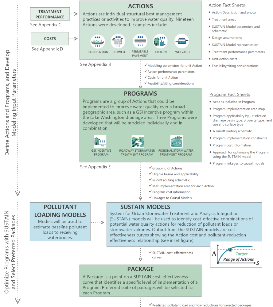
- Action: individual structural and non-structural best management practices (BMPs) or activities to improve water quality (e.g., rain gardens, wetponds, street sweeping).
- Program: a group of Actions that could be implemented to improve water quality over a broad geographic area.
- Package: a point on a SUSTAIN cost-effectiveness curve that identifies a specific level of implementation of a Program (e.g., 200 unit rain gardens and 50 unit permeable pavement installations in specified subbasins that represent a cost-effective implementation of a Green Stormwater Infrastructure [GSI] incentive program in the Lake Washington basin).
Programs will be evaluated with the SUSTAIN models by generating a Package of representative Actions optimized for stormwater volume or pollutant load reductions at an assessment point. The figure below illustrates how these components fit together for modeling through SUSTAIN. Action and Program Fact Sheets are available for review on the following tabs of this site, as well as a technical memorandum that includes detailed appendices documenting the methods, data sources, and underlying assumptions for each component as shown below.
Watch an overview presentation about the SUSTAIN models from the June 22, 2021 webinar presented by John Riverson (SUSTAIN modeling lead).
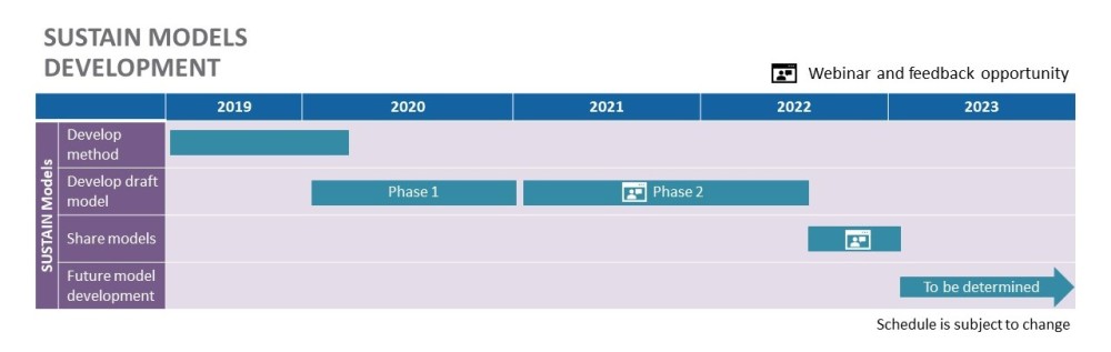
TIMELINE FOR WQBE SUSTAIN MODEL DEVELOPMENT
Why are we developing SUSTAIN models?
SUSTAIN is a decision support tool that assists stormwater management professionals with developing and implementing plans for flow and pollution control measures to protect source waters and meet water quality goals. SUSTAIN allows watershed and stormwater practitioners to develop, evaluate, and select optimal best management practice (BMP) combinations at various watershed scales based on cost and effectiveness.
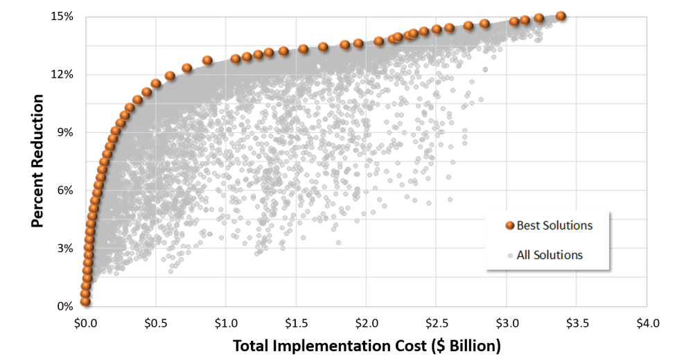
SUSTAIN can be used to perform hydrologic and water quality modeling in watersheds and urban streams. It identifies cost-effective management solutions at multiple-scale watersheds to achieve desired water quality objectives based on cost effectiveness. It provides answers to the following questions when developing plans:
- How effective are Actions (e.g., stormwater BMPs) in reducing runoff and pollutant loadings?
- What are the most cost-effective combinations of Actions for meeting water quality objectives?
- Where, what type, and what quantity of Actions are needed to meet a specific performance target and how much would it cost?
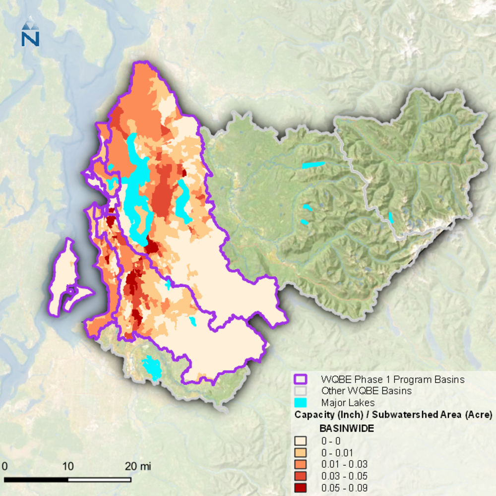
The figure below provides an example of a heat map that can be generated to show where different types of Actions should be concentrated to meet a water quality objective.
Heat map of inches of runoff managed (total treatment capacity) per catchment for a specific Package of Actions on the cost effectiveness curve.
How will the SUSTAIN models be used?
Preliminary outputs from SUSTAIN have helped inform planning-level cost and performance estimates for potential stormwater programs for County planning efforts like the Clean Water Plan and the combined sewer overflow (CSO) control program. We are now moving to leverage these models to support basin prioritization and implementation planning within the County's Stormwater Services Section. We also think these models could be useful for partners, such as Phase 2 jurisdictions working on their Stormwater Management Action Plan (SMAP) permit requirements. We expect to continue refining these models over time as we learn more about regional priorities for water quality.
The review period for this model ended in July 2021. If you have questions or comments, please contact Stephanie Truitt.
Click continue to learn more about the Actions and Programs included in SUSTAIN modeling.