 HL-0006: U.S.401 - Hilltop Needmore
HL-0006: U.S.401 - Hilltop Needmore
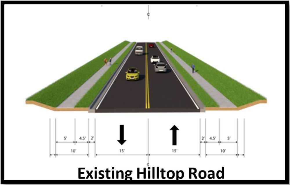
The N.C. Department of Transportation proposes to improve the intersection of U.S. 401 at Hilltop Needmore Road/Airpark Road in southern Wake County. The project would also make changes to Hilltop Road south of the intersection.
Step 1
 Responses to questions and comments received posted - they can be accessed here
NCDOT preferred alternative selected: Alternative 2 (Curb & Gutter), with Option B (reverse RCI)
Interactive Project Area Map:
PROJECT OVERVIEW VIDEO
History
The Strategic Transportation Investments (STI) law includes a provision for a funding allocation to local governments based on funding contributed by the local government to transportation projects or revenue from tolling. This bonus allocation can be used to fund the construction of other eligible highway projects.
Early in 2020, the Capital Area Metropolitan Planning Organization (CAMPO) received notice from NCDOT that there would be a bonus allocation to CAMPO from the N.C. 540 (toll road) project. This project, at the intersection of U.S. 401 and Hilltop Needmore Road/Airpark Road, was one of several selected by CAMPO for the bonus allocation funding. NCDOT began project development work for the project in early 2021.
Project Overview
This project proposes an alternative intersection design at the U.S. 401 / Hilltop Needmore Road / Airpark Road / Hilltop Road location. Proposed designs will be a Reduced Conflict Intersection (RCI) or a Reverse RCI at this location. The project would also realign Hilltop Road to intersect U.S. 401 opposite Lake Wheeler Road with an RCI.
Two Alternatives are being considered, and each alternative has two Options.
Both alternatives propose:
- Reduced conflict intersection or Reverse Reduced Conflict Intersection at U.S. 401/Hilltop Needmore Road/Airpark Road
- Cul-de-sac of existing Hilltop Road at Airpark Road Intersection
- Reduced conflict intersection at U.S. 401/Lake Wheeler Road
- New roadway connection from existing Hilltop Road to U.S. 401 aligned with Lake Wheeler Road
- Leftover access to Dwight Rowland Rd
- 10-foot-wide multi-use path on the south side of new roadway connection Hilltop Road and East side of U.S. 401
- 5-foot-wide sidewalk on north side of realigned Hilltop Road and West side of U.S. 401
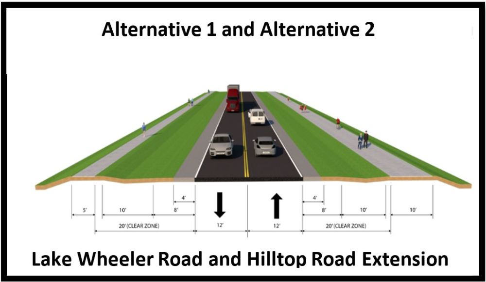
The following section provides the typical cross sections for the roadway proposals.
The left side shows Alternative 1 and the right side shows Alternative 2.
Clicking on the individual photographs will open them in larger format for ease of viewing.
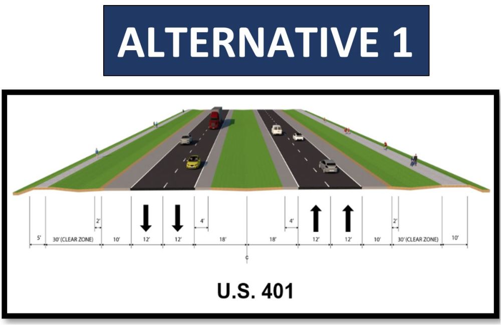
- two 12-foot lanes in each direction
- a 36-foot depressed median
- 4-foot graded shoulders on the inside
- 10-foot graded shoulders on the outside
- a 5-foot sidewalk on the west side
- a 10-foot multi-use path on the east side
- a 30-foot clear zone between the shoulder and the sidewalk/multi-use path
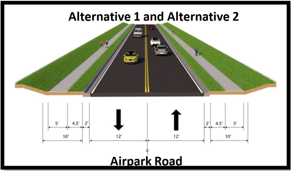
- One 12-foot lane in each direction
- a 4-foot graded shoulder section and 4-foot natural shoulder section on each side
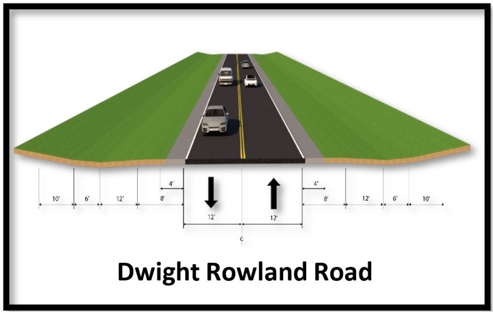
- One 12-foot lane in each direction
- a 4-foot graded shoulder section and 4-foot natural shoulder section on each side
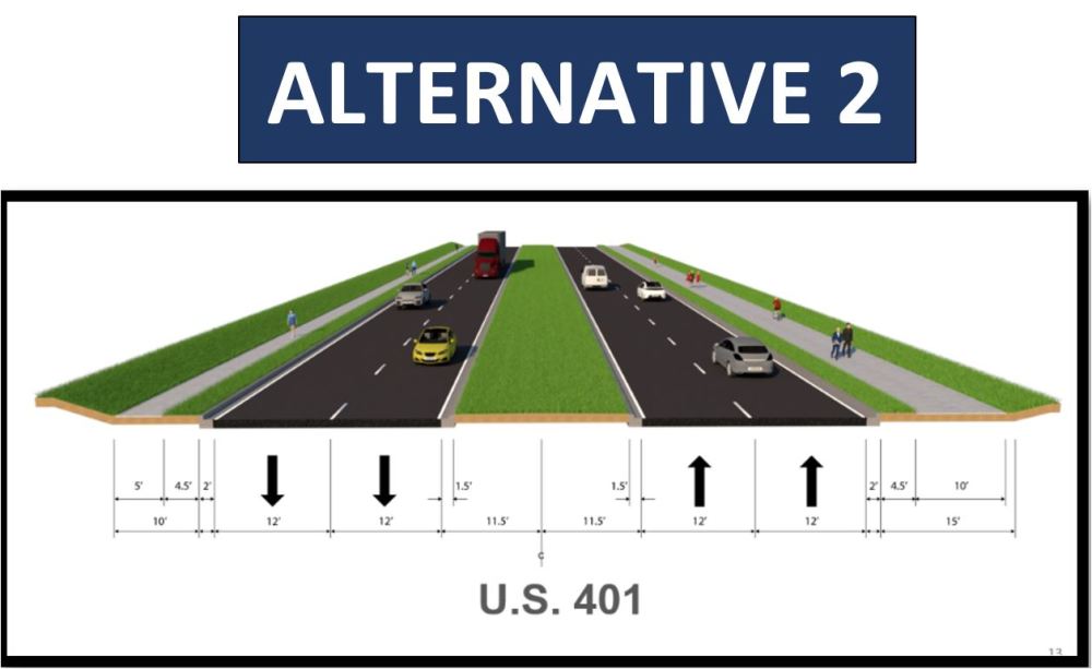
- two 12-foot lanes in each direction
- a 23-foot raised median between
- curb and gutter on each side
- a 5-foot sidewalk on the west side
- a 10-foot multi-use path on the east side
- a 4.5-foot clear zone between the back of curb and the sidewalk/multi-use path
- One 15-foot lane in each direction
- Curb and Gutter on each side
- a 10-foot Multi-use path on one side of the new roadway and a 5-foot sidewalk on the other
- a 4.5-foot clear zone between the back of curb and the sidewalk/multi-use path
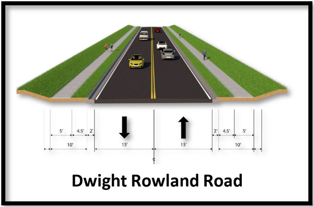
- One 15-foot lane in each direction
- Curb and Gutter on each side
- a 5-foot sidewalk on the both sides of the roadway
- a 4.5-foot clear zone between the back of curb and the sidewalk/multi-use path
Alternatives 1 and 2 are the same for Airpark Road,
Lake Wheeler Road and Hilltop Road Extension.
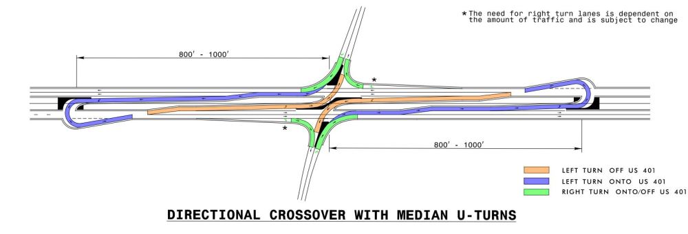
Reduced Conflict Intersections
The most common type of reduced conflict intersection design eliminates left turns from side roads onto busy main roads.
Raised medians direct traffic from the side road into turning right. When there is a safe opening in traffic, drivers enter the flow of traffic on the main route. To go the other direction, or cross the highway, they pull into a dedicated lane – typically less than 1,000 feet away – and make a U-turn. There may be a traffic signal at this location.
A reverse reduced conflict intersection uses raised medians to allow traffic from the side road to turn left. A median prevents traffic on the mainline (U.S. 401) traffic from turning left at the intersection. Traffic desiring to turn left would pull into a dedicated lane – typically less than 600 feet away – and make a U-turn. There may be a traffic signal at this location.
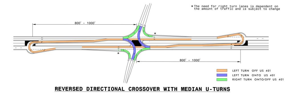
To view a video on Reduced Conflict Intersections (RCI), visit: Reduced-Conflict-Intersections
Project Maps
Download PDF of Project Maps
Alternative 1
Alternative 2
For additional information on how to read a public meeting map, click here.
Project Funding
| Estimated Amount Alt-1* | Estimated Amount Alt-2* |
| Right-of-Way and Utilities | $3,509,000 | $6,800,000 |
| Construction | $22,700,000 | $53.1 Million |
| Total Cost | $26,209,000 | $59.9 Million |
* Estimated costs are subject to change. Based on October 8, 2025 cost Estimate.
Project Timeline
Milestone | Date* |
| Environmental Document | May 2023 |
| Right of Way Acquisition | Fall 2023 |
| Construction Begins | October 2027 |
* Future dates are preliminary and subject to change
PROJECT CONTACT INFORMATION
John W. Braxton
Senior Project Manager
NCDOT Highway Division 5
1573 Mail Service Center
Raleigh, NC 27699-1573
COMMENTS/QUESTIONS
Comments may be submitted at any meeting, below, via phone (984-205-6615 code 5220)
email (US401-HilltopNeedmore@PublicInput.com)
or U.S. Mail to the Project Manager listed above.
NCDOT accepts comments throughout all phases of project development.
All comments received carry equal weight, regardless of submission method.
All comments will be reviewed and suggestions/recommendations
incorporated into designs where feasible.
Title VI Feedback
To ensure we’re hearing from a broad set of voices, would you be willing to share (completely anonymously) some information about yourself?
If so, please click here https://publicinput.com/NCDOT-Title-VI-Form
RESOURCES FOR PROPERTY OWNERS
Although the N.C. Department of Transportation works to minimize the number of homes and businesses displaced by a road project, it is inevitable, in many cases, that a certain amount of private property is needed. The following information explains right of way acquisition and answers questions about the process.
Right-of-Way Brochure Single Page Layout Folleto del Proceso de Adquisición de Bienes Raíces
Right-of-Way Frequently Asked Questions
Right of way Acquisition Process Videos
Page last updated: July 6, 2026