Phase 2 - Workshop #2 Neighborhoods & Housing
Phase 2 - Workshop #2 Neighborhoods & Housing
This component of Phase 2 is focused on reviewing and updating the 2010 land use recommendations for Crozet’s neighborhoods and residential areas.
Together, we’ll work to clarify appropriate form and scale for infill development in aging neighborhoods and develop a shared understanding about how neighborhoods should transition from centers of activity like Downtown and Starr Hill/Music Today. We are planning on a 20-year horizon, so as you answer these questions, we invite you to envision the future of Crozet’s neighborhoods – don’t feel limited by what exists today!
Introduction
A Master Plan is a collaboratively developed document that describes a community’s vision for future development, using text, maps and diagrams. In Albemarle County, Master Plans are used to guide future public and private development and to coordinate and prepare more detailed plans.
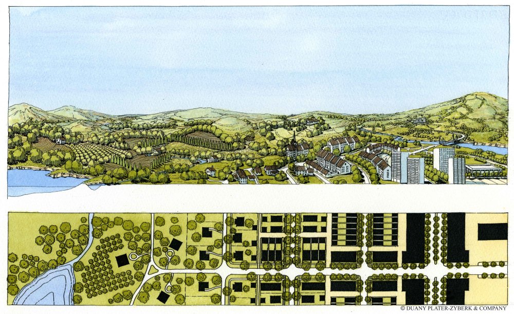
During this master planning process, we invite you to think about the “uses” that occur in different areas of Crozet. Examples of Future Land Uses include residential, commercial, light industrial, open space/parks and even mixed-use. Additionally, we invite you to think about the scale or intensity of development across different areas of Crozet.
Below is a planning graphic that shows different scales of development as it transitions from rural to urban:
During the February 6th Housing Workshop, staff and community members discussed neighborhoods and other residential areas across Crozet. If you couldn’t attend or have additional thoughts you’d like to contribute, fill out this online questionnaire to share your perspective!
We expect this questionnaire to take around 15-20 minutes to fill out. We've divided it into sections with questions specific to different geography areas in Crozet:
- Western Crozet: Includes Jarman’s Gap Road corridor west of Downtown, including Old Trail, Blue Ridge Avenue, Orchard Acres, Wayland’s Grant, Bargamin Park, Grayrock and Jarman’s Gap Estates
- Eastern Crozet: Neighborhoods east of Crozet Park and Starr Hill, including Brookwood, Westhall, Westlake Hills, Foothill Crossing, Western Ridge, Emerson Commons, Wickham Pond and Highlands
- Southern Crozet: Neighborhoods along the Crozet Avenue corridor south of Park Road including Park View, White Oaks, Chesterfield Landing, and the Meadows; Route 250 corridor including Brownsville Road, Sparrow Hill, Cory Farm, Liberty Hall and Clover Lawn
- Northern Crozet: Downtown and adjacent neighborhood north of the railroad as well as the Hill Top Street/High Street area and Parkside Village
Each response is recorded individually. If you can’t respond to every question all at once, you can come back at any time and resume. Alternatively, if you’d only like to answer questions for one geographic area of Crozet, you can do so.
Glossary of Terms (Phase 2)
Master Plan: A policy document providing a long range vision for land use and development, transportation, and parks and green systems for one of the County's Development Areas. Master Plans typically contain narrative text, maps, a vision statement, recommendations, and implementation steps to guide future development and investment within the Master Plan area.
Land Use Designation: Land Use Designations, or "land uses" set a long-range vision for a specific property and illustrate the expectations for future use and development patterns for land within the County. Land Use Designations typically include descriptions and recommendations for future uses on a property (such as office, residential, commercial, mixed-use) and some guidance on building form such as height, massing, and density. Land Use Designations are found in the Comprehensive Plan and do not carry the force of law, but can inform decisions on future policy changes such as zoning map or zoning text amendments.
Zoning: Most cities and counties have rules about what you can build and where. What a property owner can build depends on where – or what zoning district – their property is located within. Albemarle County uses zoning to group land into different areas – or zones – to protect the health, safety and wellbeing of its community members. Zoning carries the force of law and establishes regulations for each property in the County.