 HB-0039: Cape Fear Memorial Bridge
HB-0039: Cape Fear Memorial Bridge
The N.C. Department of Transportation is proposing replacement of the Cape Fear Memorial Bridge in Brunswick and New Hanover Counties.
Step 1
This page is intended to provide information and accept public comment/questions on the Cape Fear Memorial Bridge Replacement Project.
For additional information, please visit the NCDOT webpage:
https://www.ncdot.gov/projects/cape-fear-bridge-replacement/Pages/default.aspx

Responses to questions and comments received during the public comment period are available here.
Project Overview
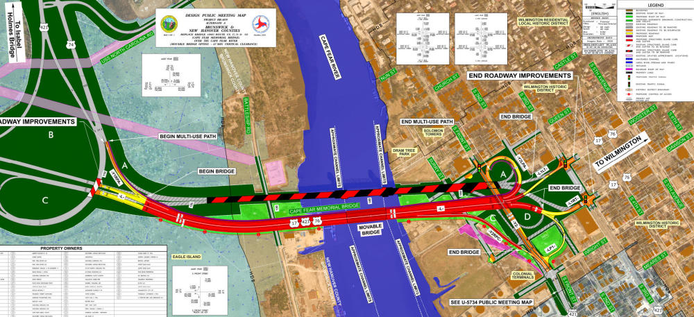
Planning and development are underway to replace the Cape Fear Memorial Bridge in Wilmington. The 0.66-mile bridge carries U.S. 17/U.S. 76/U.S. 421 across the Cape Fear River between Brunswick and New Hanover counties.
The bridge replacement would help improve traffic congestion and mobility on a corridor that connects local communities and carries trucks transporting freight to and from the Port of Wilmington.
Built in 1969, the existing four-lane, steel vertical-lift bridge is becoming functionally obsolete (a bridge that can no longer effectively service current traffic demands).
While the existing bridge is safe, it is reaching the end of its lifecycle and must be monitored, inspected and maintained on a more frequent basis.
Traffic delays due to repair and maintenance activities and the operation of the bridge lift cause congestion and make travel times unreliable. The existing bridge also lacks bicycle and pedestrian lanes to support other modes of transportation.
For additional information on the project, please visit the NCDOT webpage:
https://www.ncdot.gov/projects/cape-fear-bridge-replacement/Pages/default.aspx
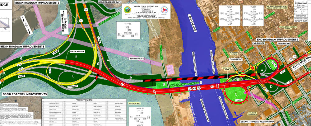
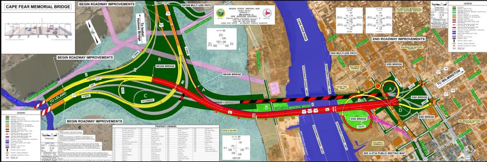
Alternate Maps
Clicking on either the text or pictures below will open the map or typical section in a new window for easy viewing (zoom control) or downloading.
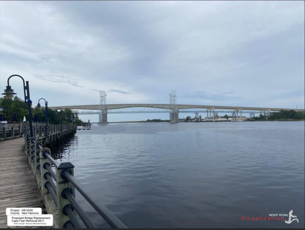
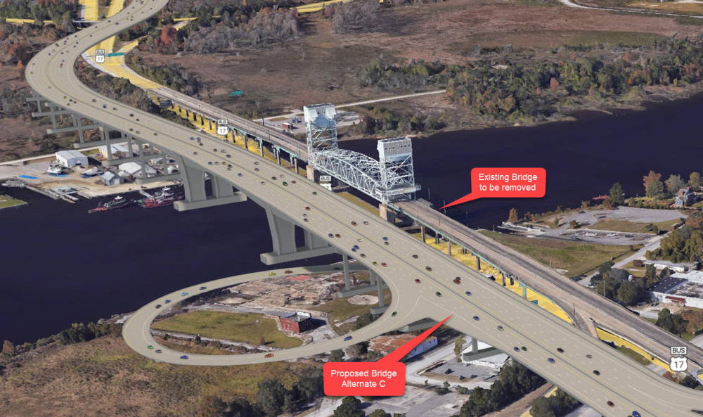
Alternate A
Moveable Structure
65-135 foot Vertical Clearance
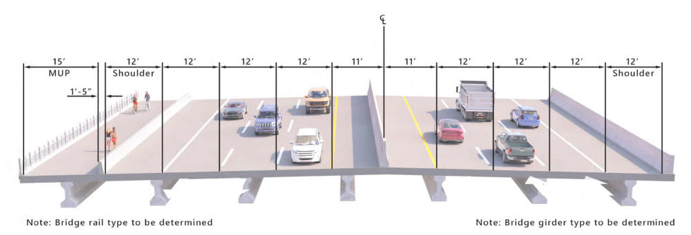
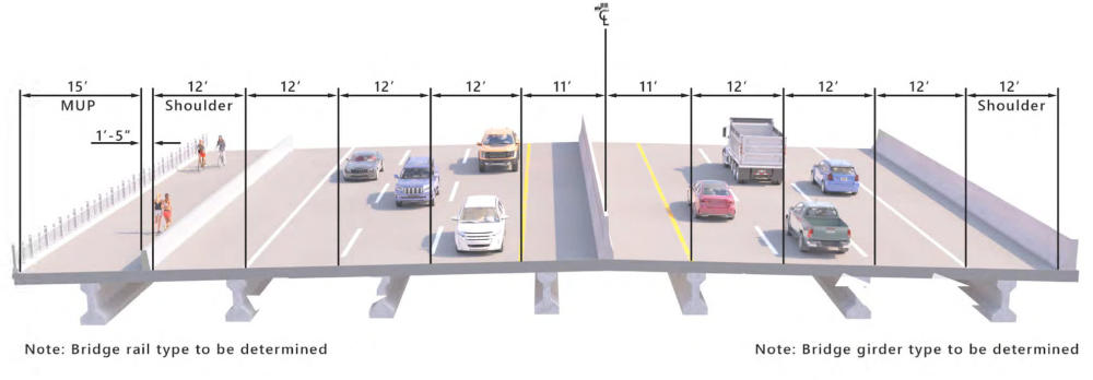
Alternate A - Bridge Typical Section
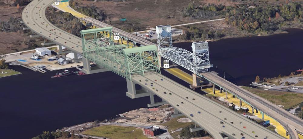
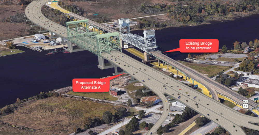
Alternate A - Visualization
(Existing Bridge, to be removed, shown beside proposed bridge in visualizations)
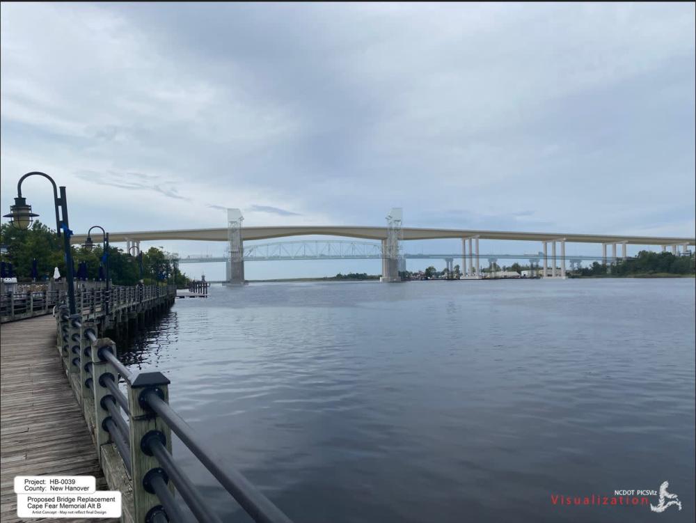
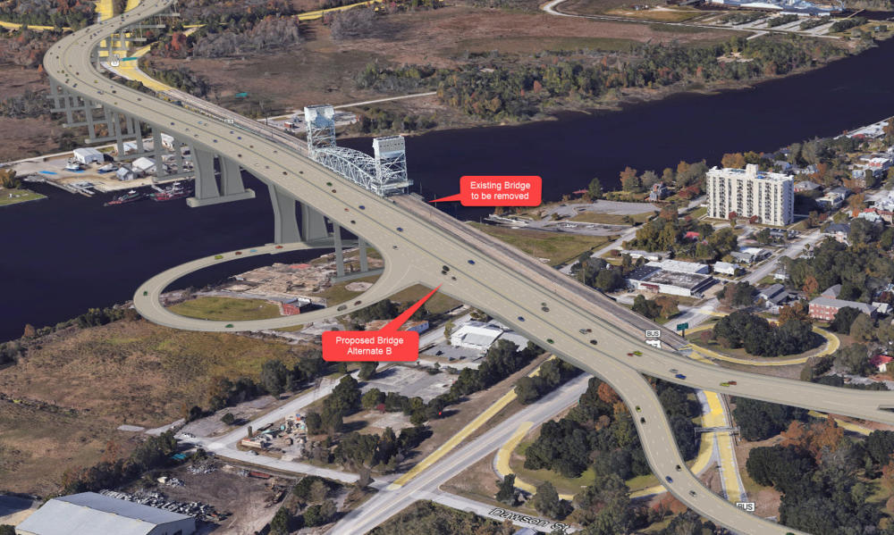
Alternate B
Fixed Structure
135-foot Vertical Clearance
Alternate B
Bridge Typical Section
Alternate B
Visualization
Existing Bridge, to be removed, shown for comparison as 'ghost' in visualization on the left.
View of existing and proposed bridges from Historic District on the right.
Project Funding:
This project is listed as Project HB-0039 in the N.C. Department of Transportation's State Transportation Improvement Program and is funded only for preliminary engineering (design, planning, environmental studies). The U.S. Department of Transportation awarded a $242 million grant to aid with funding of the replacement bridge in 2024. The total estimated project cost is $1.1 billion.
Project Timeline:
Milestone | Date* |
Alternative Selection | Fall 2025 |
| Environmental Document | TBD |
Public Hearing | TBD |
Right-of-Way Acquisition Begins | TBD |
Construction | TBD |
* Future dates are subject to change.
Next Steps
After the comment period ends, the project team will meet to review the comments received and prepare a public comment summary, which will be posted to the project website. NCDOT will meet with local government and agency partners to review public comments in conjunction with subsequent technical studies to select a preferred alternative. The alternative selection is anticipated in fall 2025.
Project Comments:
NCDOT accepts comments throughout all phases of project development.
All comments will be taken into consideration, and carry equal weight, regardless of submittal method.
Comments for consideration during the current phase of project development
were due by October 25, 2024.
The public is encouraged to leave comments using this email or phone number
or by USPS mail to the project manager listed below:
Email: CapeFearMemorialBridge@publicinput.com
Phone Number: 984-205-6615 and enter project code 10626 to leave a message
Project Manager
Mason Herndon
NCDOT Highway Division 3
5501 Barbados Boulevard
Castle Hayne, NC 28429
CapeFearMemorialBridge@publicinput.com
Title VI Feedback
To ensure we’re hearing from a broad set of voices, would you be willing to share (completely anonymously) some information about yourself?
If so, please click here https://publicinput.com/NCDOT-Title-VI-Form
Resources for Property Owners
Although the N.C. Department of Transportation works to minimize the number of homes and businesses displaced by a road
project, it is inevitable, in many cases, that a certain amount of private property is needed. The following information explains right
of way acquisition and answers questions about the process.
Right-of-Way Brochure Single Page Layout Folleto del Proceso de Adquisición de Bienes Raíces
Right-of-Way Frequently Asked Questions
Right of Way Acquisition Process Videos
Page last updated: May 13, 2026
ADA Compliance Completed