Crawford Branch Greenway Feasibility Study
Crawford Branch Greenway Feasibility Study

Welcome!
The Town of Franklin and NCDOT are seeking your input on the Proposed Crawford Branch Greenway Feasibility Study. Please take a few minutes to respond to the following questions by May 20, 2024. Thank you!
1
Study Overview
In Bike Walk Franklin: A Comprehensive Plan for Bicyclists and Pedestrians (2017), the Town identified the need for a greenway that connects the Little Tennessee River Greenway near Big Bear Park to Memorial Park on West Main Street. The vision in the plan calls for a greenway that roughly follows Crawford Branch south of Downtown Franklin.
In 2023, the Town of Franklin received a Feasibility Study Grant from NCDOT’s Integrated Mobility Division to investigate how the Crawford Branch Greenway vision may be realized. Since receiving the grant, the Town has been working to identify a route that is comfortable for people who walk and bike, has community support, and can be funded and constructed. The team working on the project has identified four alternatives that meet the goals of the project. The purpose of this survey is to learn how community members would use this future greenway.
Click HERE to learn more about feasibility studies like this one.
Project Study Area
Before we dive into the survey, let's get oriented to the project study area. Below are two sets of maps. Alternatives A and B (first two maps) illustrate different possible routes from Memorial Park to Carolina Mountain Drive. Alternatives C and D (second set of maps) show different routes from Carolina Mountain Drive to connect to the Little Tennessee River Greenway. A brief description of each alternative is below. Click on the image of each map to expand the view.
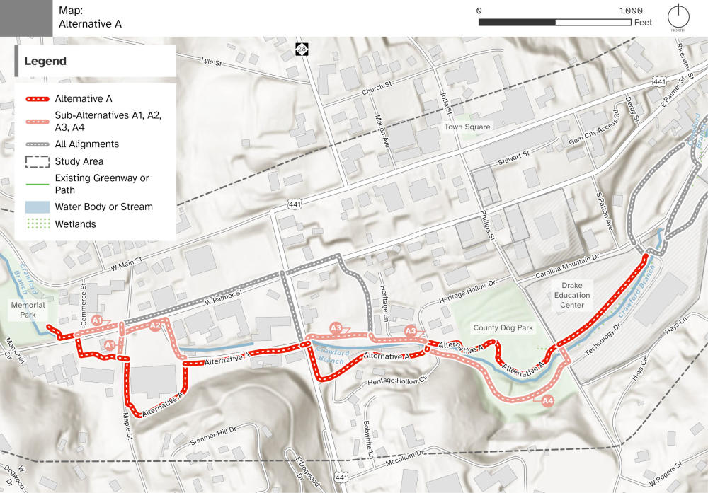
Alternative A
- From Memorial Park, it runs east to Commerce Street where it crosses West Palmer Street.
- Runs east to Maple Street through property owned by the Town (in front of the fire department).
- Continues through the Ingles property along Palmer Street Circle to Porter Street where parking would need to be redesigned to provide a trail and improved parking / traffic patterns.
- After crossing Porter Street, the trail would transition to a shared street through Heritage Hollow (sharing travel lanes with low-speed traffic).
- A new pedestrian bridge (to replace the former Heritage Hollow vehicle bridge) would cross Crawford Branch from the south side to the north side.
- Connects to the Macon County Dog Park along an existing sewer easement.
- Crosses Phillips Street and runs through the Drake Enterprises campus along the alignment of the existing sidewalk that would be widened to a minimum 10-foot-wide multi-use path.
Exact alignments will need to be negotiated based on the willingness of private property owners to provide a trail easement through many commercial properties. As such, various sub-alternatives were developed to provide options for investigation with property owners. The following sub-alternatives illustrate other ways to connect through commercial properties with the same goal in mind, to stay close to Crawford Branch.
- A1 would remain along W. Palmer Street before crossing the road at Maple Street.
- A2 would follow in front of the Ingles parking lot instead of behind the building.
- A3 would follow the north side of Crawford Branch instead of the south side.
- A4 would stay on the south side of Crawford Branch on county-owned property before entering onto the Drake campus.
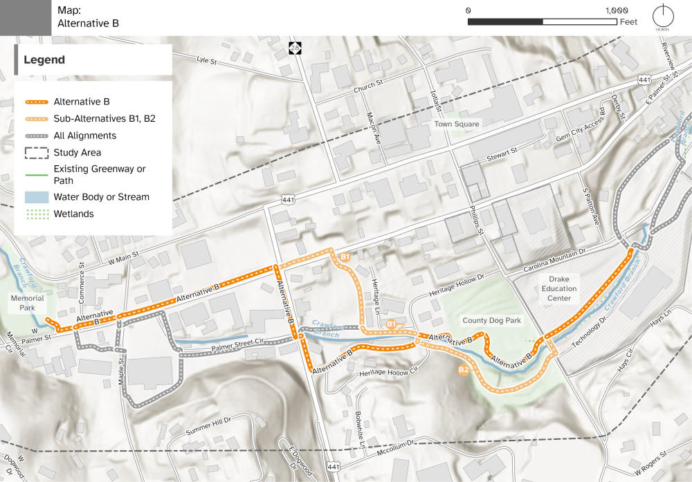
Alternative B
- From Memorial Park, it runs east to Porter Street as a multiuse side path along West Palmer Street. There are many impacted driveways and parking lots that would need to be redesigned to provide a trail and improved parking / traffic patterns.
- At Porter Street, turns south and runs along the west side of Porter Street, crossing to the east side near Palmer Street Circle and continuing through Heritage Hollow as a shared street (sharing travel lanes with low-speed traffic).
- A new pedestrian bridge (to replace the former Heritage Hollow vehicle bridge) would cross Crawford Branch from the south side to the north side.
- Connects to the Macon County Dog Park along an existing sewer easement.
- Crosses Phillips Street and runs through the Drake Enterprises campus along the alignment of the existing sidewalk that would be widened to a minimum 10-foot-wide multi-use path.
Exact alignments will need to be negotiated based on the willingness of private property owners to provide a trail easement through many commercial properties. As such, various sub-alternatives were developed to provide options for investigation with property owners. The following sub-alternatives illustrate other ways to connect through commercial properties with the same goal in mind.
- B1 would remain along W. Palmer Street before crossing the road west of Heritage Lane and onto private property to the north side of Crawford Branch.
- B2 would follow Crawford Branch on the south side on county-owned property until entering the Drake Enterprises campus.
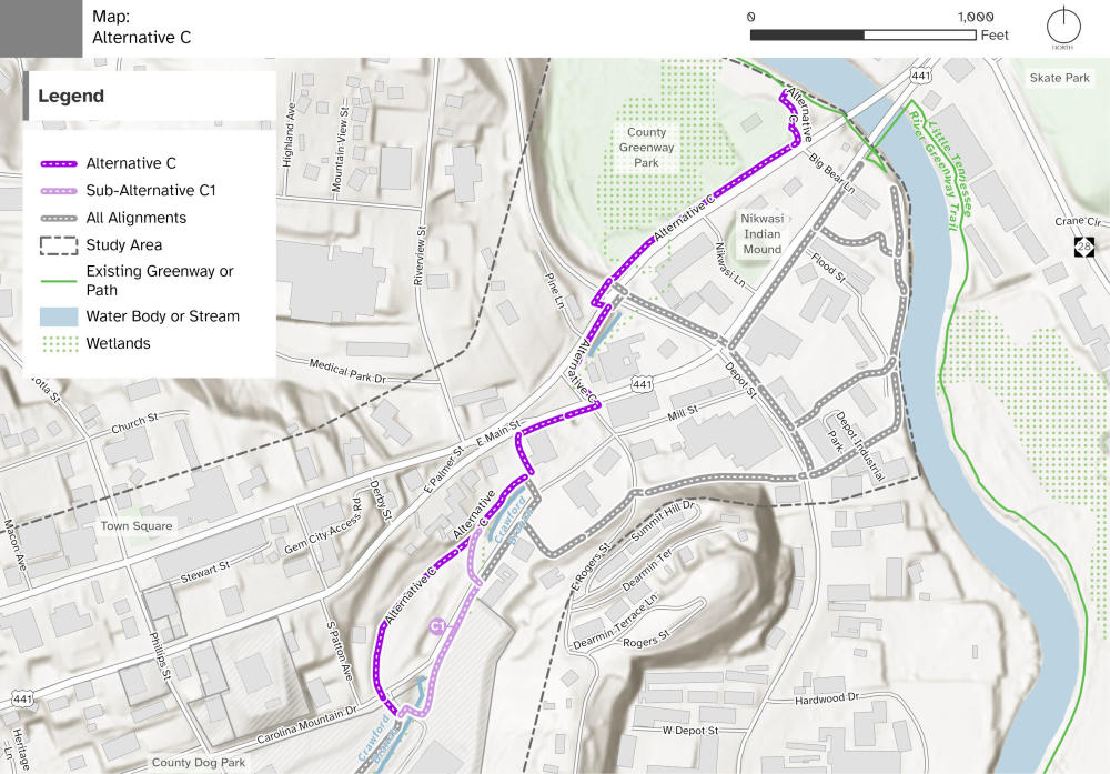
Alternative C
- From the Drake campus, crosses to the north side of Carolina Mountain Drive and then runs along the base of a hill on undeveloped properties.
- Connects to the United Community Credit Union on a sewer easement along the north side of Crawford Branch. The bank parking lot would need to be reconfigured for a trail connection.
- Runs along East Main Street where the sidewalk would be widened to provide a 10-foot-wide multi-use sidepath to East Rogers Street.
- Crosses US 441 and heads north up East Rogers Street.
- Turns to the east to continue as a sidepath on the south side of NE Main Street to Depot Street.
- At Depot Street, crosses to the north side of NE Main Street and continues as a sidepath with a boardwalk before connecting to Big Bear Park and the Little Tennessee River Greenway.
Exact alignments will need to be negotiated based on the willingness of private property owners to provide a trail easement through many commercial properties. As such, one sub-alternative was developed to provide options for investigation with property owners.
- C1 would stay on Drake Enterprises campus on the southeast side of Carolina Mountain Drive before crossing the street to follow the north side of Crawford Branch.
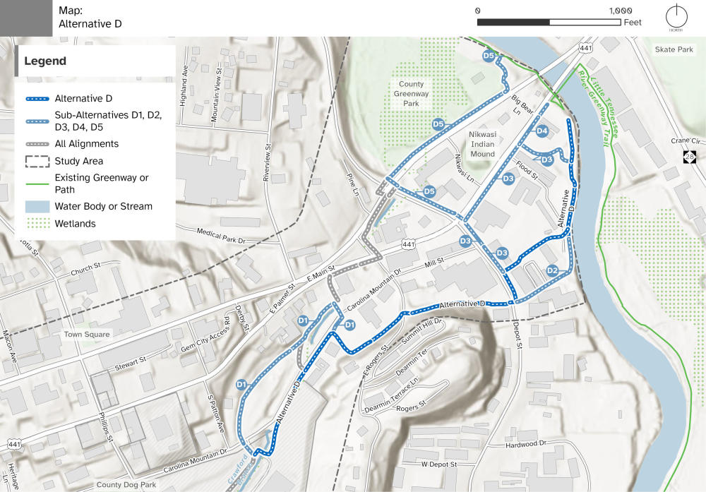
Alternative D
- From the Drake campus, continues on the south side of Crawford Branch and Carolina Mountain Drive as a multi-use sidepath that will require parking lot modifications.
- Runs south between several commercial properties then turns east to connect to East Rogers Street and Depot Street.
- Crosses Depot Street then runs north along Depot Street for a short segment.
- Turns to the west to run between commercial properties to reach the edge of the Little Tennessee River.
- Follows the river and connects to the existing Little Tennessee River Greenway.
Exact alignments will need to be negotiated based on the willingness of private property owners to provide a trail easement through many commercial properties. As such, various sub-alternatives were developed to provide options for investigation with property owners. The following sub-alternatives illustrate other ways to connect through commercial properties with the same goal in mind.
- D1 would run along undeveloped property on Carolina Mountain Drive as a greenway.
- D2 would run through the Depot Industrial Park to connect to the river. This would require site modifications.
- D3 would continue up Depot Street and then run east on the south side of East Main Street as a sidepath until connecting to the existing greenway through the land owned by Main Spring.
- D4 would stay along East Main Street to the Women’s History Park and connect with the existing greenway and bridge over the Little Tennessee River.
- D5 would continue north on Depot Street to cross East Main Street and NE Main and continue as a sidepath with a boardwalk along the street to Big Bear Park.