
Skip Navigation

Project Pipeline Monticello Avenue/St. Paul's Boulevard Study (HR-23-06)

Project Pipeline Monticello Avenue/St. Paul's Boulevard Study (HR-23-06)

 Project Pipeline is a performance-based planning program to identify cost-effective solutions to multimodal transportation needs in Virginia. Through this planning process, projects and solutions may be considered for funding through programs, including SMART SCALE, revenue sharing, interstate funding and others.

The purpose of this study is to analyze the operational and safety issues identified on the Monticello Avenue/St. Paul's Boulevard corridor from East Charlotte Street/Wood Street to Church Street, with a focus on providing enhanced pedestrian, bicycle, and transit access, as well as congestion mitigation and safety improvements. From 2018 to 2022, there were 392 crashes along the corridor; 69 percent were angle crashes, and 16 percent were rear-end crashes. In the same time period, there were seven crashes involving pedestrians with two pedestrian fatalities and three total fatalities. Improving safety for all road users is a focus of this study. Congestion mitigation is also needed, particularly at the southern end of the corridor related to the I-264 ramps and at the northern end in the vicinity of 26th Street and 27th Street. The objective of this study is to identify cost-effective preferred improvement alternatives that address the deficient conditions and prioritize safety for vulnerable users.
 

Survey

Visit the study webpage.

Study Partners

City of Norfolk

Hampton Roads Transportation Planning Organization (HRTPO)

Kimley-Horn

Study Location
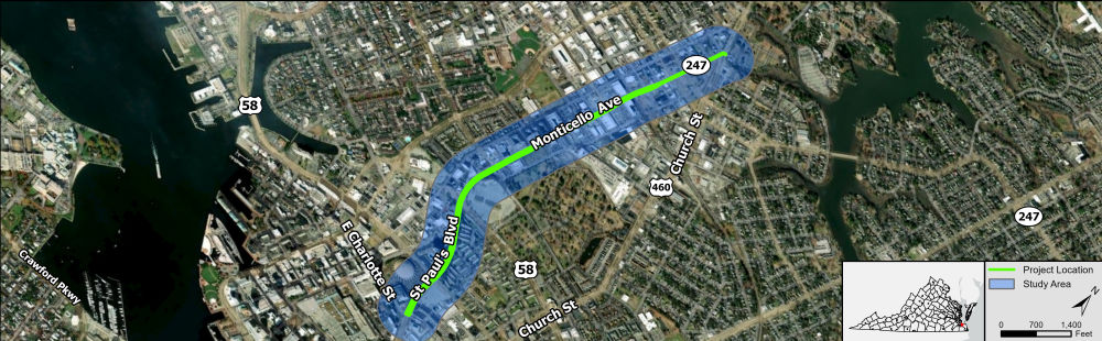
Study area map for Project Pipeline Study HR-23-06 depicting the Monticello Avenue/St. Paul's Boulevard corridor from East Charlotte Street to Church Street within the City of Norfolk


The following needs have been identified for this study. Do you agree with this initial assessment? (Check all that apply)

Safety improvements
Congestion mitigation
Pedestrian safety improvements
Enhanced pedestrian access
Enhanced bicycle access
Enhanced transit access
Transportation demand management
Closed to responses

Are there other issues along the study corridor (not identified above) that you think should be addressed?

Closed for Comments

Rank what is the most important issue to you along the study corridor.

Drag your top items in order of importance.

Closed to responses

Which of the following safety issues concern you? (Check all that apply)

Lack of ADA ramps and accessibility
Speeding / aggressive driving
Inadequate pavement marking and signage
Insufficient / missing crosswalks and pedestrian signal timing
Inadequate lighting
Lack of sidewalks / missing sidewalks
Inadequate bicycle facilities
Sudden stopping / rear-end crashes
Side-impact crashes
Closely spaced driveways
Difficulty weaving / merging
Inadequate transit / bus stops
Running red lights
Other
Closed to responses

Do you experience congestion when traveling along the study area? If so, when? (Check all that apply)

Weekday morning rush (6-9 a.m.)
Weekday mid-day (9 a.m. to 3 p.m.)
Weekday afternoon rush (3-6 p.m.)
Weekday evening/overnight (6 p.m. to 6 a.m.)
Weekends
Never
Closed to responses

What mobility issues do you typically experience when using the study area? (Check all that apply)

Difficulty when walking
Difficulty making left turns
Difficulty accessing businesses
Difficulty when riding a bicycle
Lack of turn lanes
Vehicles blocking entrances
Poor signal coordination
Other
Closed to responses

When do you typically experience mobility issues in the study area? (Check all that apply)

Weekday morning rush (6-9 a.m.)
Weekday mid-day (9 a.m. to 3 p.m.)
Weekday afternoon rush (3-6 p.m.)
Weekday evening/overnight (6 p.m. to 6 a.m.)
Weekends
Never
Closed to responses

When do you typically travel in the study area? (Check all that apply)

Weekday morning rush (6-9 a.m.)
Weekday mid-day (9 a.m. to 3 p.m.)
Weekday afternoon rush (3-6 p.m.)
Weekday evening/overnight (6 p.m. to 6 a.m.)
Weekends
Never
Closed to responses

How often do you travel along the study area?

Daily
A few times per week
A few times per month
A few times per year
Less than once a year
Closed to responses

Why do you travel along the study corridor? (Check all that apply)

Home
Work
School
Shopping / Errands
Dining / Entertainment
Passing through
Other
Closed to responses

What mode(s) of travel do you use when traveling along the study area? (Check all that apply)

Personal vehicle
Taxi / Uber / Lyft
Carpool / Vanpool
Metro bus, local bus, or commuter bus
Truck or commercial vehicle
Walking
Cycling
Other
Closed to responses

What multimodal facilities are needed along this study area? (Check all that apply)

Crosswalks / pedestrian signals
Shared-use path
Sidewalks
Bicycle lanes
Transit service bus shelters
Park & ride lot
Bus transfer station
Other
Closed to responses

Please drop a pin within the study area and share your concerns.
