Lower Frew Levee Setback Project
Lower Frew Levee Setback Project
Thank you for visiting our Virtual Open House. We invite you to learn more about the project and what we are doing to reduce flood and erosion risks and improve habitat in and along the lower Tolt River.
To view the Online Open House in a language other than English, click on Translate at the top of the page. Additional interpretation and translation services are available to you, at no cost. If you need them, please contact us at sarah.mccarthy@kingcounty.gov or 206-477-4766.
Welcome
Welcome to the Lower Frew Levee Setback Project Virtual Open House.
King County, as a service provider to the King County Flood Control District, is working to reduce flood risks and improve fish habitat along the lower Tolt River.
The purpose of this Virtual Open House is to:
- To share information about the project, the selected alternative, and the other options considered.
- To hear your thoughts about how the Lower Frew Levee Setback Project can be most valuable to you and your community.
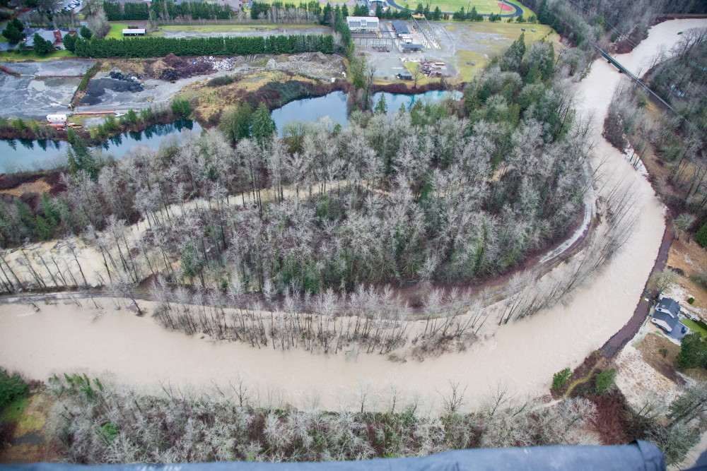
Photo taken during the January 2015 flood event. Shows the Tolt River at 8,000 cubic feet per second (cfs), Lower Frew Levee project area, and the City of Carnation.
Thank you for your participation!
We welcome your questions and comments. Your feedback will help inform the project design. We are committed to keeping you informed on project updates and will let you know about future opportunities to provide additional feedback. To sign up for project updates, visit our website at kingcounty.gov/LowerFrew.
Questions?
Contact Sarah McCarthy, Project Manager, at sarah.mccarthy@kingcounty.gov or 206-477-4766.
How does this Virtual Open House work?
- Visit each page to learn more about different aspects of this project. You can also click Continue at the bottom to go to the next page.
- Provide your ideas on how this project can be most valuable to you through are survey questions on the Share Your Feedback page. Responses to public comments and questions will be posted on this online open house within 5-7 business days. Responses to private comments and questions will be responded to if an email address or phone number is provided.
All comments are considered public record. However, if you turn off the ‘Post Publicly’ button next to the comment box or survey question, your comments will not be visible to others.
Please join us and learn how King County, as a service provider to the King County Flood Control District, is working on a project that will reduce flood and erosion risks and improve habitat in and along the lower Tolt River. King County plans to remove the existing Lower Frew Levee and construct a new levee set further back from the river. The recreational Tolt River trail will be rebuilt on top of the new setback levee.
Key Terms
- Alternatives: Different project design options to achieve the project purpose, need, and objectives.
- Cubic feet per second (cfs): The rate of water movement in a river or stream representing a volume of one cubic foot passing a given point in one second.
- Culvert: A structure that channels water past an obstacle, such as a roadway or railroad prism.
- Fish habitat: The aquatic environment and adjacent upland area critical for fish to live, breed, and grow during various life stages.
- Floodplain: The relatively flat lands adjacent to a river, formed mainly of river sediments, that become inundated during periods of high flow, or flood.
- Floodplain reconnection: Reconnecting rivers to their floodplain by removing structures such as levees, improves the natural function and ecology of rivers.
- Large wood migration protection: Engineered structures created in rivers and floodplains designed to simulate naturally occurring log jams. Log jams help direct river flow and create forage and refuge habitat for salmon.
- Levee: A raised structure designed and constructed to contain, control, or divert the flow of water to provide protection from temporary flooding.
- One percent annual chance flood: A flood that has a one percent chance of occurring or being exceeded in any given year. This is also known as the 100-year flood.
- River side channel: A smaller channel next to the Tolt River main channel to provide off-channel habitat.