BP1-R032: Replace bridge on N.C. 615 over Corey's Ditch in Currituck County
BP1-R032: Replace bridge on N.C. 615 over Corey's Ditch in Currituck County
NCDOT proposes two alternatives for replacing the bridge on N.C. 615 over Corey's Ditch in Currituck County.
Interactive Study Area Map:
Open House Public Meeting
_____________________________________________
December 9, 2024
Knotts Island Elementary School
413 Woodleigh Road, Knotts Island
5:00 pm to 7:00 pm
No formal presentation was made
_____________________________________________
Project Overview
The N.C. Department of Transportation proposes two alternatives for the bridge on N.C. 615 (Marsh Causeway) over Corey's Ditch near Knott’s Island in Currituck County. The existing 180-foot bridge will be either replaced in place or the man-made canal will be closed and paved over with new roadway. Traffic will be maintained with a temporary on-site detour utilizing two-way, one lane traffic with a temporary signal.
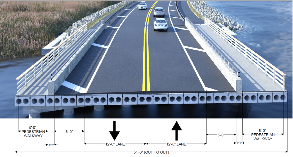
N.C. 615 is a rural minor collector with two 12-foot travel lanes and 6-foot shoulders, with an 8-foot barrier separated walkway to the north and a 5-foot barrier separated walkway to the south. The existing bridge, built in 2007 carrying N.C. 615 over Corey's Ditch had near unstable foundations due to the following Tropical Storms Dorian and Isaias. An interim repair was performed, but a long-term solution is being sought by NCDOT as the channel continues to expand into the marsh.
The two current alternatives are (1) A bridge replacement, and (2) a closure of the canal.
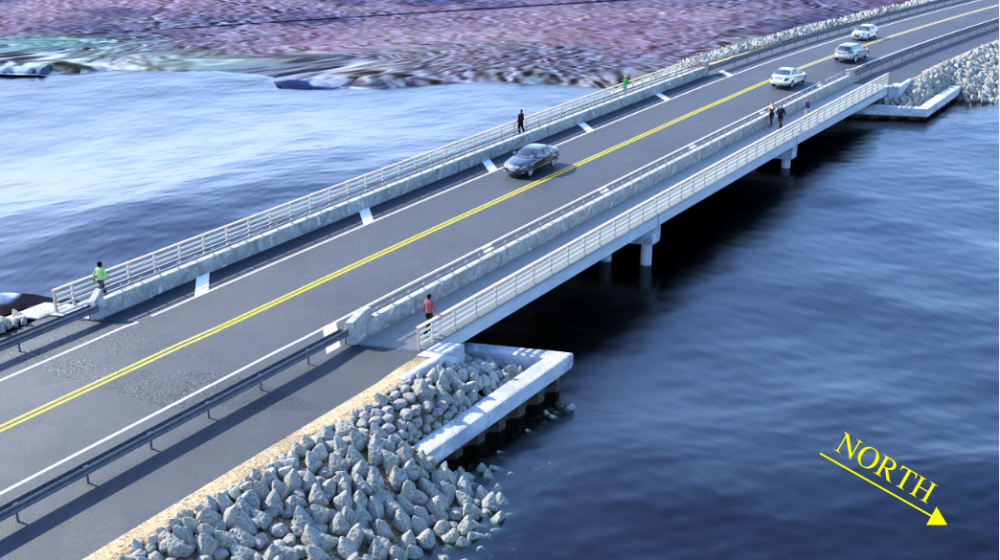
- Alternative 1 - consists of replacing the bridge in kind with deeper foundations. The proposed bridge replacement would be 215-feet long and match the existing bridge in lanes and pedestrian walkways (2 lanes at 12-feet, shoulders at 6-feet, 8-foot and 5-foot wide barrier separated pedestrian walkways for a total bridge width of 54-feet)
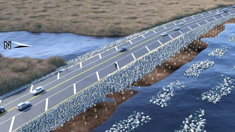
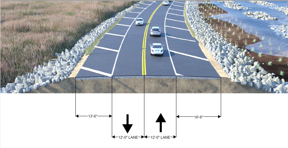
- Alternative 2 - consists of closing Corey’s Ditch at the current bridge location using a combination of large riprap, walls and hardening. The typical section across the structure will match Alternate 1. Additionally, to the north of the bridge, rock fortification will be installed to protect from tidal flows.
Project Rendering and Typical Sections
Alternative 1: Bridge Replaced
To view or download project map click here or on the Alternative 1 rendering of bridge on N.C. 615 (Marsh Causeway) over Corey's Ditch below
Alternative 1 bridge typical section
Alternative 2: Bridge Removed
To view or download project map click here or on the Alternative 2 rendering of N.C. 615 without bridge over Corey's Ditch below
Alternative 2 N.C. 615 typical section
Project Funding:
Activity | Alt 1 Costs* | Alt 2 Costs* |
Project Development & Design | $ 0.25 M | $ 0.25 M |
Construction | $ 15.2 M | $ 16.2 M |
Total Cost | $ 15.45 M | $ 16.2 M |
*Costs are subject to change (M=Million)
Project Timeline:
Activity | Date* |
Public Meeting | December 9, 2024 |
Environmental document | TBD |
Construction Begins | Winter 2027 |
*Future dates subject to change
Project Comments:
NCDOT accepts comments throughout all phases of project development.
All comments will be taken into consideration, and carry equal weight, regardless of submittal method.
Comments for consideration during the current phase of project development
were to be submitted before December 30, 2024
The public is encouraged to leave comments using this webpage, email, or phone number:
Email: nc615-currituck@publicinput.com
Phone Number: 984-205-6615 and enter project code 7208 to leave a message
Project Contact Information
John Abel
Division Project Team Lead
NCDOT Division Highway 1
113 Airport Drive, Suite 100
Edenton, NC 27932
Project Contact Information
Sam Cullum, PE
Consultant Project Manager
Kisinger Campo & Associates
301 Fayetteville Street, Suite 1500
Raleigh, NC 27601
Title VI Feedback
To ensure we’re hearing from a broad set of voices, would you be willing to share (completely anonymously) some information about yourself?
If so, please click here: https://publicinput.com/NCDOT-Title-VI-Form
RESOURCES FOR PROPERTY OWNERS
Although the N.C. Department of Transportation works to minimize the number of homes and businesses displaced by a road
project, it is inevitable, in many cases, that a certain amount of private property is needed. The following information explains right
of way acquisition and answers questions about the process.
Right-of-Way Brochure Single Page Layout Folleto del Proceso de Adquisición de Bienes Raíces
Right-of-Way Frequently Asked Questions
Right of Way Acquisition Process Videos


