 Eisenhower Avenue Study Alternatives - City of Alexandria (NV-23-07)
Eisenhower Avenue Study Alternatives - City of Alexandria (NV-23-07)
Welcome to the Eisenhower Avenue Project Pipeline Study Survey
Please provide feedback on project ideas to improve bicycle and pedestrian access, safety, and mobility on Eisenhower Avenue. Your feedback will help your local leaders determine whether to pursue future funding opportunities.
Introduction
Visit the Project Pipeline study webpage.

Project Pipeline is a performance-based planning program to identify cost-effective solutions to multimodal transportation needs in Virginia. Through this planning process, projects and solutions may be considered for funding through programs, including SMART SCALE, Revenue Sharing, Interstate funding and others.
Study Partners
- City of Alexandria
- ATCS, PLC
Study Background
Virginia and the City of Alexandria have identified the Eisenhower Avenue corridor as having a high need for pedestrian and vehicle safety and accessibility by non-vehicular modes. Virginia's Transportation Plan, or VTrans, identifies and prioritizes statewide transportation needs for the next 10 years. The City has identified this road in its Vision Zero program as well.
The focus of this study is to assess key areas of Eisenhower Avenue and identify potential improvements for bicycle and pedestrian access, transit access, transportation demand management, congestion mitigation, and safety.
We encourage you to view the City of Alexandria's Eisenhower Avenue Transportation Study webpage for more information or watch the recorded presentation before taking the survey and providing your feedback.
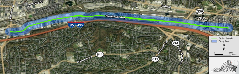
Study Location
The Eisenhower Avenue study corridor covers the area from Van Dorn Street (VA Route 401) to Holland Lane and is entirely located in the City of Alexandria. The roadway runs parallel to I-495 (to the south) and Duke Street (to the north). Eisenhower Avenue is classified as a minor arterial road. The entire study corridor is 4.4 miles long. The posted speed limit for Eisenhower Avenue is 35 MPH west of Mill Road, and 25 MPH east of Mill Road.