Swannanoa River Greenway Extension Feasibility Study
Swannanoa River Greenway Extension Feasibility Study
Welcome!
The City of Asheville, French Broad River Metropolitan Planning Organization (MPO), and NCDOT are seeking your input on the proposed Swannanoa River Greenway Extension Feasibility Study. Please take a few minutes to respond to the following questions by April 30, 2024. Thank you!
Study Overview
Originally conceived in the Wilma Dykeman Riverway Plan, the Swannanoa River Greenway (SRG) will eventually extend from the confluence of the French Broad River and the Swannanoa River near the Amboy Road / Meadow Road intersection east to the Asheville city limits near the Azalea Road and Tunnel Road South intersection. Large sections of the SRG will be constructed through two North Carolina Department of Transporation (NCDOT) projects, the Amboy Road/Meadow Road widening project and the Swannanoa River Road (NC 81) widening project. Once these two projects are constructed, there will be a gap; the goal of this feasibility study is to identify options to connect the two projects.
With that in mind, the French Broad River MPO applied for and received a Feasibility Study Grant from NCDOT’s Integrated Mobility Division. Since receiving the grant in 2023, the City and MPO have been working to identify a route that is comfortable for people who walk and bike, has community support, and can be funded and constructed. The team working on the project has identified three alternatives that meet the goals of the project. The purpose of this survey is to learn how community members would use this future greenway.
Click HERE to learn more about feasibility studies like this one.
Project Study Area
Before we dive into the survey, let's get oriented to the project study area. The following maps illustrate the project study area and three possible options for this greenway connection. No alternative has been decided yet. A brief description of each alternative is below. Click on the image of each map to expand the view.
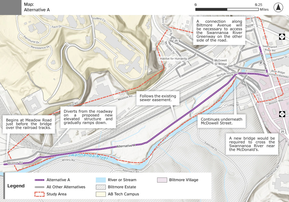
Alternative A
This alternative would follow the Swannanoa River to the greatest extent possible. A paved path would begin at Meadow Road just before the bridge over the railroad tracks. From the western elevated edge of the bridge, the trail would divert from the roadway on a proposed new elevated structure and slowly ramp down to run along an existing sewer easement on the northside of the river between the railroad tracks and the river. On the eastern end of this alternative, a new bridge would be required to cross the Swannanoa River near the McDonald’s restaurant, running parallel and south of the railroad bridges over the river. A connection along Biltmore Avenue will be necessary to access the Swannanoa River Greenway alignment on the east side of the road that is advancing as a separate project. Given that there are extensive engineering and permitting challenges with this alternative, further engineering investigation is needed to determine feasibility and cost. This alternative would also require approval from several entities including Norfolk Southern, Duke Energy, Metropolitan Sewerage District (MSD), and the Biltmore Estate.
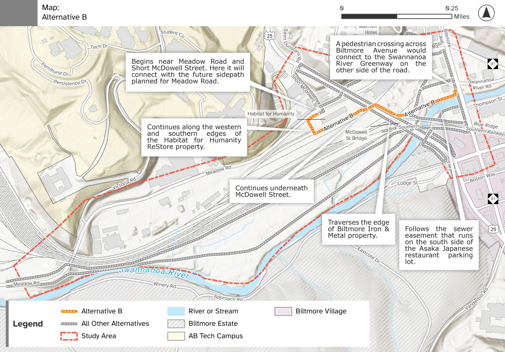
Alternative B
This alternative starts near Meadow Road and Short McDowell Street. Here it will connect with the future sidepath planned for Meadow Road that is planned to be constructed as with NCDOT’s Meadow Road Project. From this intersection, the alternative would continue south as a paved path along the western and southern edges of the Habitat for Humanity ReStore property. After passing under the McDowell Street bridge on an abandoned rail bed, the path would traverse the edge of Biltmore Iron & Metal property and follow the sewer easement that runs on the south side of the Asaka Japanese restaurant parking lot. A pedestrian crossing across Biltmore Avenue would connect with the future Swannanoa River Greenway to the east.
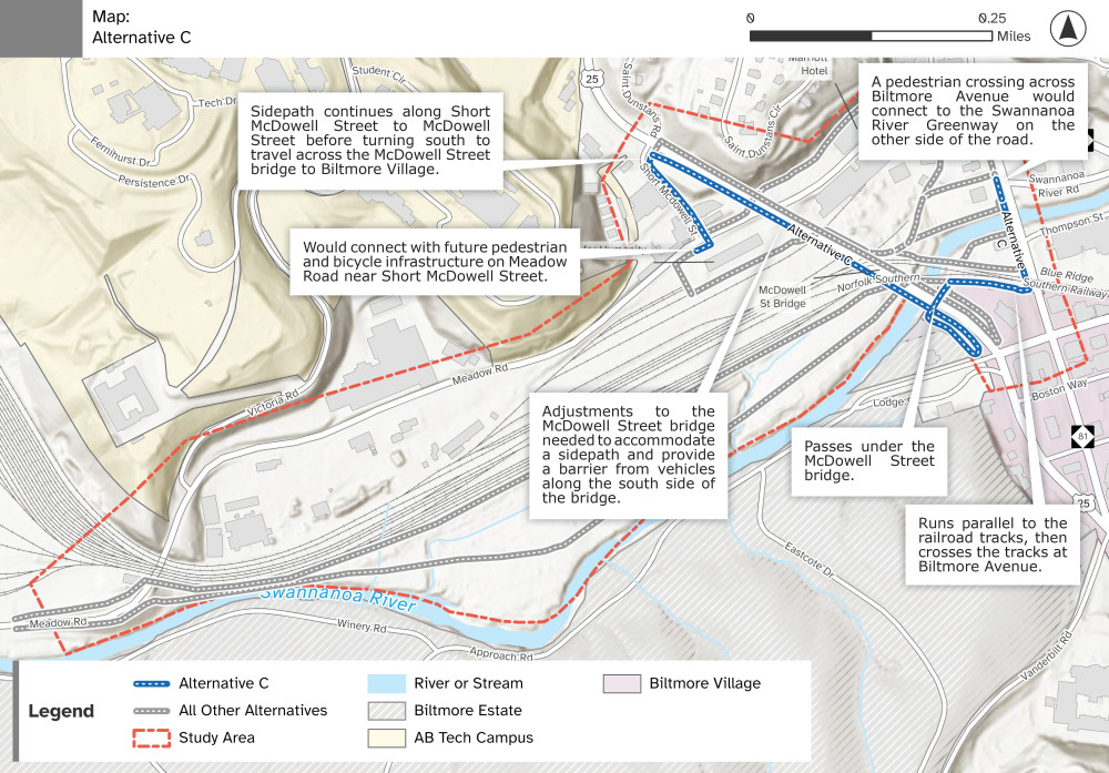
Alternative C
This alternative starts near Meadow Road and Short McDowell Street. Here it will connect with the future sidepath planned for Meadow Road. From this intersection, the alternative will continue north along Short McDowell Street to McDowell Street before turning south to travel across the bridge to Biltmore Village. Adjustments to McDowell Street bridge would be made to accommodate a sidepath and to provide a barrier from vehicles along the south side of the bridge. The route would then follow the edge of the Biltmore property and pass under the McDowell Street bridge into the Mcdonald's parking lot. From there it will run parallel with the railroad tracks and then turn north to cross the tracks at Biltmore Avenue. A pedestrian crossing at Biltmore Avenue would connect with the future Swannanoa River Greenway to the east.
Swannanoa River Greenway: A Greenway Spine
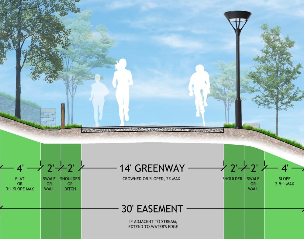
The Swannanoa River Greenway is a Greenway Spine, which the City of Asheville defines as being, "a major thoroughfare of the City’s pedestrian/bicycle system. This greenway type carries the highest level of service (carrying capacity, or number of people) and design speed (how quickly a user can travel). It also has the greatest level of investment due to its prominence within the system. It has the greatest width (average 12-14’ or more narrow if a parallel bicycle facility can be established), amenity investment, and name recognition. Greenway Spines travel through entire districts of the City, serving as the 'highway' of greenways." -- Close the GAP