 P-5718 N.E. Maynard Road Grade Separation - Cary
P-5718 N.E. Maynard Road Grade Separation - Cary
Proposed grade separation of the North Carolina Railroad (NCRR) / Norfolk Southern (NS) H-Line and the CSX S-line to replace Maynard Road at-grade crossing in Cary.
Study Area Map:

Project Overview
The N.C. Department of Transportation proposes to construct a grade separation of the North Carolina Railroad (NCRR), Norfolk Southern (NS) H-line, and the CSX S-line to replace the N.E. Maynard Road at-grade crossing in Cary. This rail line provides both freight and passenger service to the east and west of Cary.
The purpose of this project is to eliminate rail-highway conflicts at the existing at-grade railroad crossing location on N.E. Maynard Road near its intersection with E. Chatham Street. The proposed project will improve vehicular mobility and safety at this location and the surrounding area.
Project Highlights
The Build Alternative will grade separate N.E. Maynard Road under the NCRR, NS and CSX rail lines and realign the Chatham Street and N.E. Maynard Road intersection south of its existing alignment, outside of the railroad corridor. This alternative was selected because it:
- Minimizes impacts to the human, natural, and physical environment;
- Reduces right-of-way and utility costs;
- Results in fewer overall community impacts (relocations);
- Received overwhelming community support compared to Design Concept 2 (based on public input, 63 noted support for Design Concept 1 and four noted support for Design Concept 2); and
- Results in fewer residential relocations than design concept 2.
Typical Roadway Sections of the Recommended Alternative
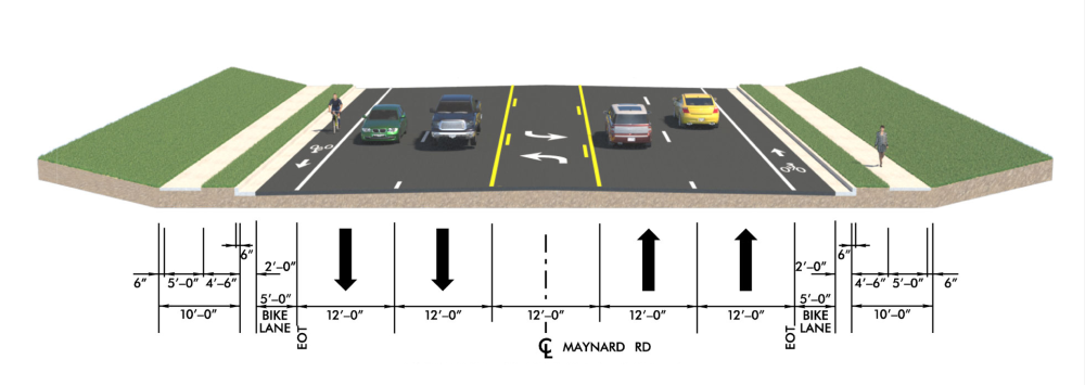
N.E. Maynard Road includes:
- Two 12-foot travel lanes in each direction
- A two-way center left-turn lane
- Curb and gutter along outside travel lanes
- Sidewalks and bike lanes on each side of the roadway
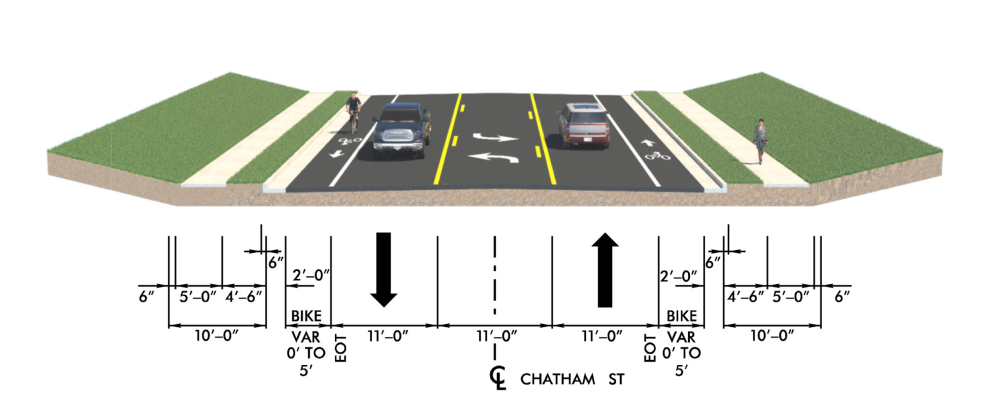
E. Chatham Street includes:
- One 11-foot travel lane in each direction
- A two-way center left-turn lane
- Curb and gutter along outside travel lanes
- Sidewalks and bike lanes on each side of the roadway
Project History
The proposed project is part of the NCDOT’s Sealed Corridor Program. This Program works to eliminate or improve rail and vehicular crossings in communities along the Raleigh-Charlotte Rail Corridor in North Carolina, including communities between Raleigh, Greensboro, and Charlotte.
The proposed project was put on hold due to funding constraints in May 2020 and restarted in June 2023. The project is currently funded for Right of Way and Construction.
Public Involvement
October 2018
- Public outreach was conducted at Mobile Estates and Chatham Estates. The outreach consisted of going door-to-door in both communities to invite residents to attend the public meeting, distributing handouts with relevant project information, and answering questions from residents.
- A Local Business Owner Meeting was held to provide information about the proposed project to owners in the project area; thirteen business owners attended the meeting.
- An in-person Public Meeting was held. Approximately 71 members of the public registered their attendance, and 101 comments were received at the meeting or during the comment period following the meeting. Concerns centered around right-of-way, purpose and need, public involvement, and environmental justice impacts.
January 2019 and June 2019
- NCDOT presented the project at small group meetings held by the N.C. Latino Congress. Approximately 120 members of the community attended the June meeting, and 71 comments were received at that same meeting.
October 2026
A Public Meeting will be held on October 6 from 4:00 PM to 7:00 PM at the First United Methodist Church on 117 S. Academy Street in downtown Cary. The meeting will present the latest information on the project.
NCDOT has endorsed Design Concept 1 as the recommended alternative based upon the findings from the environmental analysis process.
Design Concept 1:
Grade separate N.E. Maynard Road under the NCRR/NS and CSX rail lines and realign the Chatham Street/N.E. Maynard Road intersection south of its existing alignment, outside of the railroad corridor.
- Minimizes impacts to the human, natural, and physical environment
- Reduces right-of-way and utility costs
- Results in fewer overall community impacts (relocations)
- Received overwhelming community support compared to Design Concept 2 (based on public input, 63 noted support for Design Concept 1 and four noted support for Design Concept 2)
Results in fewer residential relocations than design concept 2.
Project Map Recommended Alternative Design Concept 1
Grade separate N.E. Maynard Road under the NCRR, NS and CSX rail lines and realign the Chatham Street and N.E. Maynard Road intersection south of its existing alignment, outside of the railroad corridor.Grade separate N.E. Maynard Road under the NCRR, NS and CSX rail lines and realign the Chatham Street and N.E. Maynard Road intersection south of its existing alignment, outside of the railroad corridor.
(click below to enlarge)

Do you have questions/comments regarding the temporary closure of N. E. Maynard Road segment that currently crosses the railroad?
Do you have questions/comments regarding the realignment of E. Chatham Street, or reconfiguration of driveway accesses along N.E. Maynard Road or E. Chatham Street?
Detour Map

Do you have questions or comments regarding the proposed detour route?
Design Concept 2
Grade separate N.E. Maynard Road over Chatham Street and the NCRR, NS and CSX rail lines, on new alignment east of existing N.E. Maynard Road.

Typical Sections
N.E. Maynard Road includes:
- Two 12-foot travel lanes in each direction
- A two-way center left-turn lane
- Curb and gutter along outside travel lanes
- Sidewalks and bike lanes on each side of the roadway
Typical Sections
E. Chatham Street includes:
- One 11-foot travel lane in each direction
- A two-way center left-turn lane
- Curb and gutter along outside travel lanes
- Sidewalks and bike lanes on each side of the roadway
Comparison of Environmental lmpacts between Design Concepts 1 and 2
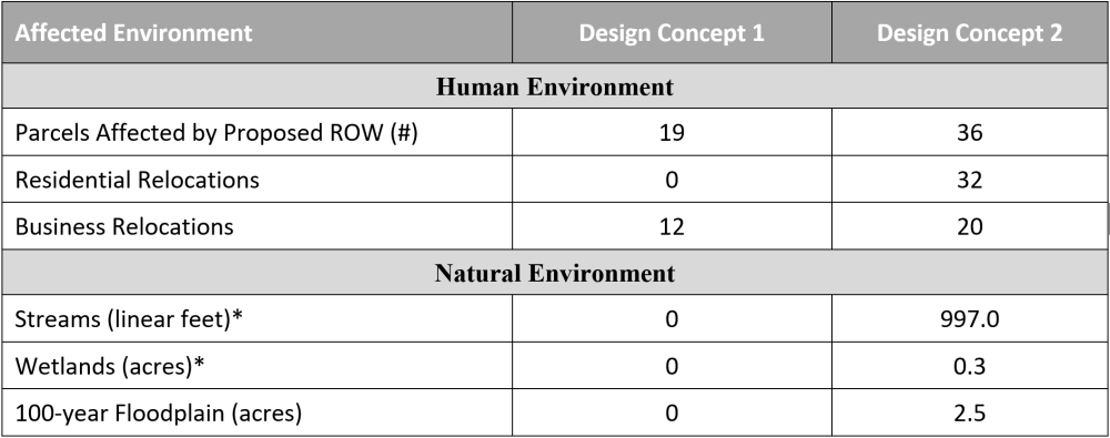
*Denotes the impacts were calculated using construction limits plus 25 feet
Renderings


Project Funding:
Activity | Estimated Costs* |
| Property Acquisition | $ 37.3 Million |
Construction and Utilities Costs | $ 46.5 Million |
Total Cost | $ 83.8 Million |
*Costs are subject to change. Based on currently adopted NCDOT State Transportation Improvement Program.
Project Timeline:
Milestones | Date |
Right of Way | Summer 2027 |
Construction Begins | Spring 2032 |
*Project timeline is subject to change. Based on currently adopted NCDOT State Transportation Improvement Program.
Project Comments
NCDOT accepts comments throughout all phases of project development.
All comments will be taken into consideration, and carry equal weight, regardless of submittal method.
To submit comments for consideration during the current phase of project development,
please submit before October 27, 2026.
The public is encouraged to leave comments using this webpage, email, or phone number:
Email: MaynardRoad-GradeSeparation@publicinput.com
Phone Number: 984-205-6615 enter project code 7714
Do you have any comments or questions regarding the proposed project?
PROJECT CONTACT INFORMATION
Matthew Potter, P.E.
Rail Project Development Engineer Consultant
Rail Division
1 South Wilmington Street
Raleigh, NC 27601
Title VI Feedback
To ensure we’re hearing from a broad set of voices, would you be willing to share (completely anonymously) some information about yourself?
If so, please click here https://publicinput.com/NCDOT-Title-VI
RESOURCES FOR PROPERTY OWNERS
Although the N.C. Department of Transportation works to minimize the number of homes and businesses displaced by a road project, it is inevitable, in many cases, that a certain amount of private property is needed. The following information explains right of way acquisition and answers questions about the process.
Right-of-Way Brochure Single Page Layout Folleto del Proceso de Adquisición de Bienes Raíces
Right-of-Way Frequently Asked Questions
Right of way Acquisition Process Videos
Page last updated: September 28, 2026
ADA Compliance Checked