 U-5307: U.S. 1 (Capital Boulevard) Upgrade
U-5307: U.S. 1 (Capital Boulevard) Upgrade
The N.C. Department of Transportation proposes to upgrade Capital Boulevard (U.S. 1) from I-540 in Raleigh to Purnell Road/Harris Road in Wake Forest.
This site is intended for information review and comment / question collection for this project.
It contains maps and videos arranged for ease of viewing and comment.
For more information please visit:
https://www.ncdot.gov/projects/capital-boulevard-upgrade/
This project is included in the State Transportation Improvement Program (STIP)
as Project Number U-5307
 Preferred Alternative Selection
Through coordination with our federal, state, and local agency partners, the NCDOT Recommended Alternative was selected as the Preferred Alternative.
NCDOT presented the recommended alternative to the Federal Highway Administration (FHWA), US Army Corps of Engineers (USACE), as well as a number of other state and local agencies. Following a review of all options evaluated and an extensive evaluation of potential impacts to both the natural and human environment, the team determined that the NCDOT Recommended Alternative was the Least Environmentally Damaging Practicable Alternative (LEDPA), or the Preferred Alternative.
See below for links to maps and showing the Preferred Alternative and materials from the June 2023 Public Hearing.
What’s Next?
NCDOT continues to evaluate avoidance and minimization measures as project designs are further developed. The project team expects to complete the anticipated FONSI, or Finding of No Significant Impact, the final environmental document, by early 2024.
Environmental Document for the project
Environmental Assessment (EA)
Click on the following links to review or download the Environmental Assessment.
The document is broken out into the main document and appendices.
Please note that several of the parts are quite large and may be slow to open.
Environmental Assessment All Appendices (large file)
Appendix A - Acronyms
Appendix B - Supplemental Traffic Information
Appendix C - Natural Resources
Appendix D - Cultural Resources
Appendix E - Relocation Reports
Appendix F - Public Meeting Documentation (large file)
Appendix G - NEPA/404 Merger Team Meeting Concurrence Forms
Project Overview
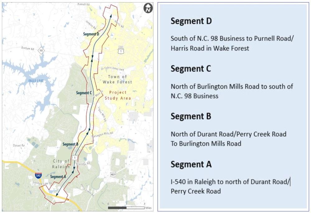
Project U-5307 is divided into four segments for funding and construction purposes. The map and table below provide information on the four segments and their current funding/construction status.
Project Maps from the June 2023 Public Hearing
The table below provides links to the Preferred Alternative/LEDPA (Least Environmentally Damaging, Practicable Alternative) as well as other options previously considered but eliminated. Maps can be viewed or downloaded by clicking on the following links.
U-5307 Preferred Alternative / LEDPA | Other Options Previously Considered | |
|---|---|---|
| I-540 at U.S. 1 | ||
Service Roads included on this map: Jacqueline Lane to Perry Creek Road | A Roundabout Option at Gresham Lake Road and Capital Hills Drive/Overlook Road is being evaluated. The Roundabout Option could be used with the Recommended Alternative (Option 2) or with Option 4. | |
Service Roads included on this map: Capital Hills Drive at Guerbet/Mallinckrodt Wadford Drive Extension to south of the Neuse River | ||
Burlington Mills Road, Option A Service Roads included on this map: Ponderosa Service Road from north of the Neuse River to the Rail Corridor Wadford Drive from north of the Neuse River to Meadstone Way / Burlington Mills Road Pedestrian Bridge over the Neuse River and connecting the Wadford Drive cul-de-sacs also included on this map |
| |
North of Burlington Mills Road to South of Falls of Neuse Road / U.S. 1A (S. Main Street) Service Roads included on this map: Ponderosa Service Road from Rail Corridor to south of Falls of Neuse Road Star Road extension from north of Rail Corridor to south of U.S. 1A (S. Main Street) | ||
Falls of Neuse Road / U.S. 1 A (S. Main Street) Service Roads Included on this map: Ponderosa Service Road south of Wakefield Commons Star Road to U.S. 1A (S. Main Street) | ||
Service Roads included on this map: Future Ligon Mill Road Extension nfrom N.C. 98 Business to Wake Forest Crossing | ||
Service Roads included on this map: Wake Union Church Road from south of Stadium Drive to south of Purnell Road | ||
Purnell Road / Harris Road, Option 2 Service Roads included on this map: Wake Union Church Road south of Purnell Road | ||
Previous Public Meetings
October 2018 - Open House Corridor Public Meeting
November 2021 - Virtual Public Meeting
Responses to questions received at the December 2021 Virtual Public Meeting
June 2023 – Public Hearing
Responses to questions and comments received during the 2023 public comment period
June 21, 2023 Public Hearing Summary
Watch the Recording of the Combined Public Hearing (click here to view a PDF of the Hearing Presentation)
Project Contact Information
Project Contact Information
Sara J. Sherman, PE
Project Manager
NCDOT Project Management Unit
1582 Mail Service Center
Raleigh, NC 27699-1582
Project Contact Information
Charles Cox, PE
Consultant Project Manager
RS&H
6521 Six Forks Road, Suite 400
Raleigh, NC 27615
Title VI Feedback
To ensure we’re hearing from a broad set of voices, would you be willing to share (completely anonymously) some information about yourself?
If so, please click here: https://publicinput.com/NCDOT-Title-VI-Form
RESOURCES FOR PROPERTY OWNERS
Although the N.C. Department of Transportation works to minimize the number of homes and businesses displaced by a road project, it is inevitable, in many cases, that a certain amount of private property is needed. The following information explains right of way acquisition and answers questions about the process.
Right-of-Way Brochure Single Page Layout Folleto del Proceso de Adquisición de Bienes Raíces
Right-of-Way Frequently Asked Questions
Right of way Acquisition Process Videos
Page last updated: April 20 2026