 U-5852: Benjamin Parkway/Bryan Boulevard
U-5852: Benjamin Parkway/Bryan Boulevard
The N.C. Department of Transportation proposes various improvements to Benjamin Parkway/Bryan Boulevard from N. Holden Road to W. Wendover Avenue in Greensboro.
The purpose of the proposed project is to reduce traffic congestion and improve overall traffic flow and carrying capacity within the project limits. By 2040, Benjamin Parkway/Bryan Boulevard is projected to be near or over capacity and improvements are needed to relieve congestion.
Interactive Study Area Map
Project Information
Project Overview Video
The video below provides an overview of the project materials and information shown on this page.
Proposed Design
To avoid, minimize, and balance impacts, two project alternatives have been developed. Both alternatives are the same when comparing vehicular travel lanes and improving intersections.
Both alternatives will:
Add an additional northbound through lane from Green Valley Road to the Holden Road interchange
Add a right turn lane on northbound Benjamin Parkway to Green Valley Road
Add a sidewalk along the northbound side from Pembroke Road to West Cornwallis Drive
Add an additional southbound through lane from Wendover Avenue near Green Valley Road to Benjamin Parkway
Fairway Drive at southbound Benjamin Parkway will operate as a stop-controlled intersection with right-in/right-out only access to Benjamin Parkway
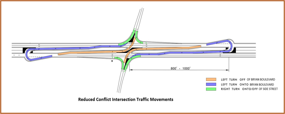
Pembroke Road and Cornwallis Drive intersections will be converted to Reduced Conflict Intersections (RCI). This means that left turns from Pembroke Road and Cornwallis Drive will be prohibited to increase efficiency and safety at the intersections. A U-turn movement would be provided for traffic from Cornwallis Drive in the triangular ramp location near Gracewood Drive.
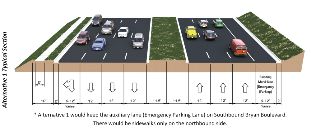
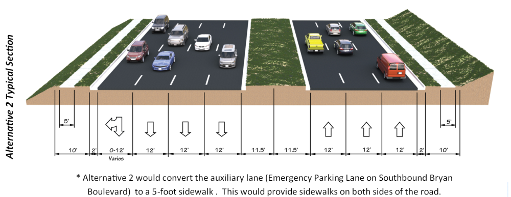
The difference between the two alternatives is how they will treat the existing multi-use lane on Benjamin Parkway southbound between Northhampton Drive and Pembroke Road.
Alternative 1 would preserve the existing multi-use lane
Alternative 2 would convert the existing multi-use lane to a 5-foot sidewalk providing sidewalks on both sides.
Widening of the roadway will occur on the east side to minimize impacts to the historic district and residential properties on the west side of Benjamin Parkway/Bryan Boulevard. Several community features are located along the project corridor including a park (Guilford Hills Park), a historic district (Starmount Mid-Century Historic District), and residential properties. Efforts will be made to avoid/minimize and balance impacts to the extent practicable.
Congestion
The traffic forecast completed in December 2017 shows, the current Average Annual Daily Traffic (AADT) along the corridor ranges from 28,000 to 48,800 vehicles per day (VPD). The traffic volume range is projected to increase to 35,800 to 55,600 VPD by 2040.
A traffic capacity study was to analyze existing and future conditions of the roadway. The level of service (LOS) was measured at each of the intersections. LOS is used to categorize traffic flow based on various performance measures, such as speed, density, and congestion, and is measured using letters A through F with A being the best and F being the worst (see the diagram below). By the year 2040, it is anticipated that all eight signalized intersections within the study area will begin operating at LOS E or F during one of the peak hours. The project is anticipated to improve LOS for seven of the eight signalized intersections to LOS D or better during both of the peak hours. The project is expected to substantially improve overall intersection operation and eliminate/reduce the major bottlenecks.
Safety
To improve safety along the project corridor, Reduced Conflict Intersections (RCI) will be used at the Benjamin Parkway/Bryan Boulevard intersections with Pembroke Road and Cornwallis Drive.
Crash data reports were collected by NCDOT between 2012 and 2017. During the five-year period, there were a total of 224 crashes within the study area with 95 reported as injury crashes and one reported as a fatality. Of the crashes, 59 percent were rear-end crashes, with angle crashes following at 22 percent. The intersection with the highest number of crashes was Benjamin Parkway/Bryan Boulevard at Cornwallis Drive.
The proposed project is part of the Greensboro Urban Area MPO Metropolitan Transportation Plan (2040) and the City of Greensboro Bicycle, Pedestrian, Trails, and Greenways (BiPed) Plan which includes the addition of sidewalk along the project corridor.
Reduced Conflict Intersection
To improve safety and traffic flow along the Benjamin Parkway/Bryan Boulevard project corridor, a partial reduced conflict design is being used. The existing, signalized full movement intersections for Pembroke Road and Cornwallis Drive would be replaced with left-turn movements for north and southbound traffic directed by a raised median island. A U-turn movement would be provided for traffic from Cornwallis Drive at the ramp located near Gracewood Drive. Fairway Drive would be right-in/right-out only. Reduced conflict intersections with traffic signals reduced crashes 15 percent compared to conventional intersections, improve safety for motorists and pedestrians, and can accommodate more traffic without increased delays.
A Reduced Conflict Intersection – sometimes referred to as a superstreet, a synchronized street, or a median U-turn is a general term used to describe several types of designs that can be used to improve safety and traffic flow on a highway by cutting more than half of the potential locations, or conflict points, where drivers and pedestrians can collide.
The most common type of Reduced Conflict Intersection design eliminates left turns from side roads onto busy main roads.
Raised medians direct traffic from the side road into turning right. When there is a safe opening in traffic, drivers enter the flow of traffic on the main route. To go the other direction, or cross the highway, drivers pull into a dedicated lane – typically less than 1,000 feet away – and make a U-turn. There might be a traffic signal at this location.
With a Reduced Conflict Intersection, drivers from the side street only have to be concerned with one direction of traffic on the highway at a time and do not need to wait for a gap in both directions to cross a major road.
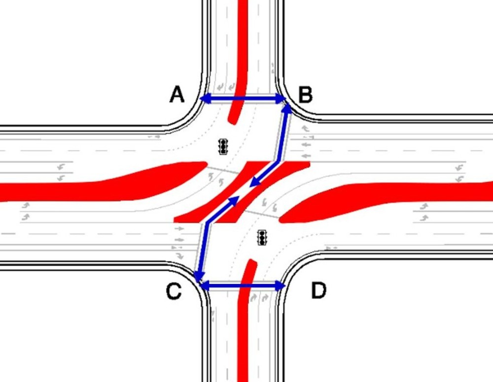
Pedestrian and Bicycle Movements through RCIs
Traffic signals installed at intersections control mainline (Bryan Boulevard/Benjamin Parkway) traffic. Signals will stop north/south bound traffic, allowing U-turns and left turns at the intersection. At this time, bicyclists and pedestrians will follow the path shown in blue below to move across Bryan Boulevard/Benjamin Parkway. This moves the pedestrians crossing Bryan Boulevard/Benjamin Parkway away from moving traffic, providing for safer travel through the intersection.
Project Maps
View/Download PDF of Alternative 1 Map
Typical Section - Alternative 1
View/Download PDF of Alternative 2 Map
Typical Section - Alternative 2
A video explaining how to read a public hearing or meeting map can be viewed below. The video contains information on colors and symbols used.
Historic Properties
NCDOT conducted a preliminary investigation and identified seven resources within the Area of Potential Effects (APE) that warranted additional assessment. The properties consisted of Friendly Shopping Center, Kiser Middle School, Lake Daniel Park, and four post-1945 communities (Garden Homes, Green Valley, Guilford Hills, and Forest Valley). Research revealed that the section of Lake Daniel Park found within the APE was not designated a public park until the 1980s and therefore has been excluded from the evaluation because it is not 50 years of age and does not meet Criterion Exception G.
NCDOT contracted with a firm to evaluate these resources and provide a written report that provided photographs, historic and architectural contexts, evaluation of National Register of Historic Places (NRHP)
eligibility, comparisons to similar types, and delineated boundaries. As a result of this effort Kleinfelder recommends that Kiser Middle School, Garden Homes Historic District, Green Valley Historic District, Guilford Hills Historic District, and Forest Valley Historic District are eligible for listing in the NHRP.
A copy of that report is available by clicking here.
Project Funding
| Estimated Amount* |
|---|---|
Project Development & Design | $ 1 Million |
Right-of-Way/Utilities | $ 1 Million |
Construction | $ 12.5 Million |
Total Costs | $14.5 Million |
* Costs are preliminary subject to change.
Project Schedule
| Date* |
|---|---|
Public Meeting | October 2022 |
Environmental Document | February 2023 |
Right-of-Way Acquisition | 2029 |
Construction | 2031 |
* Future dates are preliminary subject to change.
Public Comment
NCDOT accepts comments throughout all phases of project development.
The public is encouraged to leave comments using the project email or phone number.
Email: benjamin-bryan-improvements@publicinput.com
Phone number: 984-205-6615 enter code 2034
The comment period for the current phase of project development has closed.
Project Contact
NCDOT Project Manager
Colin Mellor
Project Management Unit
1582 Mail Service Center
Raleigh, NC 27699-1582
benjamin-bryan-improvements@publicinput.com
984-205-6615 code 2034
Title VI Feedback
To ensure we’re hearing from a broad set of voices, would you be willing to share (completely anonymously) some information about yourself? If so, please click here (https://publicinput.com/ncdot-title-vi-form)
Resources For Property Owners
Although the N.C. Department of Transportation works to minimize the number of homes and businesses displaced by a road project, it is inevitable, in many cases, that a certain amount of private property is needed. The following information explains right of way acquisition and answers questions about the process.
Right-of-Way Brochure Single Page Layout Folleto del Proceso de Adquisición de Bienes Raíces
Right-of-Way Frequently Asked Questions
Right of way Acquisition Process Videos
Last Updated- February 17 2026