 U-5769: N.C. 16 (Providence Road)
Preliminary Engineering Activities for this project
are underway.
The N.C. Department of Transportation is proposing to make improvements to N.C. 16 (Providence Road South) between Rea Road and Waxhaw Parkway.
Project Vicinity Map
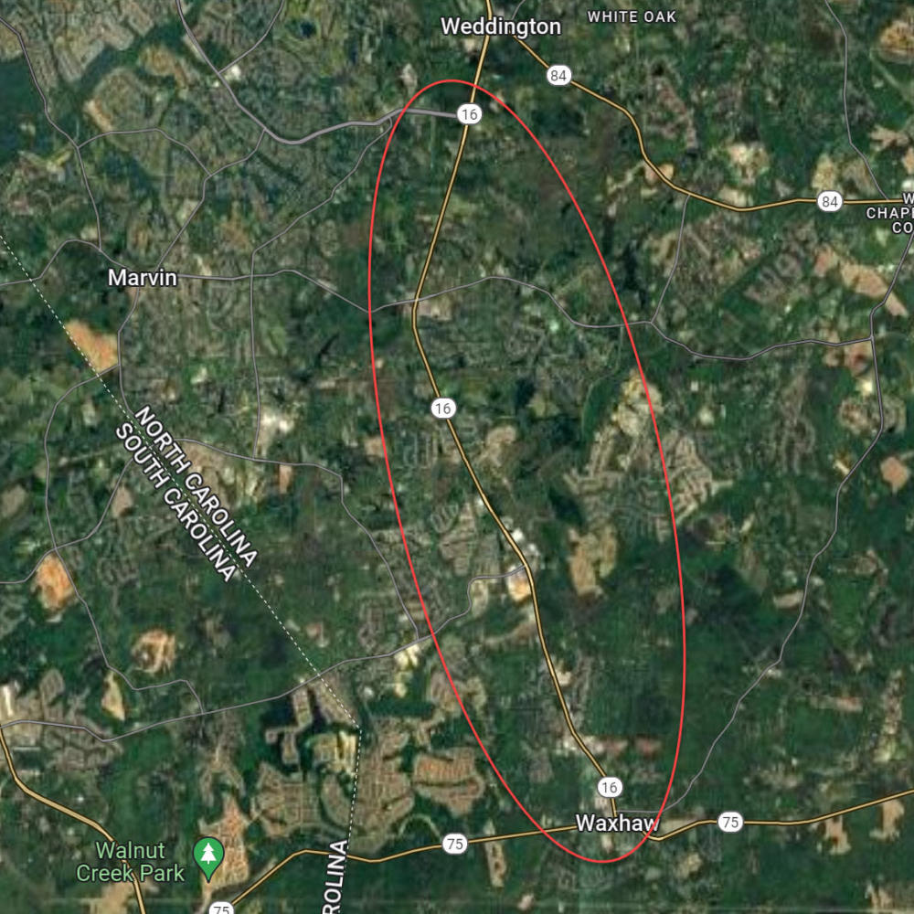
The N.C. Department of Transportation is proposing to make improvements to N.C. 16 (Providence Road South) between Rea Road and Waxhaw Parkway. Improvements proposed include widening N.C. 16 to a four-lane divided facility with a combination of conventional and superstreet typical sections. The purpose of these proposed improvements is to relieve congestion and improve traffic operations; reduce congestion-related crashes; and improve safety as traffic volumes increase.
This project is included in the State Transportation Improvement Program (STIP) as Project Number U-5769 and is the continuation of the four-lane, divided portion of N.C. 16 (Providence Road South) north of Rea Road. Widening of the roadway will promote safety, traffic operations, and relieve current and future congestion.
Public Meetings
A public meeting is scheduled for October 22,2026.
Date
Location
| Thursday - October 22, 2026 Weddington United Methodist Church - Helms Hall 13901 Providence Road Weddington |
Time | 5 p.m. - 7 p.m. |
PROJECT VIDEO
Project Funding
| Estimated Cost* |
Right of Way Acquisition | $ 92.65 million |
Construction | $ 151.90 million |
Total Cost | $ 244.55 million |
* Estimated costs are subject to change. Based oncurrently adopted NCDOT STIP.
Project Timeline
Milestone | Date* |
Right-of-Way Acquisition begins | 2025 |
Construction begins | 2029 |
* Future dates are preliminary and subject to change.
Reduced Conflict Intersections
To learn more about how Reduced Conflict Intersections work please view the video below or visit https://www.ncdot.gov/initiatives-policies/Transportation/safety-mobility/reduced-conflict-intersections/Pages/default.aspx
PROJECT CONTACT INFORMATION
Donald C Griffith
Project Manager
NCDOT Division 10
nc-16-Providence@publicinput.com
984-205-6615 enter code 3254 to leave a message
Documents
- Map 1 Waxhaw Parkway to Kingston Drive.pdf
- Map 2 Ski Trail Lane to Cuthbertson Road.pdf
- Map 3 Sunset Mill Road to Calistoga Lane.pdf
- Map 4 Cutters Spring Drive to Woodmont Drive.pdf
- Map 5 New Town Road to Ennis Road.pdf
- Map 6 Sherringham Way to Old Mill Road.pdf
- Sherringham Way to Old Mill Road.pdf
- U-5769 Presentation to Neighborhoods 12-6-18 in Weddington.pdf
- U-5769 Public Meeting - Boards.pdf
- U-5769-2019-03-14-Meeting - Handout.pdf
- U5769_RDY_PHM 10.8.26_MAP 2_Ski Trail Ln to Cuthberston Rd.pdf
- U5769_RDY_PHM 10.8.26_MAP 3_Sunset Mill Road to Calistoga Lane.pdf
- U5769_RDY_PHM 10.8.26_MAP 4_Cutters Spring Dr. to Woodmont Dr..pdf
- U5769_RDY_PHM 10.8.26_MAP 5_New Town Rd to Ennis Rd.pdf
- U5769_RDY_PHM 10.8.26_MAP 6_Sherringham Way to Old Mill Rd.pdf
- U5769_RDY_PHM 10.8.26_Waxhaw Parkway to Kingston Dr..pdf
Title VI Feedback
To ensure we’re hearing from a broad set of voices, would you be willing to share (completely anonymously) some information about yourself?
If so, please click here: https://publicinput.com/ncdot-title-vi-form
RESOURCES FOR PROPERTY OWNERS
Although the N.C. Department of Transportation works to minimize the number of homes and businesses displaced by a road
project, it is inevitable, in many cases, that a certain amount of private property is needed. The following information explains right
of way acquisition and answers questions about the process.
Right-of-Way Brochure Single Page Layout Folleto del Proceso de Adquisición de Bienes Raíces
Right-of-Way Frequently Asked Questions
Right of Way Acquisition Process Videos
Page Last Updated- October 14 2026
ADA Compliant