 ESVA Waterways
ESVA Waterways
ESVA (Eastern Shore of Virginia) Waterways
Safe and navigable waterways are critical for the economic, cultural, and recreational vitality of the ESVA. In 2016, the Accomack-Northampton Planning District Commission (A-NPDC) partnered with the Eastern Shore of Virginia Regional Navigable Waterways Committee (ESRNWC) and local stakeholders to develop a Regional Dredging Needs Assessment (RDNA). This assessment investigated the existing conditions of 52 channels in the region and identified waterways with restricted navigation which need dredging. The A-NPDC received Virginia Port Authority Waterway Maintenance Funds for dredged material management planning along several of these channels. This project will focus on four waterways: Folly Creek, Nassawadox Creek, Red Bank Creek, and Hungars Creek. This website provides project information, reference material, and the opportunity for the public to provide input on project development.
For the project in Spanish, please click here // Para el proyecto en español, haga clic aquí.
For the project in Haitian Creole, please click here // Pou pwojè a an kreyòl ayisyen, tanpri klike isit la.
Website banner image credits: Flickr (1st), Flickr (2nd), Flickr (3rd), Flickr (4th)
Events
Project Overview
PROJECT UPDATES
Public Meetings
Miss Public Meetings 1, 2 and/or 3?
All meetings are recorded and available for viewing on the "Public Meetings" tab above.
Community Input Survey Results
Please see a summary of the "ESVA Waterways Public Survey Fact Sheet" survey results below, under "Available Presentations, Downloads and News".
Thank you to all who took the time to participate in our Community Input Survey and Interactive Maps!
How to Navigate this Website
This project website is broken down into several tabs, as indicated above. Please make sure to read through "Project Overview" (below) to get a sense of what this project is about. You can also be directed to subpages (below) to learn more about the various waterway channels. "About the A-NPDC" offers information pertaining to the Planning District Commission, along with downloads, resources, and links. "Stay Connected" shows the various ways you can be informed. "The Process" discusses how this project will take place over three (3) stages. "Case Studies" demonstrates examples of the beneficial use of dredged material. And lastly, be sure to check out "FAQs" for any questions related to this project.
Project Overview
The A-NPDC staffs the Eastern Shore Regional Navigable Waterways Committee (ESRNWC), which is charged with advising each County Board with the condition and status of all navigable waterways, prioritizing the Shore’s water navigation needs, and possible solutions to water transport needs. To that end, with support from the Virginia Coastal Zone Management Program, the A-NPDC developed the Regional Dredging Needs Assessment (RDNA), which is to be updated before the end of 2021. This document provides information on existing conditions in focused navigable channels and identifies where navigation has become restricted to the point where dredging is needed.
Geodynamics is completing the channel condition surveys and base mapping and GET Solutions, Inc. is performing the sediment sampling and testing. Moffatt & Nichol is tasked with performing dredge material management planning and community engagement for the four channels. Dredged material management strategies will be developed to improve navigability of waterways and beneficially use dredged material when appropriate. The project aims to improve resiliency, coastal habitat condition, water quality, and/or provide protection for adjacent peoples and infrastructure.
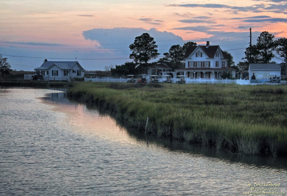
Source: Flickr, M. Druckenbrod, 2020
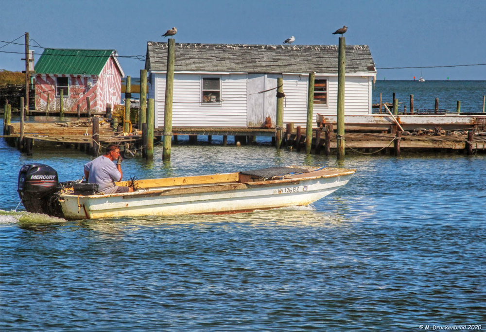
Source: Flickr, M. Druckenbrod, 2020
SUBSCRIBE below! We will share information on the upcoming virtual public meetings, as well as the latest project updates.
Project Background & Details
The Eastern Shore of Virginia is a narrow (approximately 70-mile) coastal peninsula separating the Chesapeake Bay from the Atlantic Ocean with two counties and 19 incorporated towns. The peninsula is buffered from coastal impacts along its Atlantic coast by a barrier island chain and vast tidal marshes. Some areas of its Chesapeake Bay coast are also protected by various islands and tidal marshes. The creeks that shape the Chesapeake Bay coast are generally much larger than those on the ocean or seaside of the peninsula. Historic land-use activities and changes to the dynamic coastal environments have contributed to the sedimentation of many creeks of the Eastern Shore. Furthermore, the region faces unique challenges with regards to coastal flooding, coastal erosion, and inundation from sea-level rise. Potential changes in storm intensity and frequency, and changes in relative sea level, will impact sedimentation patterns that affect the shoaling and navigability of coastal waterways. Additionally, dredging of these areas may provide materials which are suitable for beneficial use to mitigate coastal erosion and flooding and aid in habitat remediation.
Natural processes commonly impact the navigability of the Eastern Shore. This has historically been an issue of concern as access to these waterways is necessary for the economic viability of the coastal peninsula. Inadequate water depths approaching and adjacent to facilities and infrastructure can be disruptive to the economy and residents and tourists can only explore the coastal resources which they can access.
The following are Accomack County and Northampton County projects with project oversight/management being provided by the Accomack-Northampton Planning District Commission (A-NPDC).
Site Context
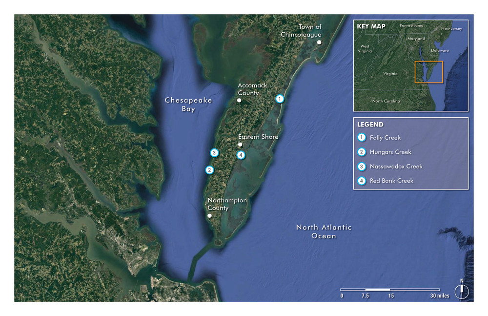
Source: Moffatt & Nichol, 2021
Click the image to show an enlarged version for legibility.
Approximate Locations of the Following Active Project Areas
1. Folly Creek – Eastern Shore of Virginia on the Seaside in Accomack County
2. Hungars Creek – Eastern Shore of Virginia on the Bayside of Northampton County
3. Nassawadox Creek – Eastern Shore of Virginia on the Bayside in Northampton County
4. Red Bank Creek – Eastern Shore of Virginia on the Seaside in Northampton County
Below are links to both active and archived projects. Please navigate each project page to learn more!
Click "Participate" below to learn more about Folly Creek, Hungars Creek, Nassawadox Creek and Red Banks Creek. You will have the opportunity to TAKE OUR SURVEY and PROVIDE COMMENTS on our interactive maps!
Waterway Maintenance Planning for Folly Creek, Hungars Creek, Nassawadox Creek, and Red Banks Creek
Accomack and Northampton Counties were awarded $426,500 from the Virginia Port Authority through the Virginia Waterway Maintenance Fund on July 2, 2020 to complete the Folly Creek, Hungars Creek, Nassawadox...
Other Active Projects 2020: Wachapreague
The following information provides a background overview for Wachapreague, another active channel project in 2020.For the project in Spanish, please click here // Para el proyecto...
Previously Funded Projects 2019: Quinby and Kings Creek
The following information provide a background overview for Quinby and Kings Creek, two previously funded channel projects in 2019.For the project in Spanish, please click here // Para...
Project Schedule and Milestones
The graphic below provides the general timeline of the planning effort for the above four channels.
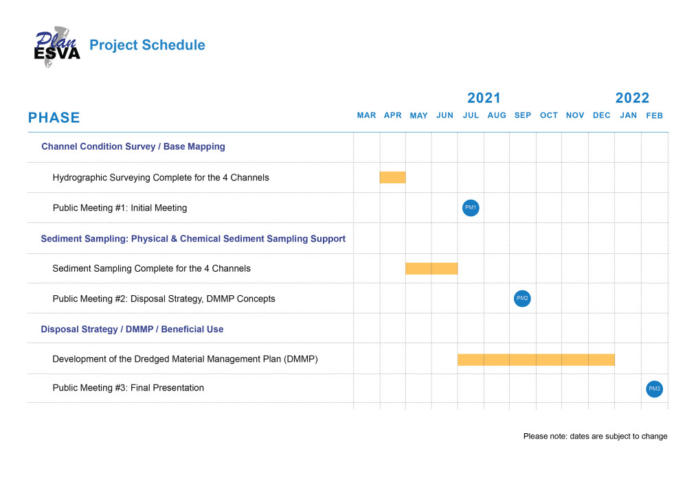
Source: Moffatt & Nichol, 2021
Click the image to show an enlarged version for legibility.
Available Presentations, Downloads and News
The following are various documents available for you to learn more about this important planning effort.