 HB-0040: Wrightsville Beach Bridge Replacements
HB-0040: Wrightsville Beach Bridge Replacements
NCDOT is proposing to replace the bridge on U.S. 76 and the bridges on U.S. 74 in Wrightsville Beach.
Vicinity map and study area:
Vicinity map and study area:
Project Highlights
The N.C. Department of Transportation is proposing to replace the bridge on U.S. 76 (Causeway Drive) and the two bridges and on U.S. 74 (West Salisbury Street) in Wrightsville Beach.
The project will remove the existing bridges and replace each with a new bridge adjacent to the existing. The proposed bridges will include the following design elements:
U.S. 76 (Causeway Drive) crossing Banks Channel
- 4-lane bridge
- two (2) eastbound lanes traveling to the island (11-ft lanes)
- two (2) westbound lanes leaving the island (11-ft lanes)
- 12-ft multi-use path on the north side of the bridge
- one (1) 6-ft bike lane eastbound onto the island
- one (1) 6-foot bike lane westbound leaving the island
Bridges along U.S. 74 (W. Salisbury Street) crossing Lees Cut and Banks Channel
- two (2) 12-ft lanes (one lane in each direction)
- 12-ft multi-use path on the south side of the bridge
- two (2) 6-ft bike lanes.
Construction of Lee’s Cut bridge (#22) on U.S. 74 (W. Salisbury Street) will be completed first while U.S. 76 (Causeway Drive) and bridge #24 over Banks Channel will remain open on U.S. 74. The road at the location of Lee’s Cut will be closed during the duration of the bridge construction. Upon completion of Lee’s Cut bridge, bridge #24 will begin construction. The roadway at bridge #24 over Banks Channel will be closed and vehicles will be detoured to Causeway Drive.
The construction of the northern half of bridge #21 (Causeway Drive) can occur concurrently with the construction of bridge #24. Constructing the northern half of bridge #21 will allow traffic to remain on the existing Causeway Drive bridge and prevent detouring traffic from this area. Once the construction for the northern half of bridge #21 (Causeway Drive) is completed, traffic will be shifted to the newly constructed bridge on Causeway Drive and construction of the southern half of bridge #21 will begin. The construction of bridges #24 and #21 will be done using top-down construction to minimize impacts to utilities and parcels in the surrounding area of the bridges.
The purpose of the project is to replace the aging structures thereby improving connectivity and providing a long term, safe and efficient multi modal crossing of Lee’s Cut and Banks Channel.
- Contract crews for the N.C. Department of Transportation will begin utility relocation this summer (2026).
- Utility relocation will begin this summer around the smaller bridge on West Salisbury Street (U.S. 74) over Lees Cut and will involve intermittent lane closures. This work is critical to prepare the area for the replacement of the bridge.
- Construction of the smaller bridge on West Salisbury Street over Lees Cut is expected to begin by the end of 2026. The smaller bridge will not close to traffic for replacement until after Labor Day.
_____________________________________________
A summary document containing responses to comments and questions submitted can be viewed here.
Project Map
U.S. 76 (Causeway Drive) Bridge
Click on the link or the thumbnail below to view or download the maps

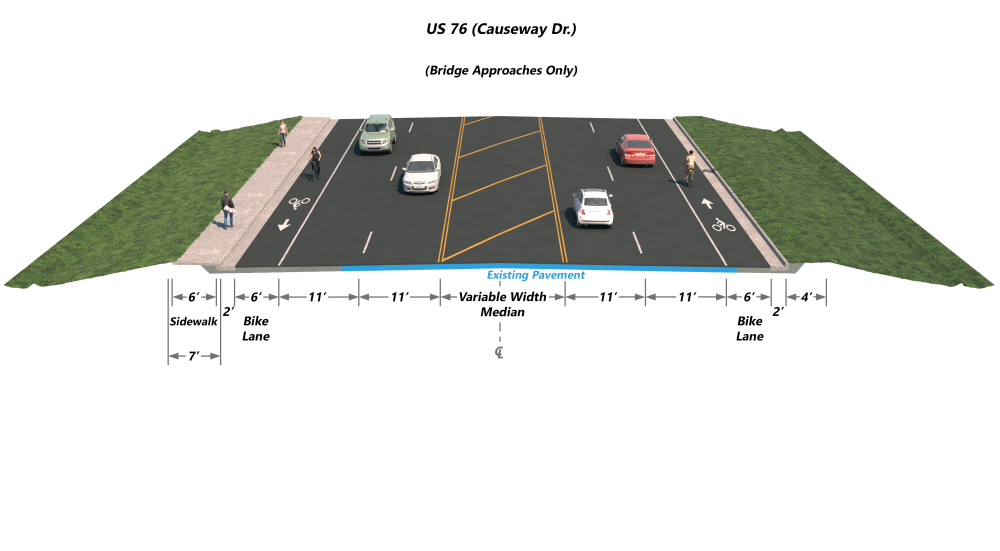
Typical Section
Bridge approaches along U.S. 76 (Causeway Drive)
_____________________________________________
Project Map
U.S. 74 (W. Salisbury Street) Bridges
Click on the link or the thumbnail below to view or download the maps

Typical Section
Bridges along U.S. 74 (W. Salisbury Street) crossing Lees Cut and Banks Channel

Bridge Approaches U.S. 74 (W. Salisbury Street)

_____________________________________________
Project Costs
Activity | Cost* |
Right of Way Acquisition | $ 32.2 million |
Utility Relocation | $ 2.0 million |
Construction Cost | $ 70.8 million |
Total Cost | $ 105 million |
*Estimated costs are subject to change. Based on currently adopted NCDOT State Transportation Improvement Program.
Project Timeline
Milestone | Date* |
Public Meeting | Sept. 2023 |
| Environmental Document Complete | Sept. 2024 |
Right of Way Acquisition Began | July 2025 |
| Utility Relocation Begins | Summer 2026 |
Construction Begins | June 2026 |
* Schedule is preliminary and subject to change
Project Comments
NCDOT accepts comments throughout all phases of project development.
All comments will be taken into consideration, and carry equal weight, regardless of submittal method.
The public is encouraged to leave comments using this webpage, email, or phone number:
Email: wrightsvillebeach-bridges@PublicInput.com
Phone Number: 984-205-6615 enter project code 4055 to leave a message
Project Contact
Derek Pielech, PE
NCDOT Division Highway 3
Project Manager
5501 Barbados Boulevard
Castle Hayne, NC 28429
Project Contact
Todd D. Lapham
NCDOT Alternative Delivery Unit
Project Engineer
1020 Birch Ridge Drive
Raleigh, NC 27610
Title VI Feedback
To ensure we’re hearing from a broad set of voices, would you be willing to share (completely anonymously) some information about yourself?
If so, please click here: https://publicinput.com/NCDOT-Title-VI-Form
RESOURCES FOR PROPERTY OWNERS
Although the N.C. Department of Transportation works to minimize the number of homes and businesses displaced by a road project, it is inevitable, in many cases, that a certain amount of private property is needed. The following information explains right of way acquisition and answers questions about the process.
Right-of-Way Brochure Single Page Layout Folleto del Proceso de Adquisición de Bienes Raíces
Right-of-Way Frequently Asked Questions
Right of way Acquisition Process Videos
Last Updated: June 16, 2026
ADA Compliant