Last October, the owners of Major League Soccer’s Columbus Crew announced that they were contemplating relocation. Austin was at the top of their list. But could the city handle the responsibilities that would come with it? Would residents support building the stadium on city-owned land?
While informal community surveys had been conducted, city leaders wanted to solicit public comments with a more formal community engagement survey to see if its citizens were on board.
The biggest question was the location of a new stadium. The team owners wanted to partner with Austin to find a city-owned site. After an exhaustive analysis – with several sites being removed after public opposition – both parties identified a potential location. Elected officials asked staff to figure out how to do a community assessment and conduct a community opinion survey.
The staff recognized that in-person meetings would only go so far. Professional sports is an issue of citywide interest, as is the disposition of taxpayer-owned land. Digital tools like a community polling app or online town hall would enable officials to broaden the conversation across the region.
But there was a problem.
As the #MLStoATX movement was growing in Austin, Columbus fans were leading an equally enthusiastic uprising to #SaveTheCrew. Local leaders wanted to ensure that their community engagement survey wouldn’t be disrupted by out-of-state Columbus fans who would invalidate the results. How could they ensure that the public comment survey was only taking Austinites into account?
The city’s community engagement team and its technology vendor, PublicInput.com, had an answer.
PublicInput.com suggested that Austin integrate geoIP data to infer the locations of online town hall participants. If a location wasn’t provided, a rough estimate could be inferred.
If a Columbus resident typed an Austin address as his or her location, the IP-inferred location would catch the discrepancy and invalidate the results.
With this system in place, organization leaders accepted the approach and the community engagement team moved forward.
Putting GeoData to the test
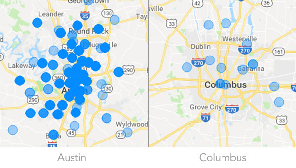
The real test came when a Columbus sports reporter tweeted a link to the community assessment survey. There was nothing to prevent #SaveTheCrew fans from taking the survey. Could this be the moment officials had feared?
The short answer was no.
By segmenting the results by geoIP, the community engagement team was able to provide decision makers with results by county and council district. In the end, PublicInput.com’s system showed that out of 1,024 participants, fewer than 20 were from the Columbus area.
Austin’s community engagement team was able to reassure elected officials and build support for online public engagement as a valuable piece of their engagement “toolbox” for future projects.
In this case, the data confirmed strong resident support for moving forward with the stadium project. Among Austin residents, 80% reported feeling “very positive” about the project. Just 6% of Columbus residents felt that way.
The geodata provided additional information as well. While all Council districts agreed that transportation infrastructure was the top priority, they differed as to whether affordable housing or a new recreation space was the next most important. The segmented location information provided elected officials with a better sense of the priorities of their own constituents.
A milestone in digital public engagement
The project represented a key milestone in the partnership between Austin and PublicInput.com, and a new frontier for the role of data in public engagement. “Austin has always pushed us to integrate more of the online and offline aspects of public engagement,” offered CEO Jay Dawkins. “The MLS project showed how that approach can ultimately build trust with stakeholders and residents alike.”
Today the project is moving forward with council approval, and team owners have cited the key factor being broad support from Austinites “across all districts and backgrounds”.
View the full case study on this community engagement project in Austin.
Learn more about Geodata and GeoIP:
Sign up here to receive info on how to leverage geodata for your process, and get a glimpse of up and coming functionality:
[gravityform id=”3″ title=”true” description=”true”]